- Augustine Volcano
-
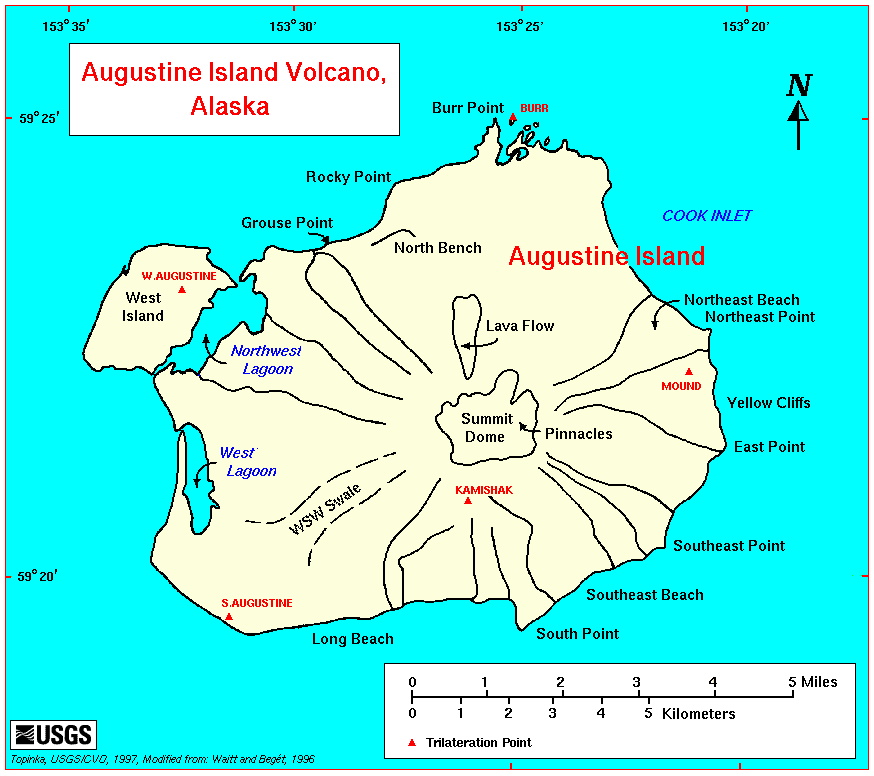
Augustine Volcano 
Augustine Volcano, 1976Elevation 4,134 ft (1,260 m) [1] Listing List of volcanoes in the United States Location Location Cook Inlet, Alaska, USA Coordinates 59°21′48″N 153°26′00″W / 59.36333°N 153.4333333°WCoordinates: 59°21′48″N 153°26′00″W / 59.36333°N 153.4333333°W[2] Topo map USGS Iliamna B-2 Geology Type Lava domes[2] Age of rock more than 40,000 years[2] Volcanic arc/belt Aleutian Arc Last eruption 2006[2] Augustine Volcano is a Lava Dome Complex on Augustine Island in southwestern Cook Inlet in the Kenai Peninsula Borough of southcentral coastal Alaska, 280 kilometers (174 mi) southwest of Anchorage. The Alaska Volcano Observatory currently rates Mount Augustine as Level of Concern Color Code Green for aviation and the Volcano Alert Level is at Normal. Augustine Island has a land area of 83.872 square kilometers (32.4 sq mi), while West Island, just off Augustine's western shores, has 5.142 km2 (2.0 sq mi).
The island is made up mainly of past eruption deposits. Scientists have been able to discern that past dome collapse has resulted in large avalanches.
Contents
Description and geologic history
The nearly circular uninhabited island formed by Augustine Volcano is 12 km (7.5 mi) wide east-west, 10 km (6 mi) north-south; a nearly symmetrical central summit peaks at altitude 4,134 feet (1,260 m).

Augustine's summit consists of several overlapping lava dome complexes placed during many historic and prehistoric eruptions. Most of the fragmental debris exposed along its slopes comprises angular blocks of dome-rock andesite, typically of cobble to boulder size but carrying clasts as large as 4 to 8 meters (10 to 25 feet), rarely as large as 30 meters (100 ft). The surface of such deposits is skeet, a field of steep conical mounds and intervening depressions with many meters of local relief. En route to Katmai in 1913, Robert F. Griggs had briefly inferred landslide (debris avalanche) as the origin of Augustine's hummocky coastal topography about Burr Point, by geomorphic analogy with the hummocky and blocky deposit of a 1912 landslide near Katmai.
The hummocky deposits on Augustine's lower flanks resemble both topographically and lithologically those of the great landslide or debris avalanche that initiated the spectacular May 18, 1980 eruption of Mount St. Helens. The deposit of that landslide revealed the origin of coarse diamicts with hummocky topography at other strato volcanic cones. Since 1980 many hummocky coarsely fragmental deposits on Augustine's lower flanks have come to be interpreted as deposits of numerous great landslides and debris avalanches.
Eruptive activity
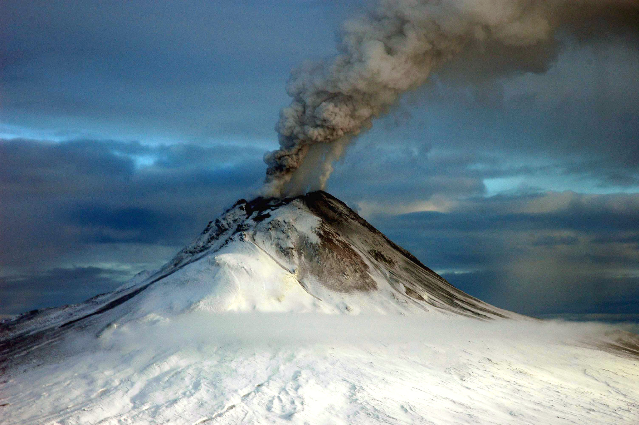
 Thermal image after the January 2006 eruptions. White parts of the image are warmer than dark areas.
A March 27, 1986 eruption deposited ash over Anchorage and disrupted air traffic in southcentral Alaska.
On January 11, 1994, Augustine erupted at 13:44 and 14:13 UTC.
2006
In mid-December 2005 a sulfur dioxide-laden plume of steam, hundreds of miniature earthquakes and a new coating of ash over its currently snow-clad peak, taken together, suggested that Augustine was building to a new eruption, likely in 2006.[3] The eruption consisted of four "phases", continuing from December to March 2006.
The initial stage of the eruption began when microearthquake activity increased steadily from May to December 2005. At first, they started out at around 2 each day to around 15 each day. Microearthquakes are tiny earthquake that suggest a volcanic eruption could possibly occur.[4]
The volcano erupted on January 11, entering a second "stage", which would continue until January 28. Tectonic earthquakes began early on January, resulting in an explosive Volcanic Explosivity Index 3 eruption later in the day. Several ash columns were generated, each 9 km (6 mi) above sea level; these plumes were steadily influenced to the north and northeast of the volcano. Samples of the tephra were dense, insinuating that the lava released was mature.[4]
Six explosions were recorded by seismic instruments between January 13, the first of these consuming a seismograph and a CPGS located on the northwestern flank. Ash columns now reached 14 km (9 mi) and Kenai Peninsula residents reported ash deposits. On January 16, a new lava dome was observed on the summit; and the next day another explosive eruption sent ash 13 km (8 mi) into the atmosphere. This explosion created a 20-30 meter wide crater in the new lava dome.[4]
 2006 eruption
On September 22, 2007, the Alaska Volcano Observatory reported that shallow earthquake activity had increased over the week of September 22. However, the activity was less than its level during the months leading up to the 2005-2006 eruption.
Sensor Networks
The Plate Boundary Observatory, operated by UNAVCO has a network of 10 high-precision GPS instruments on the flanks of Augustine. Activity two years ago claimed two of these sites. The Alaska Volcano Observatory also operates a number of seismometers and tiltmeters all around the volcano, including four webcams.
See also
- List of volcanoes in the United States
References
- ^ "Augustine Description and Statistics". Alaska Volcano Observatory. United States Geological Survey. http://www.avo.alaska.edu/volcanoes/volcinfo.php?volcname=Augustine. Retrieved 2009-01-19.
- ^ a b c d "Augustine". Global Volcanism Program, Smithsonian Institution. http://www.volcano.si.edu/world/volcano.cfm?vnum=1103-01-. Retrieved 2009-01-19.
- ^ [1][dead link]
- ^ a b c "Event Specific Information: Augustine - 2005". Alaska Volcano Observatory. United States Geological Survey. http://www.avo.alaska.edu/volcanoes/volcact.php?volcname=Augustine&eruptionid=547&page=basics. Retrieved February 3, 2008.
- Augustine Island and West Island: Blocks 1070 thru 1073, Census Tract 1, Kenai Peninsula Borough, Alaska United States Census Bureau
External links
Categories:- Active volcanoes
- Stratovolcanoes
- Mountains of Alaska
- Volcanoes of Alaska
- Lava domes
- Complex volcanoes
- Landforms of Kenai Peninsula Borough, Alaska


Wikimedia Foundation. 2010.