- Miran (China)
-
Miran is an ancient oasis town located on the southern rim of the Taklamakan Desert in China, along the famous trade route known as the Silk Road where the Lop Nur desert meets the Altun Shan mountains. Two thousand years ago a river flowed down from the mountain and Miran had a sophisticated irrigation system. Now the ruined city is a sparsely inhabited dusty spot with poor roads and minimal transportation in the Xinjiang Autonomous Region of the People's Republic of China.[1]
Contents
Names
Lionel Giles has recorded the following names for Miran (with his Wade-Giles forms of the Chinese names converted to pinyin):
- "Yuni, old capital of Loulan [Former Han]
- "Old Eastern Town" ; "Little Shanshan" [Later Han]
- Qitun Cheng ; Tun Cheng [Tang]
- Mirān [modern name].[2]
History
In ancient times Miran was a busy trading center on the southern part of the Silk Road, after the route split into two (the northern route and the southern route), as caravans of merchants sought to escape travel across the harsh wasteland of the desert (called by the Chinese "The Sea of Death") and the Tarim Basin. They went by going around its north or south rim. It was also a thriving center of Buddhism with many monasteries and stupas.[1][3][4]
After the fourth century the trading center declined. In the mid eighth century, Miran became a fort town because of its location at the mouth of a pass. This is where the Tibetan forces crossed when the Chinese army withdrew to deal with rebels in central China. The Tibetans remained there, using the old irrigation system, until the last Yarlung culture king was assassinated with no designated successor in the mid-ninth century and the Tibetan Empire fell.[1]
Archaeology
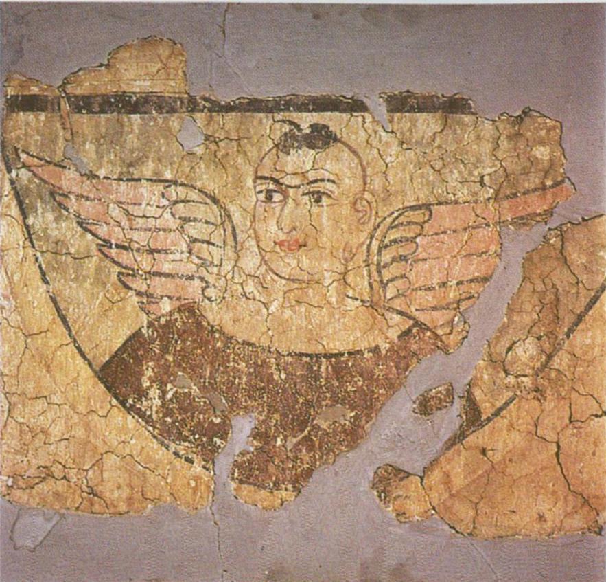
Marc Aurel Stein was the first archaeologist to systematically study the ruins at Miran in 1907. The many artifacts found in Miran demonstrate the extensive and sophisticated trade connections these ancient towns had with places as far away as the Mediterranean Sea. Archaeological evidence from Miran shows the influence of Buddhism on artistic work as early as the first century BC.[5] Early Buddhist sculptures and murals excavated from the site show stylistic similarities to the traditions of Central Asia and North India[6] and other artistic aspects of the paintings found there suggest that Miran had a direct connection with Rome and its provinces.[7]
A wealth of manuscripts have been found, mostly official Tibetan documents and military information from the fort, written in early Tibetan script on wood or paper, dating the eighth and ninth century. Since the Tibetan script was invented a century before, these are some of the earliest examples of the script.[1] Coordinates: 39°15′N 88°49′E / 39.25°N 88.817°E
Footnotes
- ^ a b c d The Silk Road: Trade, Travel, War and Faith. http://books.google.com/books?id=ArWLD4Qop38C&pg=PA189&lpg=PA189&dq=miran+china&source=web&ots=egCocMOmcJ&sig=EOvmfCuso4710WGlfZLDhwRZSvA. Retrieved 2007-08-25.
- ^ Giles (1930-1932), p. 845.
- ^ "Southern Silk Road". http://dg.chinastage.com/index.jsp?cid=79801&action=viewLocation&locationId=23457. Retrieved 2007-08-25.
- ^ Hill (2009), pp. 89-90, 93, 98, 137, 269.
- ^ The Iconography of Chinese Buddhism in Traditional China. 1986. http://books.google.com/books?id=9XolVmmontwC&pg=PA1&lpg=PA1&dq=miran+china&source=web&ots=fB-49zZpA6&sig=kip-nRkr1rT718wunGUoE-5B8Lg#PPP1,M1. Retrieved 2007-08-25.
- ^ "Silk Road Trade Routes". University of Washington. http://depts.washington.edu/silkroad/exhibit/trade/trade.html. Retrieved 2007-08-25.
- ^ "Ten Centuries of Art on the Silk Road". http://www.asianart.com/forum/serindia.html. Retrieved 2007-08-25.
References
- Giles, Lionel (1930-1932). "A Chinese Geographical Text of the Ninth Century." BSOS VI, pp. 825-846.
- Hill, John E. (2009) Through the Jade Gate to Rome: A Study of the Silk Routes during the Later Han Dynasty, 1st to 2nd Centuries CE. BookSurge, Charleston, South Carolina. ISBN 978-1-4392-2134-1.
External links
Categories:- Former populated places in Xinjiang
- Archaeological sites in China
- Populated places along the Silk Road
- Sites along the Silk Road
- Oases of China
Wikimedia Foundation. 2010.