- Schofield Barracks, Hawai'i
Infobox Military Structure
name=Schofield Barracks
location=Oahu, Hawaii
caption=A U.S. Army soldier practices with a M16A2 at Schofield Barracks
type=Army post
built=1908
materials=
used=1909–Present
controlledby=U.S. Army
garrison=25th Infantry Division
commanders=
battles=Infobox Settlement
official_name = Schofield Barracks, Hawaii
other_name =
native_name =
nickname =
settlement_type = CDP
motto =
imagesize =
image_caption =
flag_size =
image_
seal_size =
image_shield =
shield_size =
image_blank_emblem =
blank_emblem_type =
blank_emblem_size =
imagesize =
image_caption =
flag_size =
image_
seal_size =
image_shield =
shield_size =
image_blank_emblem =
blank_emblem_type =
blank_emblem_size =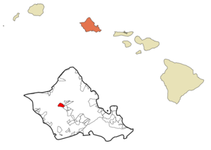
mapsize =
map_caption = Location in Honolulu County and the state ofHawaii
mapsize1 =
map_caption1 =
image_dot_
dot_mapsize =
dot_map_caption =
dot_x =
dot_y =
pushpin_
pushpin_label_position =
pushpin_map_caption =
pushpin_mapsize =
subdivision_type = Country
subdivision_name =United States
subdivision_type1 = State
subdivision_name1 =Hawaii
subdivision_type2 =
subdivision_name2 =
subdivision_type3 =
subdivision_name3 =
subdivision_type4 =
subdivision_name4 =
government_footnotes =
government_type =
leader_title =
leader_name =
leader_title1 =
leader_name1 =
leader_title2 =
leader_name2 =
leader_title3 =
leader_name3 =
leader_title4 =
leader_name4 =
established_title =
established_date =
established_title2 =
established_date2 =
established_title3 =
established_date3 =
area_magnitude =
unit_pref = Imperial
area_footnotes =
area_total_km2 = 7.1
area_land_km2 = 7.1
area_water_km2 = 0.0
area_total_sq_mi = 2.7
area_land_sq_mi = 2.7
area_water_sq_mi = 0.0
area_water_percent =
area_urban_km2 =
area_urban_sq_mi =
area_metro_km2 =
area_metro_sq_mi =
area_blank1_title =
area_blank1_km2 =
area_blank1_sq_mi =
population_as_of = 2000
population_footnotes =
population_note =
population_total = 14428
population_density_km2 = 2027.6
population_density_sq_mi = 5251.5
population_metro =
population_density_metro_km2 =
population_density_metro_sq_mi =
population_urban =
population_density_urban_km2 =
population_density_urban_sq_mi =
population_blank1_title =
population_blank1 =
population_density_blank1_km2 =
population_density_blank1_sq_mi =
timezone = Hawaii-Aleutian
utc_offset = -10
timezone_DST =
utc_offset_DST =
latd = 21
latm = 29
lats = 52
latNS = N
longd = 158
longm = 3
longs = 48
longEW = W
elevation_footnotes =
elevation_m =
elevation_ft =
postal_code_type =ZIP code
postal_code = 96786
area_code = 808
blank_name = FIPS code
blank_info = 15-69050
blank1_name =
blank1_info =
website =
footnotes =Schofield Barracks is a
United States Army installation andcensus-designated place (CDP) located in theCity and County of Honolulu and in the Wahiawa District of the island of Ookinaahu, Hawaiokinai,United States . Schofield Barracks lies adjacent to the town of Wahiawā, separated from most of it byLake Wilson (also known as Wahiawā Reservoir). Schofield Barracks is named after Lieutenant GeneralJohn McAllister Schofield . He was sent to Hawaiokinai in 1872 as Secretary of War forPresident of the United States Andrew Johnson and recommended the establishment of a naval base atPearl Harbor .Schofield Barracks occupies some convert|17725|acre|km2|0 on Central Ookinaahu. The base was established in 1908 to provide mobile defense of Pearl Harbor and the entire island. It has been the home of the 25th Infantry Division, known as the Tropic Lightning Division, since 1941. The population was 14,428 at the 2000 census.
Geography
Schofield Barracks is located at coor dms|21|29|52|N|158|3|48|W|city (21.497650, -158.063248)GR|1. The Main Gate used to be off Wilikina Drive; However, now only the Foote and Lyman gates located along Kunia Road are used for controlled access. Proceeding north on Wilikina Road (State Rte. 99) leads to intersections with Kaukonahua Road (State Rte. 801) to Wailua and Kamehameha Highway (State Rte. 99) to Haleokinaiwa. East on Wilikina leads to
Interstate H-2 and Kamehameha Highway (State Rte.s 80 and 99) to Wahiawā and Mililani Town. Proceeding south on Kunia Road (State Route 750) past Schofield leads to the Kunia Gate on Wheeler,Kunia , and eventually Waipahu.According to the
United States Census Bureau , the base has a total area of 2.8square mile s (7.1km² ), all of it land.Demographics
As of the
census GR|2 of 2000, there were 14,428 people, 2,965 households, and 2,902 families residing in the CDP. Thepopulation density was 5,251.5 people per square mile (2,025.7/km²). There were 3,733 housing units at an average density of 1,358.7/sq mi (524.1/km²). The racial makeup of the CDP was 56.40% White, 21.86% African American, 1.10% Native American, 3.87% Asian, 1.65% Pacific Islander, 8.64% from other races, and 6.49% from two or more races. Hispanic or Latino of any race were 16.20% of the population. Due to the transient nature of American military installation, Schofield Barracks demographics is quite unlike that of Hawaii in general - it has the highest percentage of blacks and Hispanics, and one of the lowest percentages of either Asians or Pacific Islanders, of any CDP in the state.There were 2,965 households out of which 78.0% had children under the age of 18 living with them, 91.5% were married couples living together, 4.8% had a female householder with no husband present, and 2.1% were non-families. 2.0% of all households were made up of individuals and none had someone living alone who was 65 years of age or older. The average household size was 3.55 and the average family size was 3.58.
In the CDP the population was spread out with 32.1% under the age of 18, 29.8% from 18 to 24, 36.6% from 25 to 44, 1.4% from 45 to 64, and 0.1% who were 65 years of age or older. The median age was 22 years. For every 100 females there were 152.3 males. For every 100 females age 18 and over, there were 183.6 males.
The median income for a household in the CDP was $33,788, and the median income for a family was $32,970. Males had a median income of $21,112 versus $18,737 for females. The
per capita income for the CDP was $12,316. About 6.7% of families and 7.2% of the population were below thepoverty line , including 8.5% of those under age 18 and none of those age 65 or over.References
External links
*" [http://www.army.mil/cmh-pg/matrix/25ID/25id-matrix.htm Tropic Lightning] " 25th Infantry Division
*" [http://www.25idl.army.mil/ 25th ID(L) Homepage] "
Wikimedia Foundation. 2010.