- McRae, Georgia
-
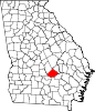
McRae, Georgia — City — Location in Telfair County and the state of Georgia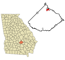
Coordinates: 32°3′52″N 82°53′54″W / 32.06444°N 82.89833°WCoordinates: 32°3′52″N 82°53′54″W / 32.06444°N 82.89833°W Country United States State Georgia County Telfair Area – Total 3.4 sq mi (8.8 km2) – Land 3.4 sq mi (8.7 km2) – Water 0 sq mi (0.1 km2) Elevation 246 ft (75 m) Population (2000) – Total 2,682 – Density 788.8/sq mi (304.8/km2) Time zone Eastern (EST) (UTC-5) – Summer (DST) EDT (UTC-4) ZIP code 31055 Area code(s) 229 FIPS code 13-49084[1] GNIS feature ID 0317973[2] McRae is a town in Telfair County, Georgia, United States. Based on the 2000 census, the town has a total population of 2,682. Between 1990 and 2000, the town experienced a population decrease of 10.8%, compared to the state growth during this period of 26.4%. The town is the county seat of Telfair County[3]. McRae was incorporated March 3, 1874 and was named for a pioneering Scottish family.
Located in downtown McRae is Liberty Square, home of a Statue of Liberty replica that is one-twelfth the original's actual size. There is also a copy of the Liberty Bell and a marble memorial to Telfair County residents who died in service.
On the outskirts of McRae is the Talmadge Home. This historic site was the home of two former Georgia Governors, Eugene Talmadge and Herman Eugene Talmadge. McRae was also the birthplace of Marion B. Folsom (1893–1976), a longtime executive of the Eastman Kodak Company who served as Secretary of Health, Education and Welfare during the administration of President Eisenhower.
Contents
Education
Telfair County School District
The Telfair County School District holds grades pre-school to grade twelve, that consists of one elementary school, a middle school, and a high school.[4] The district has 112 full-time teachers and over 1,648 students.[5]
- Telfair County Elementary School
- Telfair County Middle School
- Telfair County High School
Geography
McRae is located at 32°3′52″N 82°53′54″W / 32.06444°N 82.89833°W (32.064508, -82.898251)[6].
According to the United States Census Bureau, the city has a total area of 3.4 square miles (8.8 km2), of which, 3.4 square miles (8.8 km2) of it is land and 0.04 square miles (0.10 km2) of it (0.59%) is water.
Demographics
As of the census[1] of 2000, there were 2,682 people, 1,057 households, and 714 families residing in the city. The population density was 796.7 people per square mile (307.3/km²). There were 1,310 housing units at an average density of 389.1 per square mile (150.1/km²). The racial makeup of the city was 55.48% White, 42.69% African American, 0.30% Asian, 1.12% from other races, and 0.41% from two or more races. Hispanic or Latino of any race were 1.57% of the population.
There were 1,057 households out of which 30.7% had children under the age of 18 living with them, 43.1% were married couples living together, 19.7% had a female householder with no husband present, and 32.4% were non-families. 30.3% of all households were made up of individuals and 15.9% had someone living alone who was 65 years of age or older. The average household size was 2.40 and the average family size was 2.94.
In the city the population was spread out with 24.0% under the age of 18, 8.2% from 18 to 24, 24.9% from 25 to 44, 22.1% from 45 to 64, and 20.9% who were 65 years of age or older. The median age was 40 years. For every 100 females there were 81.3 males. For every 100 females age 18 and over, there were 75.0 males.
The median income for a household in the city was $27,236, and the median income for a family was $37,250. Males had a median income of $29,055 versus $20,321 for females. The per capita income for the city was $15,911. About 16.4% of families and 19.3% of the population were below the poverty line, including 23.4% of those under age 18 and 25.2% of those age 65 or over.
References
- ^ a b "American FactFinder". United States Census Bureau. http://factfinder.census.gov. Retrieved 2008-01-31.
- ^ "US Board on Geographic Names". United States Geological Survey. 2007-10-25. http://geonames.usgs.gov. Retrieved 2008-01-31.
- ^ "Find a County". National Association of Counties. http://www.naco.org/Counties/Pages/FindACounty.aspx. Retrieved 2011-06-07.
- ^ Georgia Board of Education, Retrieved June 27, 2010.
- ^ School Stats, Retrieved June 27, 2010.
- ^ "US Gazetteer files: 2010, 2000, and 1990". United States Census Bureau. 2011-02-12. http://www.census.gov/geo/www/gazetteer/gazette.html. Retrieved 2011-04-23.
External links
Municipalities and communities of Telfair County, Georgia Cities Helena‡ | Lumber City | McRae | Milan‡ | Scotland‡
Town Footnotes ‡This populated place also has portions in an adjacent county or counties
Categories:- Cities in Georgia (U.S. state)
- Populated places in Telfair County, Georgia
- County seats in Georgia (U.S. state)


Wikimedia Foundation. 2010.