- Culloden, Georgia
-
Culloden, Georgia — City — Location in Monroe County and the state of Georgia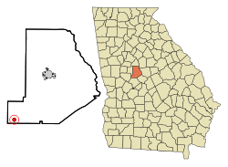
Coordinates: 32°51′47″N 84°5′37″W / 32.86306°N 84.09361°WCoordinates: 32°51′47″N 84°5′37″W / 32.86306°N 84.09361°W Country United States State Georgia County Monroe Area – Total 0.8 sq mi (2 km2) – Land 0.8 sq mi (2 km2) – Water 0 sq mi (0 km2) Elevation 725 ft (221 m) Population (2000) – Total 223 – Density 278.8/sq mi (111.5/km2) Time zone Eastern (EST) (UTC-5) – Summer (DST) EDT (UTC-4) ZIP code 31016 Area code(s) 478 FIPS code 13-20848[1] GNIS feature ID 0355402[2] Culloden is a city in Monroe County, Georgia, United States. The population was 223 at the 2000 census. It is part of the Macon Metropolitan Statistical Area.
Geography
Culloden is located at 32°51′47″N 84°5′37″W / 32.86306°N 84.09361°W (32.863155, -84.093621)[3].
According to the United States Census Bureau, the city has a total area of 0.8 square miles (2.1 km2), of which, 0.8 square miles (2.1 km2) of it is land and 1.27% is water.
Demographics
As of the census[1] of 2000, there were 223 people, 86 households, and 60 families residing in the city. The population density was 288.2 people per square mile (111.8/km²). There were 95 housing units at an average density of 122.8 per square mile (47.6/km²). The racial makeup of the city was 29.15% White and 70.85% African American. Hispanic or Latino of any race were 0.45% of the population.
There were 86 households out of which 22.1% had children under the age of 18 living with them, 44.2% were married couples living together, 18.6% had a female householder with no husband present, and 30.2% were non-families. 27.9% of all households were made up of individuals and 8.1% had someone living alone who was 65 years of age or older. The average household size was 2.59 and the average family size was 3.22.
In the city the population was spread out with 20.6% under the age of 18, 4.9% from 18 to 24, 31.8% from 25 to 44, 27.8% from 45 to 64, and 14.8% who were 65 years of age or older. The median age was 41 years. For every 100 females there were 93.9 males. For every 100 females age 18 and over, there were 96.7 males.
The median income for a household in the city was $28,393, and the median income for a family was $48,125. Males had a median income of $28,542 versus $20,469 for females. The per capita income for the city was $22,442. About 12.7% of families and 15.6% of the population were below the poverty line, including 21.6% of those under the age of eighteen and 20.7% of those sixty five or over.
References
- ^ a b "American FactFinder". United States Census Bureau. http://factfinder.census.gov. Retrieved 2008-01-31.
- ^ "US Board on Geographic Names". United States Geological Survey. 2007-10-25. http://geonames.usgs.gov. Retrieved 2008-01-31.
- ^ "US Gazetteer files: 2010, 2000, and 1990". United States Census Bureau. 2011-02-12. http://www.census.gov/geo/www/gazetteer/gazette.html. Retrieved 2011-04-23.
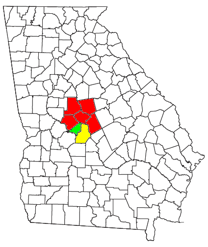
Municipalities and communities of Monroe County, Georgia Cities Culloden | Forsyth
Unincorporated
communitiesBolingbroke | Juliette | Smarr
Macon-Warner Robins-Fort Valley Combined Statistical Area Principal cities 
Municipalities Allentown • Byron • Centerville • Culloden • Danville • Forsyth • Gray • Jeffersonville • Perry • RobertaOther
communitiesAvondale • Bolingbroke • Bonaire • Clinchfield • Dunbar • Elberta • Elko • Franklinton • Haddock • Juliette • Kathleen • Knoxville • Lizella • Musella • Robins AFB • Sofkee • Smarr • WaldenCounties CSA
componentsMacon Metropolitan Statistical Area • Warner Robins Metropolitan Statistical Area • Fort Valley Micropolitan Statistical AreaCategories:- Cities in Georgia (U.S. state)
- Populated places in Monroe County, Georgia
- Populated places in Georgia (U.S. state) with African American majority populations
- Macon metropolitan area


Wikimedia Foundation. 2010.