- Cordele, Georgia
-
Cordele, Georgia — City — Crisp County Courthouse, Cordele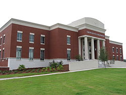 Location in Crisp County and the state of Georgia
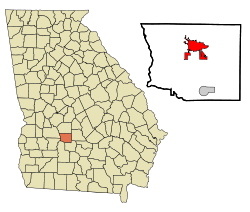
Coordinates: 31°57′51″N 83°46′38″W / 31.96417°N 83.77722°WCoordinates: 31°57′51″N 83°46′38″W / 31.96417°N 83.77722°W Country United States State Georgia County Crisp Area - Total 9.6 sq mi (24.8 km2) - Land 9.5 sq mi (24.6 km2) - Water 0.1 sq mi (0.2 km2) Elevation 315 ft (96 m) Population (2000) - Total 11,608 - Density 1,209.2/sq mi (468.1/km2) Time zone Eastern (EST) (UTC-5) - Summer (DST) EDT (UTC-4) ZIP codes 31010, 31015 Area code(s) 229 FIPS code 13-19616[1] GNIS feature ID 0312971[2] Website http://www.cityofcordele.com/ Cordele, also known as The Watermelon Capital of the World,[1] is a city in Crisp County, Georgia, United States. The population was 11,608 at the 2000 census. The city is the county seat of Crisp County[3]. Cordele is located along Interstate 75, 140 miles south of Atlanta and 100 miles north of the Florida state line.
Contents
History
In November 1864 the area that is now Cordele served as the temporary capital of Georgia. During the last days of the Confederacy, Georgia's war governor Joseph E. Brown used his rural farm house to escape the wrath of Sherman's "March to the Sea." During that time the farm house which Brown called "Dooly County Place" served as the official capital for only a few days. It was replaced in 1890 by the Suwanee Hotel[2], located in what became downtown Cordele. The hotel was destroyed by a fire in late 1994 and was rebuilt.
The small town of Cordele, GA was founded in the southern part of Dooly County in 1888 by J.E.D. Shipp of Americus. The city of Cordele was incorporated on December 22, 1888. It drew great benefits from the presence of two major railroads-the Savannah, Americus & Montgomery line and the Georgia Southern and Florida. It was named after Cordelia Hawkins, daughter of the president of the SAM railroad, and the town flourished from the junction of the two railroads.
As the railroads brought more people and business to the newly settled territory, Cordele was experiencing phenomenal growth. Before 1905 Cordele was located in southern Dooly County nine miles from the county seat in Vienna. With Cordele's continued progress, many in the community felt the need for a seat of government to be closer in proximity than Vienna. Crisp County was formed in 1905 by taking a portion of southern Dooly County and Cordele became its county seat.
By August 1930, Cordele housed the first county-owned electric system[3] in the form of the Crisp County Hydroelectric System. Located on the Flint River, the hydroelectric plant continues to operate and the resulting Lake Blackshear has attracted residents to its water-front properties. On April 2, 1936 a tornado struck Cordele killing 23 persons.
In 1968 a Titan I missile was erected at the intersection of I-75 and U.S. 280 East,[4] where there is also a Krystal restaurant.
Geography
Cordele is located at 31°57′51″N 83°46′38″W / 31.96417°N 83.77722°W (31.964178, -83.777277)[4].
According to the United States Census Bureau, the city has a total area of 9.6 square miles (25 km2), of which, 9.5 square miles (25 km2) of it is land and 0.1 square miles (0.26 km2) of it (0.84%) is water.
Major highways
 Interstate 75 / SR 401
 U.S. Route 41 /
  State Route 7
 U.S. Route 280 /
  State Route 30
 State Route 33
 State Route 90
 State Route 257
 State Route 300 (Georgia-Florida Parkway)
Demographics
As of the census[1] of 2000, there were 11,608 people, 4,303 households, and 2,839 families residing in the city. The population density was 1,222.5 people per square mile (471.8/km²). There were 4,782 housing units at an average density of 503.6 per square mile (194.4/km²). The racial makeup of the city was 31.90% White, 65.03% African American, 0.06% Native American, 0.84% Asian, 0.06% Pacific Islander, 1.19% from other races, and 0.91% from two or more races. Hispanic or Latino of any race were 1.95% of the population.
There were 4,303 households out of which 35.4% had children under the age of 18 living with them, 31.1% were married couples living together, 30.8% had a female householder with no husband present, and 34.0% were non-families. 30.3% of all households were made up of individuals and 13.9% had someone living alone who was 65 years of age or older. The average household size was 2.59 and the average family size was 3.22.
In the city the population was spread out with 31.6% under the age of 18, 10.2% from 18 to 24, 25.6% from 25 to 44, 18.1% from 45 to 64, and 14.5% who were 65 years of age or older. The median age was 31 years. For every 100 females there were 81.7 males. For every 100 females age 18 and over, there were 74.9 males.
The median income for a household in the city was $17,615, and the median income for a family was $21,677. Males had a median income of $23,253 versus $17,282 for females. The per capita income for the city was $12,746. About 38.1% of families and 41.6% of the population were below the poverty line, including 59.2% of those under age 18 and 26.7% of those age 65 or over.
Education
Crisp County School District
The Crisp County School District holds grades pre-school to grade twelve, that consists of four elementary schools, a middle school, and a high school.[5] The district has 266 full-time teachers and over 4,337 students.[6]
- A. S. Clark Elementary School
- Blackshear Trail Elementary School
- J. S. Pate Elementary School
- Southwestern Elementary School
- Crisp County Middle School
- Crisp County High School
Notable Cordelians
- Jazz singer and "Cosby Show" grandfather, Joe Williams.
- Buster Brown, Blues and R&B singer
- Jody Powell, who served as the White House Press Secretary under President Jimmy Carter.
- Mac Hyman, author of No Time for Sergeants and Take Now Thy Son was a life long resident of Cordele, GA.
- Tree Rollins, former NBA basketball player and Cordele native who attended Crisp County High School.
- Janie Lou Gibbs, a serial killer, who poisoned her husband, three sons, and grandson. She was convicted in 1967.
- Andre Ramsey, Offensive lineman (#76) for the Buffalo Bills
- T. J. Jackson, Olympian and NFL wide receiver
- Marcus Lamb, President of international Christian TV network Daystar Television Network
References
- ^ a b "American FactFinder". United States Census Bureau. http://factfinder.census.gov. Retrieved 2008-01-31.
- ^ "US Board on Geographic Names". United States Geological Survey. 2007-10-25. http://geonames.usgs.gov. Retrieved 2008-01-31.
- ^ "Find a County". National Association of Counties. http://www.naco.org/Counties/Pages/FindACounty.aspx. Retrieved 2011-06-07.
- ^ "US Gazetteer files: 2010, 2000, and 1990". United States Census Bureau. 2011-02-12. http://www.census.gov/geo/www/gazetteer/gazette.html. Retrieved 2011-04-23.
- ^ Georgia Board of Education, Retrieved June 6, 2010.
- ^ School Stats, Retrieved June 6, 2010.
External links
- City of Cordele -- official site
- Cordele Dispatch -- local newspaper
- AmericusGeorgia.net - Area info... by and for Cordele Locals
- Georgia Veterans State Park
- O’Neal Historic District
Municipalities and communities of Crisp County, Georgia County seat: Cordele City Cordele

Town Categories:- Cities in Georgia (U.S. state)
- Populated places in Crisp County, Georgia
- Micropolitan areas of Georgia (U.S. state)
- County seats in Georgia (U.S. state)
- Populated places in Georgia (U.S. state) with African American majority populations


Wikimedia Foundation. 2010.