- Citrus Springs, Florida
-
Citrus Springs, Florida — CDP — Location in Citrus County and the state of Florida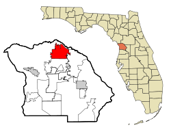
Coordinates: 28°59′37″N 82°27′42″W / 28.99361°N 82.46167°WCoordinates: 28°59′37″N 82°27′42″W / 28.99361°N 82.46167°W Country  United States
State  Florida
County Citrus Area - Total 21.3 sq mi (55.1 km2) - Land 21.3 sq mi (55.1 km2) - Water 0 sq mi (0 km2) Elevation 95 ft (29 m) Population (2000) - Total 4,157 - Density 195.2/sq mi (75.4/km2) Time zone Eastern (EST) (UTC-5) - Summer (DST) EDT (UTC-4) ZIP codes 34433-34434 Area code(s) 352 FIPS code 12-12450[1] GNIS feature ID 0304634[2] Citrus Springs is a census-designated place (CDP) in Citrus County, Florida, United States. The population was 4,157 at the 2000 census.
Contents
Geography
Citrus Springs is located at 28°59′37″N 82°27′42″W / 28.99361°N 82.46167°W (28.993539, -82.461692)[3].
According to the United States Census Bureau, the CDP has a total area of 21.3 square miles (55 km2), all of it land.
Demographics
As of the census[1] of 2000, there were 4,157 people, 1,834 households, and 1,333 families residing in the CDP. The population density was 195.4 people per square mile (75.5/km²). There were 2,003 housing units at an average density of 94.2/sq mi (36.4/km²). The racial makeup of the CDP was 93.70% White, 2.24% African American, 0.31% Native American, 0.65% Asian, 0.07% Pacific Islander, 1.37% from other races, and 1.66% from two or more races. Hispanic or Latino of any race were 5.46% of the population.
There were 1,834 households out of which 20.1% had children under the age of 18 living with them, 62.4% were married couples living together, 8.5% had a female householder with no husband present, and 27.3% were non-families. 23.3% of all households were made up of individuals and 16.4% had someone living alone who was 65 years of age or older. The average household size was 2.25 and the average family size was 2.61.
In the CDP the population was spread out with 18.0% under the age of 18, 4.2% from 18 to 24, 18.6% from 25 to 44, 22.9% from 45 to 64, and 36.3% who were 65 years of age or older. The median age was 54 years. For every 100 females there were 88.4 males. For every 100 females age 18 and over, there were 85.8 males.
The median income for a household in the CDP was $29,758, and the median income for a family was $35,000. Males had a median income of $27,143 versus $18,686 for females. The per capita income for the CDP was $16,845. About 5.0% of families and 7.8% of the population were below the poverty line, including 11.4% of those under age 18 and 4.1% of those age 65 or over.
History
Citrus Springs was developed by the Mackle family, a prominent real estate development family, to be used as a subdivision consisting of over 34,000 homesties. An interesting note is that Elkcam Blvd, a prominent street in Citrus Springs, is actually Mackle backwards. The area currently has 2 elementary schools [Citrus Springs Elementary School and Central Ridge Elementary School, opened fall 2008] and 1 middle school [Citrus Springs Middle School]. There are plans for an 80-acre (320,000 m2) high school campus complete with public park, but construction is not planned in the near future.[4]
Phosphate mining also played a major part in the history of the Citrus County until the end of WWII in which phosphate mining was largely moved overseas. The first newspaper of Citrus County was called the Phosphate Times. Many abandoned mines stretch along the Withlacoochee River basin, with a concentration of those within Citrus Springs. Some of those areas can be seen at one of Citrus Springs two golf courses, El Diablo. Many of those mines were part of the Dunnellon Phosphate company, headed by Capt John L. Inglis, a veteran of the Civil War. Areas near northeastern Citrus Springs, being included as part of a proposed unfinished portion of the Cross Florida Barge Canal to aid the transportation of the mineral.
Citrus Springs features a 46-mile (74 km) bike riding trail known as the Withlacoochee State Trail which was converted from the railroad lines built in the early 1900s.
Tourism Links
Citrus County Visitors & Convention Bureau
References
- ^ a b "American FactFinder". United States Census Bureau. http://factfinder.census.gov. Retrieved 2008-01-31.
- ^ "US Board on Geographic Names". United States Geological Survey. 2007-10-25. http://geonames.usgs.gov. Retrieved 2008-01-31.
- ^ "US Gazetteer files: 2010, 2000, and 1990". United States Census Bureau. 2011-02-12. http://www.census.gov/geo/www/gazetteer/gazette.html. Retrieved 2011-04-23.
- ^ http://www.citrus.k12.fl.us
Municipalities and communities of Citrus County, Florida Cities 
CDPs Beverly Hills | Black Diamond | Citrus Hills | Citrus Springs | Floral City | Hernando | Homosassa | Homosassa Springs | Inverness Highlands North | Inverness Highlands South | Lecanto | Pine Ridge | Sugarmill Woods
Unincorporated
communitiesHolder | Meadowcrest | Pineola | Red Level | Ozello
Categories:- Census-designated places in Citrus County, Florida


Wikimedia Foundation. 2010.