Crimea Pass

Crimea Pass
Crimea Pass

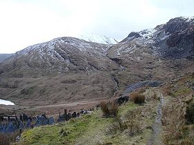
The Pass in 2006
Elevation 385 m (1,263 ft)
Traversed by A470 road
Location
Location North Wales
Coordinates 53°01′24″N 3°56′17″W / 53.02338°N 3.93816°W / 53.02338; -3.93816

The Crimea Pass (Welsh: Bwlch y Gorddinan) is a mountain pass in north Wales, on the A470 road between Blaenau Ffestiniog and Dolwyddelan.

At its highest point, it is 385 metres (1,263 ft) above sea level, and is sometimes closed in winter because of snow. At one time there was an inn at the summit of the pass, popularly known as "the Crimea".

It takes its name from the Crimean War which was being fought about the time the road was opened, in 1854. By repute construction of the stone walls in the area was carried out by Russian prisoners of war captured at the Battles of Inkerman and Balaclava.

In 2008 major highway improvement work on the A470 through the Pass was completed, this including the downhill section to the north of the pass, and southwards down to Blaenau Ffestiniog.

References

External links

Coordinates: 53°01′24″N 3°56′17″W / 53.02338°N 3.93816°W / 53.02338; -3.93816


Wikimedia Foundation. 2010.

Игры ⚽ Нужно решить контрольную?

Look at other dictionaries:

  • Angarskyi Pass — The Angarskyi Pass ( uk. Ангарський перевал; ru. Ангарский перевал; cr. Anğara boğazı) is a mountain pass of the Crimean Mountains on the Crimean peninsula of southern Ukraine. The pass is the highest point on the Simferopol Alushta roadway, at… …   Wikipedia

  • Portal:Crimea — Wikipedia portals: Culture Geography Health History Mathematics Natural sciences People Philosophy Religion Society Technology …   Wikipedia

  • Hymn of Crimea — Гімн Автономної Республіки Крим English: Hymn of the Autonomous Republic of Crimea Regional anthem of Autonomous Republic of Crimea Also known as Гимн Автономной Республики Крым English:  In Russian Qırım Muhtar Cumhuriyetiniñ Gimni… …   Wikipedia

  • Battle of the Dukla Pass — Part of the Eastern Front of World War II Date 8 September – 28 October 1944 Location Dukla Pass, present day Slovakia …   Wikipedia

  • A470 road — UK road routebox caption= Gabalfa flyover at the interchange with the A48 in Cardiff road= A470 length mi= length km= direction= South North start= Cardiff Bay destinations= Cardiff Merthyr Tydfil Brecon Builth Wells Dolgellau end= Llandudno… …   Wikipedia

  • Moel Penamnen — from Manod Mawr Elevation 623 m (2,044 ft) …   Wikipedia

  • Blaenau Ffestiniog — infobox UK place country = Wales welsh name= constituency welsh assembly= latitude= 52.99 longitude= 3.93 official name= Blaenau Ffestiniog population = 4830 unitary wales= Gwynedd lieutenancy wales= Gwynedd constituency westminster= Meirionnydd… …   Wikipedia

  • Lledr Valley — The Lledr Valley ( cy. Dyffryn Lledr) is a valley in Snowdonia in north Wales. It runs from the top of the Crimea Pass, north of Blaenau Ffestiniog down to Betws y coed.The A470 road follows the line of the valley, as does the railway line from… …   Wikipedia

  • Russia — /rush euh/, n. 1. Also called Russian Empire. Russian, Rossiya. a former empire in E Europe and N and W Asia: overthrown by the Russian Revolution 1917. Cap.: St. Petersburg (1703 1917). 2. See Union of Soviet Socialist Republics. 3. See Russian… …   Universalium

  • November 2006 in sports — See also: 2006 in sports << November 2006 >> S M T W T F S …   Wikipedia

Share the article and excerpts

Direct link
Do a right-click on the link above
and select “Copy Link”