- Moel Penamnen
-
Moel Penamnen 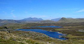
Moel Penamnen from Manod MawrElevation 623 m (2,044 ft) Prominence c. 133 m Listing Hewitt, Nuttall Location Location Gwynedd,  Wales
WalesRange Moelwynion Topo map OS Landranger 115 OS grid SH716483 Moel Penamnen is a mountain just north of Blaenau Ffestiniog, North Wales and forms part of the Moelwynion.
It may be climbed from the Crimea Pass via Moel Farwlyd, from Blaenau Ffestiniog or Cwm Penamnen to the north. A circular of Cwm Penamnen can be done taking in Y Ro Wen. It may also be combined with its parent peak Manod Mawr, however the pass between these peaks is extremely boggy and there are many mines, air shafts and open quarries in the area.[1]
References
- ^ Nuttall, John & Anne (1999). The Mountains of England & Wales - Volume 1: Wales (2nd edition ed.). Milnthorpe, Cumbria: Cicerone. ISBN 1-85284-304-7.
External links
Coordinates: 53°01′00″N 3°54′56″W / 53.01655°N 3.91549°W
Categories:- Hewitts of Wales
- Mountains and hills of Snowdonia
- Nuttalls
- Gwynedd geography stubs

Wikimedia Foundation. 2010.