- Little Grass Valley, California
Infobox Settlement
official_name = Little Grass Valley, California
other_name =
native_name =
nickname =
settlement_type = CDP
motto =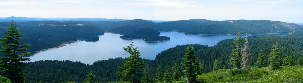
imagesize =
image_caption = Little Grass Valley Reservoir as seen from atop nearby Bald Mountain
flag_size =
image_
seal_size =
image_shield =
shield_size =
image_blank_emblem =
blank_emblem_type =
blank_emblem_size =
flag_size =
image_
seal_size =
image_shield =
shield_size =
image_blank_emblem =
blank_emblem_type =
blank_emblem_size =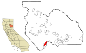
mapsize = 250x200px
map_caption = Location in Plumas County and the state ofCalifornia
mapsize1 =
map_caption1 =
image_dot_
dot_mapsize =
dot_map_caption =
dot_x =
dot_y =
pushpin_
pushpin_label_position =
pushpin_map_caption =
pushpin_mapsize =
subdivision_type = Country
subdivision_name =United States
subdivision_type1 = State
subdivision_name1 =California
subdivision_type2 = County
subdivision_name2 = Plumas
subdivision_type3 =
subdivision_name3 =
subdivision_type4 =
subdivision_name4 =
government_footnotes =
government_type =
leader_title =
leader_name =
leader_title1 =
leader_name1 =
leader_title2 =
leader_name2 =
leader_title3 =
leader_name3 =
leader_title4 =
leader_name4 =
established_title =
established_date =
established_title2 =
established_date2 =
established_title3 =
established_date3 =
area_magnitude =
unit_pref =
area_footnotes =
area_total_km2 = 25.2
area_land_km2 = 25.2
area_water_km2 = 0
area_total_sq_mi = 9.7
area_land_sq_mi = 9.7
area_water_sq_mi = 0
area_water_percent =
area_urban_km2 =
area_urban_sq_mi =
area_metro_km2 =
area_metro_sq_mi =
area_blank1_title =
area_blank1_km2 =
area_blank1_sq_mi =
population_as_of = 2000
population_footnotes =
population_note =
population_total = 0
population_density_km2 = 0.0
population_density_sq_mi = 0.0
population_metro =
population_density_metro_km2 =
population_density_metro_sq_mi =
population_urban =
population_density_urban_km2 =
population_density_urban_sq_mi =
population_blank1_title =
population_blank1 =
population_density_blank1_km2 =
population_density_blank1_sq_mi =
timezone = Pacific (PST)
utc_offset = -8
timezone_DST = PDT
utc_offset_DST = -7
latd = 39 |latm = 42 |lats = 59 |latNS = N
longd = 120 |longm = 58 |longs = 35 |longEW = W
elevation_footnotes =
elevation_m =
elevation_ft =
postal_code_type =ZIP code
postal_code = 96053
area_code = 530
blank_name = FIPS code
blank_info = 06-41789
blank1_name =
blank1_info =
website =
footnotes =Little Grass Valley is a lake located in
Plumas County, California , USA. As of the 2000 census, thecensus-designated place had a totalpopulation of 0.Geography
Little Grass Valley is located at 39°42'59" North, 120°58'35" West (39.716311, -120.976287)GR|1.
According to the
United States Census Bureau , the town has a total area of 9.7 square miles (25.2 km²). Although the Bureau states there is no water, the lake covers about 1600 acres (6.5 km² or 2.5 sq mi).Demographics
Little Grass Valley was initially occupied by the
Maidu Native American tribe during the summers. During theCalifornia Gold Rush , it became a mining camp. The camp disappeared before 1900, but there are still gold mines in the area. The land in the valley was used to graze cattle and there was a Boy Scout Camp located on the banks of the South Fork of the Feather River. In 1963 the whole area was flooded and a lake filled the valley. Today there are campgrounds all around the lake, cabins on the south side, and it is the center of a snowmobiling area. It is about three miles from La Porte (population 43).Politics
In the state legislature Little Grass Valley is located in the 1st Senate District, represented by Republican
Dave Cox , and in the 3rd Assembly District, represented by RepublicanRick Keene . Federally, Little Grass Valley is located inCalifornia's 4th congressional district , which has a Cook PVI of R +11 [cite web | title = Will Gerrymandered Districts Stem the Wave of Voter Unrest? | publisher = Campaign Legal Center Blog | url=http://www.clcblog.org/blog_item-85.html | accessdate = 2007-10-20] and is represented by RepublicanJohn Doolittle .Fowler Lake
About 2.5 miles north of Little Grass Valley lake lies a small, natural lily pond called Fowler Lake. Its latitude and longitude coordinates are 39.4627, -121.0050 and the altitude is 5446 feet (1660 meters).
References
ources
* [http://www.shastacascade.org/forest/plumas/water.htm#GRASS "Little Grass Valley Lake Recreation Area"]
External links
Wikimedia Foundation. 2010.