- Denning, Arkansas
-
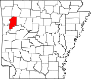
Denning, Arkansas — Town — Location in Franklin County and the state of Arkansas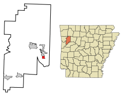
Coordinates: 35°25′46″N 93°45′23″W / 35.42944°N 93.75639°WCoordinates: 35°25′46″N 93°45′23″W / 35.42944°N 93.75639°W Country United States State Arkansas County Franklin Area – Total 1.1 sq mi (2.9 km2) – Land 1.1 sq mi (2.9 km2) – Water 0 sq mi (0 km2) Elevation 453 ft (138 m) Population (2000) – Total 270 – Density 245.5/sq mi (93.1/km2) Time zone Central (CST) (UTC-6) – Summer (DST) CDT (UTC-5) FIPS code 05-18370 GNIS feature ID 0048468 Denning is a town in Franklin County, Arkansas, United States. It is part of the Fort Smith, Arkansas-Oklahoma Metropolitan Statistical Area. The population was 270 at the 2000 census.
Geography
Denning is located at 35°25′46″N 93°45′23″W / 35.42944°N 93.75639°W (35.429513, -93.756365)[1].
According to the United States Census Bureau, the town has a total area of 2.8 km² (1.1 mi²), all land. It sustained a direct hit from a tornado during the Late-May 2011 tornado outbreak.
Demographics
As of the census[2] of 2000, there were 270 people, 102 households, and 75 families residing in the town. The population density was 94.8/km² (244.8/mi²). There were 115 housing units at an average density of 40.4/km² (104.3/mi²). The racial makeup of the town was 95.19% White, 0.37% Black or African American, 0.74% Native American, 1.85% Asian, and 1.85% from two or more races. 2.22% of the population were Hispanic or Latino of any race.
There were 102 households out of which 33.3% had children under the age of 18 living with them, 60.8% were married couples living together, 5.9% had a female householder with no husband present, and 25.5% were non-families. 22.5% of all households were made up of individuals and 12.7% had someone living alone who was 65 years of age or older. The average household size was 2.65 and the average family size was 3.04.
In the town the population was spread out with 26.3% under the age of 18, 6.7% from 18 to 24, 28.9% from 25 to 44, 20.0% from 45 to 64, and 18.1% who were 65 years of age or older. The median age was 39 years. For every 100 females there were 100.0 males. For every 100 females age 18 and over, there were 97.0 males.
The median income for a household in the town was $23,750, and the median income for a family was $32,708. Males had a median income of $19,792 versus $17,344 for females. The per capita income for the town was $12,487. About 22.8% of families and 21.8% of the population were below the poverty line, including 18.4% of those under the age of eighteen and 9.8% of those sixty five or over.
References
- ^ "US Gazetteer files: 2010, 2000, and 1990". United States Census Bureau. 2011-02-12. http://www.census.gov/geo/www/gazetteer/gazette.html. Retrieved 2011-04-23.
- ^ "American FactFinder". United States Census Bureau. http://factfinder.census.gov. Retrieved 2008-01-31.
Municipalities and communities of Franklin County, Arkansas Cities Altus | Branch | Charleston | Ozark | Wiederkehr Village
Town Denning
Unincorporated
communitiesAlix | Cecil
Categories:- Populated places in Franklin County, Arkansas
- Towns in Arkansas
- Fort Smith metropolitan area


Wikimedia Foundation. 2010.