- Nankoweap Trail
-
Nankoweap Trail Length 13.9 mi (22 km) Location Grand Canyon National Park, Arizona, United States Trailheads North Rim
Colorado River,
Grand Canyon (North Rim)Use Hiking
BackpackingElevation Change 6,040 ft (1,841 m) Highest point North Rim, 8,840 ft (2,694 m) Lowest point Colorado River, 2,800 ft (853 m) Trail difficulty Expert
(unmaintained)Season Early Spring to
Late FallSights Grand Canyon
Colorado River
Puebloan granariesHazards Severe Weather
Overexertion
Dehydration
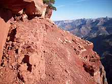
Flash FloodThe Nankoweap Trail is a hiking trail on the North Rim of the Grand Canyon National Park, located in the U.S. state of Arizona. The Nankoweap trail descends 6,040 feet in 14 miles from the Saddle Mountain trailhead to Nankoweap Creek and on to the Colorado River. It is considered to be the hardest of the trails into the Canyon. You have to carry and cache water as there is none in the 11 miles between the trailhead and Nankoweap Creek. "The Scary Part" is a section that is 6 inches wide under a sheer cliff with a couple of hundred foot drop punishing the slightest misstep. Getting across "The Scary Part" with a full pack is a serious challenge.
Thought to be an Ancestral Puebloan trail, John Wesley Powell supervised the development of the Nankoweap Trail in 1882 as a means to allow geologists access to the area. Interest in the trail revived after Harvey Butchart described it in his 1970 Grand Canyon Treks trail guide.[1]
Contents
See also
References
- ^ Nankoweap Trail by Alan English
Further reading
- John Annerino, 2006, Hiking the Grand Canyon. Sierra Club Books, 3rd ed., ISBN 1578051509
External links
- Nankoweap Trail at HikeArizona
- Nankoweap Trail at NPS
Coordinates: 36°18′N 111°51′W / 36.30°N 111.85°W
Grand Canyon trails Above-rim Trails: Below-rim Trails: Beamer Trail • Bill Hall Trail • Boucher Trail • Bright Angel Trail • Clear Creek Trail • Deer Creek Trail • Dripping Springs Trail • Escalante Route • Esplanade Route • Grandview Trail • Havasupai Trail • Hermit Trail • Kanab Creek Trail • Lava Falls Trail • Nankoweap Trail • New Hance Trail • North Bass Trail • North Kaibab Trail • Plateau Point Trail • River Trail • Royal Arch Route • South Bass Trail • South Canyon Trail • South Kaibab Trail • Tanner Trail • Thunder River Trail • Tonto Trail • Tuckup Trail • Waldron TrailCategories:- Hiking trails in Grand Canyon National Park
- Arizona geography stubs
- United States trail stubs
Wikimedia Foundation. 2010.

