- Chatom, Alabama
-
Chatom, Alabama — Town — Washington County Courthouse in Chatom, Alabama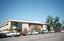 Location in Washington County and the state of Alabama
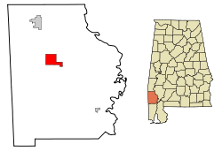
Coordinates: 31°27′41″N 88°14′52″W / 31.46139°N 88.24778°WCoordinates: 31°27′41″N 88°14′52″W / 31.46139°N 88.24778°W Country United States State Alabama County Washington Area - Total 10.9 sq mi (28.2 km2) - Land 10.9 sq mi (28.2 km2) - Water 0 sq mi (0 km2) Elevation 210 ft (64 m) Population (2000) - Total 1,193 - Density 109.4/sq mi (42.3/km2) Time zone Central (CST) (UTC-6) - Summer (DST) CDT (UTC-5) ZIP code 36518 Area code(s) 251 FIPS code 01-14008 GNIS feature ID 0115982 Website http://www.chatom.org/ Chatom is a town in Washington County, Alabama, United States. At the 2000 census the population was 1,193. The city is the county seat of Washington County[1].
Geography
Chatom is located at 31°27′42″N 88°14′53″W / 31.461656°N 88.248051°W.[2]
According to the U.S. Census Bureau, the town has a total area of 10.9 square miles (28 km2), all land.
Demographics
As of the census[3] of 2000, there were 1,193 people, 449 households, and 308 families residing in the town. The population density was 109.7 people per square mile (42.3/km2). There were 523 housing units at an average density of 48.1 per square mile (18.6/km2). The racial makeup of the town was 67.23% White, 32.10% Black or African American, 0.42% Native American, 0.08% from other races, and 0.17% from two or more races. 0.50% of the population were Hispanic or Latino of any race.
There were 449 households out of which 38.1% had children under the age of 18 living with them, 48.6% were married couples living together, 18.0% had a female householder with no husband present, and 31.4% were non-families. 28.7% of all households were made up of individuals and 15.4% had someone living alone who was 65 years of age or older. The average household size was 2.48 and the average family size was 3.10.
In the town the population was spread out with 27.9% under the age of 18, 9.1% from 18 to 24, 23.9% from 25 to 44, 19.3% from 45 to 64, and 19.9% who were 65 years of age or older. The median age was 35 years. For every 100 females there were 83.8 males. For every 100 females age 18 and over, there were 73.4 males.
The median income for a household in the town was $31,319, and the median income for a family was $41,563. Males had a median income of $36,518 versus $19,750 for females. The per capita income for the town was $16,650. About 17.3% of families and 23.5% of the population were below the poverty line, including 34.4% of those under age 18 and 20.9% of those age 65 or over.
References
- ^ "Find a County". National Association of Counties. http://www.naco.org/Counties/Pages/FindACounty.aspx. Retrieved 2011-06-07.
- ^ "US Gazetteer files: 2010, 2000, and 1990". United States Census Bureau. 2011-02-12. http://www.census.gov/geo/www/gazetteer/gazette.html. Retrieved 2011-04-23.
- ^ "American FactFinder". United States Census Bureau. http://factfinder.census.gov. Retrieved 2008-01-31.
Municipalities and communities of Washington County, Alabama Towns 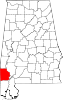
CDPs Deer Park | Leroy | St. Stephens | Vinegar Bend
Categories:- Towns in Alabama
- Populated places in Washington County, Alabama
- County seats in Alabama


Wikimedia Foundation. 2010.