- Namur, Wisconsin
-
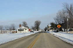
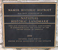
Namur, Wisconsin — Unincorporated community — Looking east in downtown Namur Location within the state of Wisconsin Coordinates: 44°44′3″N 87°40′11″W / 44.73417°N 87.66972°WCoordinates: 44°44′3″N 87°40′11″W / 44.73417°N 87.66972°W Country United States State Wisconsin County Door City Union Time zone Central (CST) (UTC-6) - Summer (DST) CDT (UTC-5) ZIP codes FIPS code GNIS feature ID Namur, Wisconsin is an unincorporated community in the Town of Union in Door County, Wisconsin.[1] The community is located on Wisconsin Highway 57 at its intersection with County Road N. It is located approximately 5 miles west of the unincorporated community of Brussels, Wisconsin. The community is located inside the Namur Historic District, a historic district of farms near the community.
Images
-
Looking northeast on the former Wisconsin Highway 57
References
Municipalities and communities of Door County, Wisconsin County seat: Sturgeon Bay City Villages Towns Baileys Harbor | Brussels | Clay Banks | Egg Harbor | Forestville | Gardner | Gibraltar | Jacksonport | Liberty Grove | Nasewaupee | Sevastopol | Sturgeon Bay | Union | Washington
CDPs Baileys Harbor | Ellison Bay | Little Sturgeon
Unincorporated
communitiesBrussels | Carlsville | Carnot | Detroit Harbor | Fish Creek | Gills Rock | Idlewild | Institute | Jacksonport | Juddville | Kolberg | Maplewood | Namur | North Bay | Northport | Peninsula Center | Rosiere‡ | Rowleys Bay | Salona | Shoemaker Point | Valmy | Vignes | Washington | West Jacksonport | Whitefish Bay
Footnotes ‡This populated place also has portions in an adjacent county or counties
Categories:- Wisconsin geography stubs
- Unincorporated communities in Wisconsin
- Populated places in Door County, Wisconsin
Wikimedia Foundation. 2010.


