- San Francisco Plaza, New Mexico
-
San Francisco Plaza, New Mexico — Unincorporated area — Location of San Francisco Plaza, New Mexico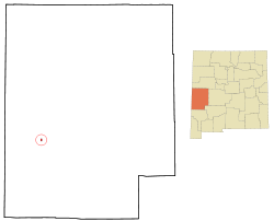
Country United States State New Mexico County Catron Population (2000) – Total 0 Time zone Mountain (MST) (UTC-5) – Summer (DST) MDT (UTC) Area code(s) 575 GNIS feature ID 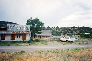 The Frisco Store in Lower Frisco Plaza
San Francisco Plaza was name of three towns in Catron County, New Mexico, United States. Located in the San Francisco River Valley, the towns were settled by Spanish settlers in the 1860s. Today Middle San Francisco Plaza is almost non-existent; Lower San Francisco is called "Lower Frisco" and Upper San Francisco was renamed Reserve when U.S. Forest Service headquarters were built there.
About
Located in the San Francisco Valley, Reserve was named Upper San Francisco Plaza by its original Hispanic settlers in 1874. Apaches made frequent attacks on the community, which sit within Apache hunting lands.[1] In the late 1870s Anglo settlers began arriving. They renamed Upper Frisco Plaza as Milligan's Plaza after a town merchant and saloon owner.
Lower San Francisco Plaza was the site of the legendary Frisco Shootout of Elfego Baca in 1884. The self-appointed deputy sheriff made a stand-off against a mob of Texas cowboys in Lower San Francisco Plaza in 1884,[2] quickly gaining a reputation as the hero of the Frisco Shootout. Author Louis L'Amour included Upper San Francisco Plaza in his novel Conagher, calling it "The Plaza".[3] The Tularosa River flows into the San Francisco River at Middle San Francisco Plaza.
References
- ^ Collier, H.P. (1936) San Francisco Plaza, Catron County: Brief history. Workers Progress Administration. Retrieved 6/12/07.
- ^ Carter, R. (2004) SouthWestSlide: A journal of a journey across Desert Rat country. Retrieved 6/12/07.
- ^ (nd) Louis L'Amour's New Mexico TheHistoryNet.com. Retrieved 6/12/07.
External links
- Elfego Baca & The “Frisco War”. Legends of America website.
- Frisco, New Mexico, GhostTowns.com entry by Samuel W McWhorter.
Topics of Catron County, New Mexico Natural features Aspen Mountain · Jordan Hot Springs · Middle Fork Hot Springs · Mogollon-Datil volcanic field · Mogollon Mountains · Plains of San Agustin · Red Hill volcanic field · San Francisco River · Turkey Creek Hot Springs · Whitewater Baldy
Protected areas Blue Range Wilderness · Catwalk National Recreation Trail · Gila National Forest · Gila Wilderness · Whitewater Canyon National Forest Recreation Area
National Register of Historic
Places listingsBearwallow Park · Bearwallow Mountain Lookout Cabins and Shed · Black Mountain · Black Mountain Lookout Cabin · Ake Site · El Caso Lake · El Caso Lookout Complex · Bat Cave · Mangas Mountain Lookout Complex · Mogollon Historic District · Socorro Mines Mining Company Mill, Fannie Hill · Mogollon Baldy Lookout Cabin · Red Hill · Mogollon Pueblo · Zuni Salt Lake
Historic places and events Municipalities and communities of Catron County, New Mexico Village 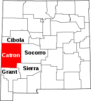
Unincorporated
communitiesAlma | Apache Creek | Cruzville | Datil | Glenwood | Luna | Old Horse Springs | Pie Town | Pleasanton | Quemado | San Francisco Plaza
Ghost towns Coordinates: 33°41′36″N 108°45′58″W / 33.69333°N 108.76611°W
Categories:- Former place names
- Geography of Catron County, New Mexico
- Unincorporated communities in New Mexico
- History of Catron County, New Mexico


Wikimedia Foundation. 2010.