- Davis Lake volcanic field
-
Davis Lake volcanic field 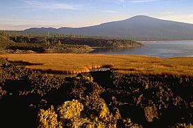
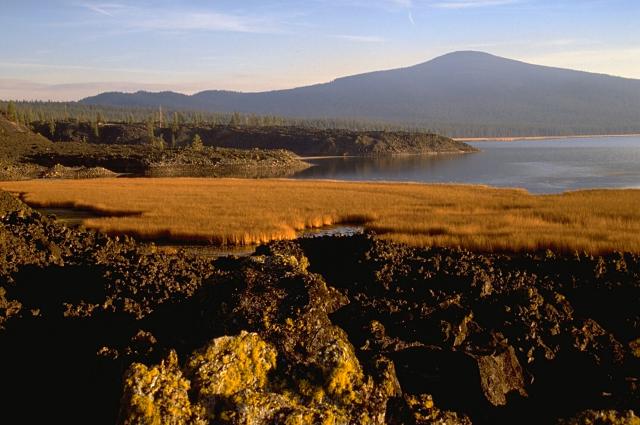
Elevation 2,163 m (7,096 ft) [1] Location Location Deschutes / Klamath counties, Oregon, USA Range Cascades Coordinates 43°34′N 121°49′W / 43.567°N 121.817°WCoordinates: 43°34′N 121°49′W / 43.567°N 121.817°W [1] Geology Type Cinder cone, Lava flow, and Shield volcano [1] Volcanic arc/belt Cascade Volcanic Arc [1] Last eruption 2790 BC (?) [1] The Davis Lake volcanic field, is a volcanic field with a group of andesitic cinder cones, lava flows and basaltic andesite shield volcanos east of the Cascade Range of Oregon, USA.[1]
Notable vents
Name Elevation Coordinates Last eruption Cryder Butte[2] 1,670 meters (5,479 ft) 43°33′49″N 121°43′02″W / 43.5637340°N 121.7172483°W[3] - Davis Mountain[2] 2,019 meters (6,624 ft) 43°37′45″N 121°46′00″W / 43.6292878°N 121.7666941°W[4] - Hamner Butte[2] 2,163 meters (7,096 ft) 43°33′37″N 121°48′44″W / 43.5604009°N 121.8122497°W[5] - Little Odell Butte[2] 1,689 meters (5,541 ft) 43°26′37″N 121°54′17″W / 43.4437368°N 121.9047501°W[6] - Odell Butte[2] 2,137 meters (7,011 ft) 43°28′15″N 121°51′50″W / 43.4709584°N 121.8639165°W[7] - Pine Butte[2] 1,597 meters (5,240 ft) 43°39′41″N 121°50′43″W / 43.6615099°N 121.8453067°W[8] - Ringo Butte[2] 1,853 meters (6,079 ft) 43°32′59″N 121°45′18″W / 43.5498453°N 121.7550265°W[9] - Royce Mountain[2] 1,874 meters (6,148 ft) 43°31′11″N 121°54′08″W / 43.5198466°N 121.9022509°W[10] - See also
References
- ^ a b c d e f "Davis Lake". Global Volcanism Program, Smithsonian Institution. http://www.volcano.si.edu/world/volcano.cfm?vnum=1202-10-. Retrieved 2008-08-20.
- ^ a b c d e f g h "Davis Lake - Synonyms and Subfeatures". Global Volcanism Program, Smithsonian Institution. http://www.volcano.si.edu/world/volcano.cfm?vnum=1202-10-&volpage=synsub. Retrieved 2009-01-07.
- ^ "Cryder Butte". Geographic Names Information System, U.S. Geological Survey. http://geonames.usgs.gov/pls/gnispublic/f?p=gnispq:3:::NO::P3_FID:1140504.
- ^ "Davis Mountain". Geographic Names Information System, U.S. Geological Survey. http://geonames.usgs.gov/pls/gnispublic/f?p=gnispq:3:::NO::P3_FID:1140668.
- ^ "Hamner Butte". Geographic Names Information System, U.S. Geological Survey. http://geonames.usgs.gov/pls/gnispublic/f?p=gnispq:3:::NO::P3_FID:1143253.
- ^ "Little Odell Butte". Geographic Names Information System, U.S. Geological Survey. http://geonames.usgs.gov/pls/gnispublic/f?p=gnispq:3:::NO::P3_FID:1145218.
- ^ "Odell Butte". Geographic Names Information System, U.S. Geological Survey. http://geonames.usgs.gov/pls/gnispublic/f?p=gnispq:3:::NO::P3_FID:1147154.
- ^ "Pine Butte". Geographic Names Information System, U.S. Geological Survey. http://geonames.usgs.gov/pls/gnispublic/f?p=gnispq:3:::NO::P3_FID:1147681.
- ^ "Ringo Butte". Geographic Names Information System, U.S. Geological Survey. http://geonames.usgs.gov/pls/gnispublic/f?p=gnispq:3:::NO::P3_FID:1148477.
- ^ "Royce Mountain". Geographic Names Information System, U.S. Geological Survey. http://geonames.usgs.gov/pls/gnispublic/f?p=gnispq:3:::NO::P3_FID:1148820.
Categories:- Volcanism of Oregon
- Cinder cones of the United States
- Shield volcanoes
- Subduction volcanoes
- Cascade Volcanoes
- Volcanoes of Oregon
- Landforms of Klamath County, Oregon
- Landforms of Deschutes County, Oregon
- Oregon geography stubs
Wikimedia Foundation. 2010.