- Davis Lake
-
Davis Lake 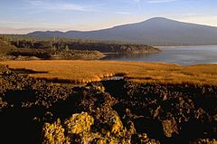
Davis Lake Location Deschutes National Forest, Klamath County, Oregon Coordinates 43°36′57″N 121°50′39″W / 43.61583°N 121.84417°WCoordinates: 43°36′57″N 121°50′39″W / 43.61583°N 121.84417°W Primary inflows Odell Creek
Ranger CreekPrimary outflows Unknown Basin countries United States Surface area 1,000 acres (400 ha) to 3,906 acres (1,581 ha) Average depth 9 ft (2.7 m) Max. depth 22 ft (6.7 m) Surface elevation 3,386 ft (1,032 m) Davis Lake is a lake in Klamath County, Oregon, United States. A relatively large and shallow lake in the Deschutes National Forest, it is located toward the south end of the Cascade Lakes Scenic Byway, near Oregon Route 58 and U.S. 97. The lake is known as one of Oregon's best bass lakes.[1]
History
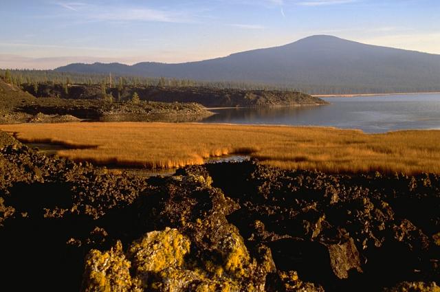
Davis Lake was formed by a lava flow within the nearby volcanic field blocking Odell Creek.[2] The blockage results in the lake, which can cover over 3,000 acres in the winter months. In the summer, however, the inflow from Odell and Ranger creeks cannot fill up the lake as fast as the water escapes through the lava blockage, resulting in the lake covering a much smaller area. It is unknown where the water goes that escapes through the lava dam.[2]
Davis Lake is known for its fishing. Only fly fishing with artificial flies is permitted. Rainbow Trout are planted to assist natural reproduction. The piscivorous trout, native to the lake, feeds on the invasive Tui Chub.[3]
In the 1980s and 1990s, years of drought lowered the levels and warmed the waters of the lake, affecting the trout, which thrive during high-water years. In 1995, largemouth bass were illegally put into the lake, feeding off of the smaller trout. Now, the bass population is greater than the trout population.[1]
Amenities
Davis Lake is a fly-fishing lake only. Motors are allowed, but trolling is illegal. Speed is limited to 10 mph (16 km/h). There is one boat ramp.
There are three campgrounds on the shores of the lake—one each on the west and east sides, and one near the lava flow—which comprise 70 individual campsites. All three campgrounds provide firepits, picnic tables, and toilets, and the east and west side campgrounds provide water.[2]
References
- ^ a b Santella, Chris (22 September 2007). "Once a Trout Fishery, Oregon Lake Has Identity Tied to Bass". The New York Times. p. 6. http://www.nytimes.com/2007/09/22/sports/othersports/22outdoors.html?fta=y. Retrieved 9 August 2011.
- ^ a b c "Davis Lake". Travel Oregon. 2011. http://www.traveloregon.com/Explore-Oregon/Central-Oregon/Outdoor-Recreation/Fishing/Fishing/Davis-Lake.aspx. Retrieved 9 August 2011.
- ^ "Davis Lake". Welches, Oregon: The Fly Fishing Shop. http://www.flyfishusa.com/about-our-waters/lakes/davis/davis-lake.htm. Retrieved 9 August 2011.
Categories:- Lakes of Oregon
- Landforms of Klamath County, Oregon
Wikimedia Foundation. 2010.