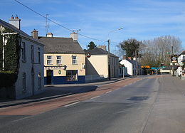
- Milltownpass
-
Milltownpass
Bealach Bhaile an Mhuileann— Town — Location in Ireland Coordinates: 53°26′32″N 7°14′37″W / 53.442161°N 7.243681°WCoordinates: 53°26′32″N 7°14′37″W / 53.442161°N 7.243681°W Country Ireland Province Leinster County County Westmeath Time zone WET (UTC+0) - Summer (DST) IST (WEST) (UTC-1) Irish Grid Reference Milltownpass (Irish: Bealach Bhaile an Mhuileann) is a village in County Westmeath, Ireland. It is located in the south of the county on the R446 regional road formerly the N6 national primary route. The old route was replaced by a dual-carriageway in 2006, bypassing the village. Milltownpass is the second largest village in the parish of Rochfortbridge. It was one of the first villages in Ireland to have its own electricity supply, a mill on the Milltown river providing power to the village long before rural electrification. at the time of writing it has a shop gala
See also
Places in County Westmeath County town: Mullingar Towns and
villagesAthlone · Ballinahown · Ballykeeran · Ballymore · Ballynacargy · Castlepollard · Castletown-Geoghegan · Clonmellon · Collinstown · Coole · Crookedwood · Delvin · Drumcree · Drumraney · Finnea · Fore · Glassan · Horseleap · Kilbeggan · Killucan and Rathwire · Kinnegad · Milltownpass · Moate · Mount Temple · Moyvoughly · Mullingar · Multyfarnham · Raharney · Rathconrath · Rathowen · Rochfortbridge · Rosemount · Streamstown · Street · Tang · Tubberclare · Tyrrellspass
Baronies Brawny · Clonlonan · Corkaree · Delvin · Farbill · Fartullagh · Fore · Kilkenny West · Moyashel and Magheradernon · Moycashel · Moygoish · RathconrathList of townlands in County Westmeath · Category:Geography of County Westmeath Categories:- Untranslated Irish place names
- Towns and villages in County Westmeath
- Ireland geography stubs
Wikimedia Foundation. 2010.


