- Măneşti, Dâmboviţa
-
Măneşti — Commune — Coordinates: 44°58′N 25°17′E / 44.967°N 25.283°ECoordinates: 44°58′N 25°17′E / 44.967°N 25.283°E Country Romania County Dâmboviţa Component villages Drăgăeşti-Pământeni, Drăgăeşti-Ungureni, Măneşti Population (2002) – Total 4,669 Postal code Măneşti is a commune in Dâmboviţa County, Romania, in the valley of the Dâmboviţa River, at a distance of 14 km northwest of Târgovişte.
Contents
Administration
It was formerly part of plasa Voineşti and between 1952 and 1968 it was part of Ploieşti region. In 1968, the current administration was set and since, it is part of Dâmboviţa County.
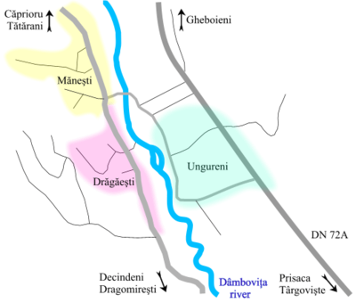
It is composed of three villages: Drăgăeşti-Pământeni (colloquially "Drăgăeşti"), Drăgăeşti-Ungureni (colloquially "Ungureni") and Măneşti. Măneşti and Drăgăeşti are on the right bank of the Dâmboviţa River, while Ungureni is on the left bank.
Name
The name of Măneşti is derived from "Manea" (a Romanian first name), the name of Drăgăeşti from "Drag" (meaning "dear" in Romanian) and the name of Ungureni from "Ungurean" (people from the Hungarian lands, i.e. Transylvania), as Romanians from Transylvania, then ruled by Hungary, settled in this place.
Population
As of 2002[update], it had a population of 4,669. 96.6% of inhabitants were of Romanian ethnicity; 3.4% were Roma (Gypsies), concentrated in the village of Drăgăeşti. In 1924, it had a population of 3,123.
Economy
Most people are farmers, among the crops are apples and pears, as well as maize and wheat. A part of the inhabitants commute to Târgovişte, which is the closest city. Also, there used to be some petroleum extraction in the region, but the resources ended. In Ungureni, there was also a petroleum storage depot, but it was disbanded in the 1990s.
Nearby localities
- Căprioru (North-West)
- Decindeni (South-West)
- Dragomireşti (South)
- Gheboieni (North-East)
- Prisaca (South-East)
- Tătărani (North-West)
References
Categories:- Communes in Dâmboviţa County
- Dâmboviţa County geography stubs
Wikimedia Foundation. 2010.


