- Cerdanya
-
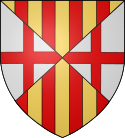 Coat of arms of Cerdagne.
Cerdanya (Catalan pronunciation: [sərˈðaɲə], Latin: Ceretania, French: Cerdagne, Spanish: Cerdaña) is a natural comarca and historical region of the eastern Pyrenees divided between France and Spain. Historically it has been one of the counties of Catalonia.
Cerdanya has a land area of 1,086 km2 (419 sq mi), divided almost evenly between Spain (50.3%) and France (49.7%). In 2001 its population was approximately 26,500, of whom 53% lived on Spanish territory. Its population density of 24 residents per km² (63 per sq. mile) is one of the lowest in Western Europe. The only urban area in Cerdanya is the cross-border urban area of Puigcerdà-Bourg-Madame, which contained 10,900 inhabitants in 2001.
The area enjoys a high annual amount of sunshine – around 3,000 hours per year. For this reason, pioneering large-scale solar power projects have been built in several locations in French Cerdagne, including Font-Romeu-Odeillo-Via, the Themis plant near Targassonne, and Mont-Louis Solar Furnace in Mont-Louis.
Contents
Antiquity
The first inhabitants of Cerdanya probably spoke a language related to the old Basque language and to Aquitanian. Many place names testify to this. In the first millennium BC came the Iberians from the south. Although their identity is still a matter of debate, some theories posit that they spoke an Afro-Asiatic language, and that they separated from the Berbers in North Africa and moved into Spain and then further north to the south of modern-day France.
In Cerdanya they mixed with the native inhabitants, and the resulting people were known as the Kerretes, from the native word ker or kar, meaning rock, related to old Basque karri (modern Basque harri), stone. The Kerretes were probably essentially of Basque and Aquitanian-related stock, as the Iberian clans who mixed with the native inhabitants can have comprised only small numbers of people. The Kerretes retained a language related to old Basque and Aquitanian, although some Iberian words may have entered the language, and Iberians probably occupied positions at the top of the Kerrete society.
The main oppidum of the Kerretes, commanding the whole country, was called Kere and was built on the hill above the modern-day village of Llívia (a Spanish exclave in French territory). Later the Kerretes came under Roman rule, and the Romans renamed the oppidum Julia Libyca, with a significant number of Roman citizens settling there. During the Roman Empire, the area of Cerdanya was a pagus known as pagus Liviensis (a name derived from its capital Julia Libyca), part of the province of Hispania Tarraconensis. The pagus Liviensis was itself divided in two: the eastern part around Julia Libyca was known as Cerretania Julia, while the western part was known as Cerretania Augusta. The name Cerdanya comes from Cerretania, itself coming from the old name of the inhabitants, the Kerretes. As for Julia Libyca, the name evolved into Julia Livia and then Llívia.
The Kerretes seem to have kept their old language until very late, probably as late as the 8th or 9th century. Romanization in the area was extremely slow, even though eventually the native language gave way, and the people in Cerdanya ended up speaking Catalan, a language derived from Latin. At the end of the Roman Empire, Julia Libyca entered a period of decadence, and lost much of its importance. It is around this time that the town of La Seu d'Urgell (in Catalonia, but outside of Cerdanya) started to replace Julia Libyca as the main center of population in that area of northern Catalonia, and in the 6th century when the diocese (bishopric) of Urgell was founded, Cerdanya was inside its limits.
Devastated by the Vandals and other Germanic tribes, Cerdanya was part of the Visigothic kingdom of Toulouse and later Toledo, until eventually it was conquered by the Muslims. After Muslim expansion was halted by Odo the Great in the Battle of Toulouse (721), the Berber commander Uthman ibn Naissa established a small realm in Cerdanya and allied with Odo, so that the Aquitanian leader could secure his south-eastern borders. However, Uthman ibn Naissa came next under Umayyad attack and the Berber lord was defeated, opening the way to Abdul Rahman Al Ghafiqi's expedition into Aquitaine. Under Carolingian pressure, Cerdanya became a Frankish vassal about 785.
County of Cerdanya
The county of Cerdanya has its origin in the Spanish Marches established by Charlemagne. In the 9th century Cerdanya was one of the lordships united in the person of the counts of Barcelona, who were also counts of Girona, Narbonne and Urgell. Wilfred the Hairy (count 870-897) had three sons and established the youngest, Miron (died 927), as Count of Cerdanya, a sovereign state.
The sovereign county of Cerdanya bordered the county of Urgell, the county of Barcelona, the county of Besalú, the county of Roussillon, and the county of Razès. The county of Cerdanya was made up of Cerdanya proper with the addition of other areas which it managed to acquire over time through inheritance, such as Capcir and Conflent. Thus, the county of Cerdanya was actually quite an important county. The counts of Cerdanya were great patrons of abbeys, most famously Saint-Michel de Cuxa (Catalan: Sant Miquel de Cuixà), dating back to the 10th century and located in Conflent, and Saint-Martin-du-Canigou (Catalan: Sant Martí del Canigó), dedicated by Count Guifred of Cerdanya in 1009.
However, the line of the counts died out in 1117 and the county was inherited by the counts of Barcelona, later to become kings of Aragon.
Current division
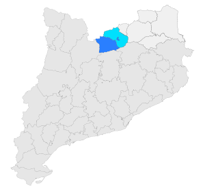 The modern natural comarca of Cerdanya in Catalonia and Pyrénées-Orientales.
Cerdanya proper was split between Spain and France by the Treaty of the Pyrenees of 1659, with the north of Cerdanya becoming French, while the south of Cerdanya remained Spanish. The counties of Rosselló, Capcir and Conflent also became French at that time.
Today, the Spanish side of Cerdanya is a Catalan comarca known as Baixa Cerdanya (i.e. "Lower Cerdanya"), and whose capital is Puigcerdà. Puigcerdà was already the capital of Cerdanya before the division of 1659, having replaced Hix in 1178 as capital of Cerdanya. Hix, the place where the counts of Cerdanya resided, is now a village inside the commune of Bourg-Madame on the French side of the border. Hix had itself replaced Llívia, which was the ancient capital of Cerdanya in Antiquity. At the Treaty of the Pyrenees it was decided that Llívia would remain Spanish (allegedly because the treaty stipulated that only villages were to be ceded to France, and Llívia was considered a city and not a village, due to its status as the ancient capital of Cerdanya), so Llívia is now an exclave of Spain inside French territory.
The French side of Cerdanya is part of the département of Pyrénées-Orientales and has no particular status. People in France refer to it as Cerdagne française (that is, "French Cerdanya"), or just Cerdagne, while people on the Spanish side refer to it as Alta Cerdanya ("Upper Cerdanya"). Its main towns are Bourg-Madame and the ski resort of Font-Romeu.
Tourism
Like neighboring areas of the Pyrenees, Cerdanya relies upon tourism to provide a strong support for the economy. Spa, skiing, and hiking are long-established activities. In addition the Yellow train is a major tourist attraction.
Municipalities
Spanish side
Known as Baixa Cerdanya.
- Alp
- Bellver de Cerdanya
- Bolvir
- Das
- Fontanals de Cerdanya
- Ger
- Guils de Cerdanyà
- Isòvol
- Lles de Cerdanya
- Llívia
- Meranges
- Montellà i Martinet
- Prats i Sansor
- Prullans
- Puigcerdà
- Riu de Pendís
- Urús
French side
Known as Cerdagne française (Catalan: Alta Cerdanya).
- Angoustrine-Villeneuve-des-Escaldes (Catalan: Angostrina)
- Bolquère (Catalan: Bolquera)
- Bourg-Madame (Catalan: La Guingueta d’Ix)
- Dorres
- Égat (Catalan Èguet)
- Enveitg (Catalan Enveig)
- Err (Catalan Er)
- Estavar
- Eyne (Catalan Eina)
- Font-Romeu-Odeillo-Via (Catalan Font-Romeu or Odelló i Vià)
- La Cabanasse (Catalan La Cabanassa)
- Latour-de-Carol (Catalan La Tor de Querol)
- Llo
- Mont-Louis (Catalan Montlluís)
- Nahuja (Catalan Naüja)
- Osséja (Catalan Osseja)
- Palau-de-Cerdagne (Catalan Palau de Cerdanya)
- Planès (Catalan Planès)
- Porta
- Porté-Puymorens (Catalan Portè)
- Saillagouse (Catalan Sallagosa)
- Saint-Pierre-dels-Forcats (Catalan Sant Pere dels Forcats)
- Sainte-Léocadie (Catalan Santa Llocaia)
- Targassonne (Catalan Targasona)
- Ur
- Valcebollère (Catalan: Vallsabollera)
External links
- La Cerdanya from Catalan Encyclopaedia
- County of Cerdanya from Catalan Encyclopaedia
- Counts of Cerdagne: genealogical tree
- Turisme Cerdanya Portal Cerdanya
Albères • Aspres • Capcir • Cerdagne • Conflent • Corbières catalanes • Fenouillèdes • Ribéral • Roussillon • Salanque • Vallespir • Côte Vermeille
 Categories:
- Geography of Catalonia
- Pyrenees
- Linguistic rights

Wikimedia Foundation. 2010.