- U.S. Route 9 in Delaware
-
This article is about the section of U.S. Route 9 in Delaware. For the entire length of the highway, see U.S. Route 9.
U.S. Route 9
Route information Maintained by DelDOT and DRBA Length: 30.92 mi[1] (49.76 km) Existed: 1970s – present Major junctions South end:  US 13 in Laurel


 US 9 Truck / US 113 in Georgetown

 DE 18 / DE 404 in Georgetown
US 9 Truck near Georgetown


 US 9 Bus. / DE 1 in Five Points
US 9 Bus. in LewesNorth end: Cape May-Lewes Ferry to US 9 in LewesHighway system United States Numbered Highways
List • Bannered • Divided • Replaced←  DE 8
DE 8DE 9  →
→←  DE 26
DE 26
DE 30  →
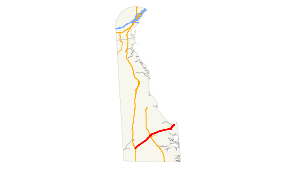
→In Delaware, U.S. Route 9 runs an east–west path through the heart of Sussex County. Even though U.S. Route 9 is signed north–south for the rest of its route, the segment in Delaware is considered east–west. The highway runs from its southern terminus at U.S. Route 13 in Laurel to the Cape May-Lewes Ferry in Lewes, which connects the Delaware segment of U.S. Route 9 to its counterpart in New Jersey. What is now US 9 in Delaware was originally designated by 1936 as Delaware Route 28 between Laurel and Georgetown and a part of DE 18 between Georgetown and Lewes. US 9 was extended to Delaware from New Jersey by way of the Cape May-Lewes Ferry by 1976, replacing all of DE 28 and the portion of DE 18 between Georgetown and Five Points, with the route aligned to bypass Lewes. DE 404 was designated along the portion of US 9 between Georgetown and Five Points by 1987.
Contents
Route description
U.S. Route 9 starts out at an intersection with U.S. Route 13 in the northern part of Laurel, heading to the northeast on the County Seat Highway. It passes through rural areas and intersects Delaware Route 20 in Hardscrabble. It the continues to Georgetown, where just west of the central business district of Georgetown, U.S. Route 9 intersects U.S. Route 113 and becomes Market Street. At this point, a truck bypass of U.S. Route 9 in Georgetown, U.S. Route 9 Truck, loops to the south of Georgetown, returning to U.S. Route 9 east of Georgetown. At the downtown circle in Georgetown, U.S. Route 9 meets Delaware Route 18 and Delaware Route 404, which is part of a major route between the Baltimore-Washington Metropolitan Area and the Delaware beaches by way of the Chesapeake Bay Bridge. Delaware Route 404 overlaps U.S. Route 9 for the purpose of providing a one-number route for beach traffic from the Baltimore-Washington Area.[1][2]

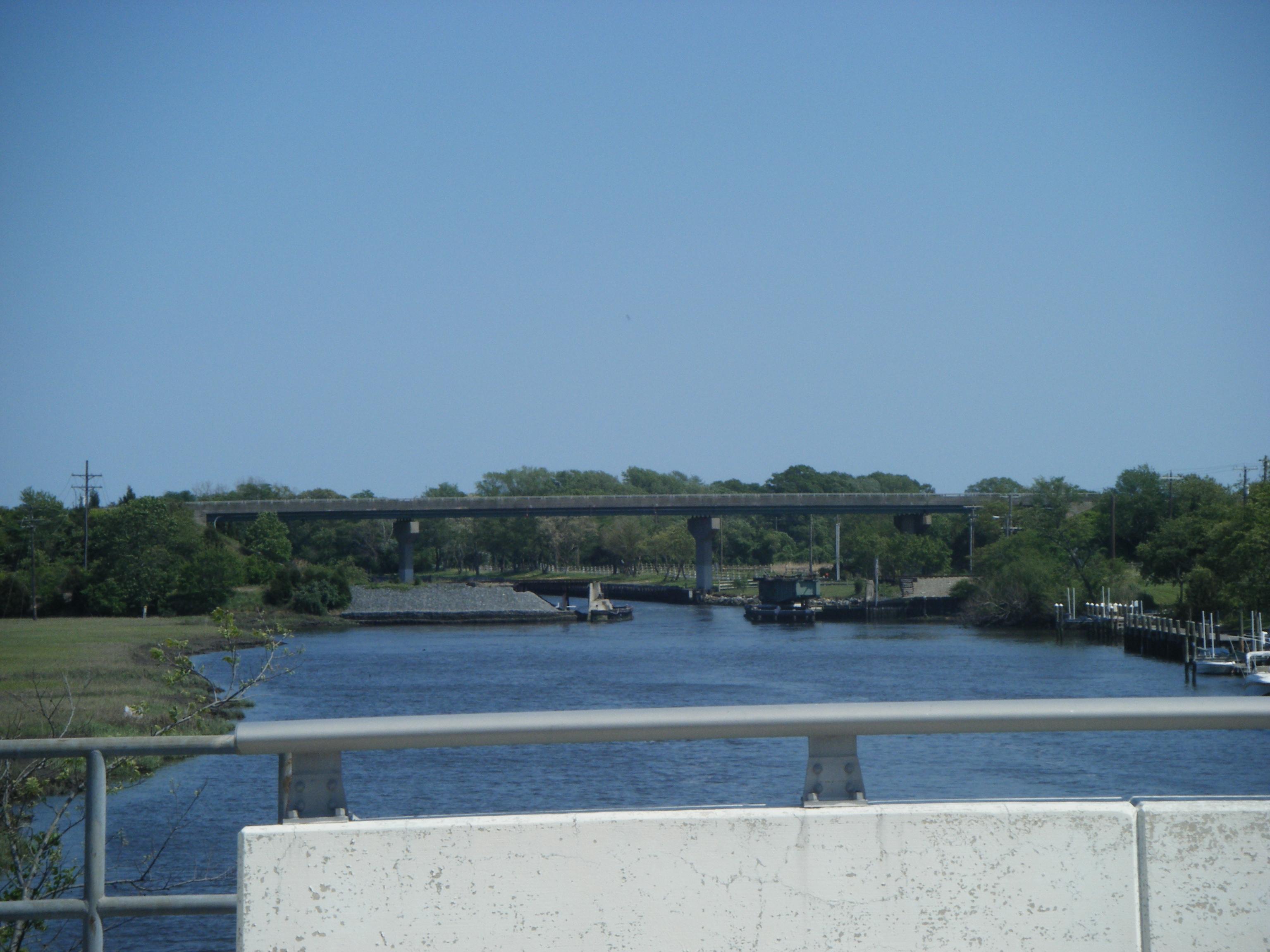
The concurrent U.S. Route 9 and Delaware Route 404 then continue east on the Lewes Georgetown Highway through rural eastern Sussex County, intersecting Delaware Route 30 in Gravel Hill and Delaware Route 5 in Harbeson. The continue east to the Five Points intersection in Nassau. It intersects Delaware Route 23 and Delaware Route 1D and then intersects Delaware Route 1, where Delaware Route 404 ends and U.S. Route 9 Business heads east into Lewes. U.S. Route 9 itself turns south for a concurrency with Delaware Route 1. In Carpenters Corner, it turns east onto Dartmouth Drive briefly before making a left and bypassing the heart of Lewes to the south on Kings Highway and the Theodore C. Freeman Highway. The route crosses the Lewes and Rehoboth Canal on a high-level bridge. At the east end of the Theodore C. Freeman Highway on the Delaware Bay, U.S. Route 9 re-meets U.S. Route 9 Business. U.S. Route 9 then continues a brief distance on Henlopen Drive before reaching the Cape May-Lewes Ferry terminal, where the ferry carries the route to Cape May, New Jersey.[1][2]
History
What is currently US 9 in Delaware existed as a state highway between Whaleys Corners and Georgetown by 1920, with the remainder as an unimproved county road. At the time, the road was a state aid highway between Laurel and Whaleys Corners and under contract as a state aid highway between Georgetown and Harbeson.[3] By 1924, the state highway along the present alignment of US 9 was completed, running from Laurel through Georgetown to Lewes.[4] By 1925, what is now US 9 along the DE 1 concurrency was built as a state highway.[5] The Kings Highway portion of the current route was paved by 1931.[6] When Delaware assigned numbers to its state highways by 1936, DE 28 was designated to run from US 13 in Laurel to DE 18 in Georgetown while the road between Georgetown and Lewes became a part of DE 18.[7] By 1954, US 13 was moved to a new alignment to the east of Laurel, and the western terminus of DE 28 was truncated to the new location of US 13.[8] The Cape May-Lewes Ferry was started in 1964; at this time, the ferry did not carry a route number.[9]
By 1976, US 9 was extended across the ferry from New Jersey to Delaware, replacing DE 28 between Laurel and Georgetown and DE 18 between Georgetown and Five Points. Between Five Points and the terminal of the Cape May-Lewes Ferry, US 9 followed DE 14 (now DE 1), Kings Highway, and Theodore C. Freeman Highway before coming to Cape Henlopen Drive. At the same time, US 9 Business was designated onto the former alignment of DE 18 between Five Points and Lewes as well as a portion of Cape Henlopen Drive connecting to US 9.[10] US 9 Truck was created as a truck bypass of the portion of US 9 through Georgetown by 1984.[11] DE 404 was extended to follow US 9 between Georgetown and Five Points by 1987.[12]
Junction list
The entire route is in Sussex County.
Location Milepost[1] Intersecting road Notes Laurel 0.00 US 13 (Sussex Highway)Hardscrabble 5.54  DE 20 (Concord Road/Hardscrabble Road)
Georgetown 12.05
US 9 Truck east / US 113 (DuPont Boulevard)12.79 DE 18 west / DE 404 west (North Bedford Street)Traffic circle, west end of DE 404 overlap 14.00
US 9 Truck west (Park Avenue)Gravel Hill 15.70 DE 30 (Gravel Hill Road)Harbeson 18.85  DE 5 (Harbeson Road)
Nassau 22.50 
 DE 1D south (Plantation Road) / DE 23 south (Beaver Dam Road)
West end of DE 1D/DE 23 overlap 25.21
US 9 Bus. east (Savannah Road) / DE 1 north (Coastal Highway) – Milford, DoverEast end of DE 1D/DE 23/DE 404 overlap
West end of DE 1 overlapCarpenters Corner 26.33 DE 1 south (Coastal Highway)East end of DE 1 overlap Lewes 29.21
US 9 Bus. west (Cape Henlopen Drive) – Lewes Beach, Downtown Lewes30.92 Cape May-Lewes Ferry - Cape May, NJ, Garden State Parkway 1.000 mi = 1.609 km; 1.000 km = 0.621 mi See also
 U.S. Roads portal
 Delaware portal
References
- ^ a b c d "Traffic Count and Mileage Report: Interstate, Delaware, and US Routes" (PDF). Delaware Department of Transportation. 2008. http://deldot.gov/information/pubs_forms/manuals/traffic_counts/2008/pdf/TRAFFICBOOK_RTES.pdf. Retrieved 2010-04-15.
- ^ a b Google, Inc. Google Maps – overview of U.S. Route 9 in Delaware (Map). Cartography by Google, Inc. http://maps.google.com/maps?saddr=US+9+and+US+13&daddr=38.75566,-75.14828+to:38.775004,-75.130599+to:Cape+May-Lewes+Ferry+Entrance&hl=en&sll=38.763052,-75.148029&sspn=0.064918,0.169086&geocode=FaGITAIdBAF_-yk9N4-Kjfq4iTGk100-vwt-EQ%3BFUxdTwIdCFSF-ykNjS-yZre4iTH0XyL5uVRYJA%3BFdyoTwIdGZmF-ynJc4AWNbe4iTEhejUgH15o9w%3BFWfFTwIdG8OF-w&vpsrc=0&mra=ls&via=1,2&t=h&z=11. Retrieved November 22, 2011.
- ^ Delaware Department of Transportation (PDF). Delaware Official Highway Map (Map) (1920 ed.). http://www.deldot.gov/archaeology/historic_pres/historic_highway_maps/pdf/cd_002.pdf. Retrieved 2010-04-15.
- ^ Delaware Department of Transportation (PDF). Delaware Official Highway Map (Map) (1924 ed.). http://www.deldot.gov/archaeology/historic_pres/historic_highway_maps/pdf/cd_003.pdf. Retrieved 2010-08-01.
- ^ Delaware Department of Transportation (PDF). Delaware Official Highway Map (Map) (1925 ed.). http://www.deldot.gov/archaeology/historic_pres/historic_highway_maps/pdf/cd_004.pdf. Retrieved 2010-08-19.
- ^ Delaware Department of Transportation (PDF). Delaware Official Highway Map (Map) (1931 ed.). http://www.deldot.gov/archaeology/historic_pres/historic_highway_maps/pdf/cd_005.pdf. Retrieved 2010-08-19.
- ^ Delaware Department of Transportation (PDF). Delaware Official Highway Map (Map) (1936/37 ed.). http://www.deldot.gov/archaeology/historic_pres/historic_highway_maps/pdf/cd_008.pdf. Retrieved 2010-04-15.
- ^ Delaware Department of Transportation (PDF). Delaware Official Highway Map (Map) (1954/55 ed.). http://www.deldot.gov/archaeology/historic_pres/historic_highway_maps/pdf/cd_028.pdf. Retrieved February 6, 2011.
- ^ Delaware Department of Transportation (PDF). Delaware Official Highway Map (Map) (1964 ed.). http://www.deldot.gov/archaeology/historic_pres/historic_highway_maps/pdf/cd_036.pdf. Retrieved April 15, 2010.
- ^ Delaware Department of Transportation (PDF). Delaware Official Highway Map (Map) (1976 ed.). http://www.deldot.gov/archaeology/historic_pres/historic_highway_maps/pdf/cd_054.pdf. Retrieved 2010-04-15.
- ^ Delaware Department of Transportation (PDF). Delaware Official Highway Map (Map) (1984 ed.). http://www.deldot.gov/archaeology/historic_pres/historic_highway_maps/pdf/cd_062.pdf. Retrieved February 5, 2011.
- ^ Delaware Department of Transportation (PDF). Delaware Official Highway Map (Map) (1987 ed.). http://www.deldot.gov/archaeology/historic_pres/historic_highway_maps/pdf/cd_064.pdf. Retrieved 2010-04-29.
U.S. Route 9Previous state:
TerminusDelaware Next state:
New JerseyCategories:- U.S. Highways in Delaware
- U.S. Route 9
- Transportation in Sussex County, Delaware


Wikimedia Foundation. 2010.