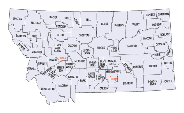
- Montana census statistical areas
-
The United States Census Bureau has defined three Metropolitan Statistical Areas (MSAs)[1] and five Micropolitan Statistical Areas (USAs)[2] in the State of Montana. The following table describes these areas with the following information:
- The name of the Core Based Statistical Area (CBSA).[3]
- The population of the CBSA as of 2006-07-01, as estimated by the United States Census Bureau.[4]
- The name of the county.
- The population of the county as of 2006-07-01, as estimated by the United States Census Bureau.[5]
See also
United States census statistical areas by state, district, or territoryMTASMPGUVI- State of Montana
- Demographics of Montana
- Geography of Montana
- United States
References
- ^ The United States Census Bureau defines a Metropolitan Statistical Area (MSA) as a Core Based Statistical Area having at least one urbanized area of 50,000 or more population, plus adjacent territory that has a high degree of social and economic integration with the core as measured by commuting ties.
- ^ The United States Census Bureau defines a Micropolitan Statistical Area (USA) as a Core Based Statistical Area having at least one urban cluster of at least 10,000 but less than 50,000 population, plus adjacent territory that has a high degree of social and economic integration with the core as measured by commuting ties.
- ^ The United States Census Bureau defines a Core Based Statistical Area (CBSA) as one or more adjacent counties or county equivalents that have at least one urban cluster of at least 10,000 population, plus adjacent territory that has a high degree of social and economic integration with the core as measured by commuting ties. The Census Bureau has defined two types of CBSAs: (1) a Metropolitan Statistical Area (MSA), which has an urban core population of 50,000 or more, or (2) a Micropolitan Statistical Area (USA), which has an urban core population of 10,000 or more but less than 50,000.
- ^ "Annual Estimates of the Population of Metropolitan and Micropolitan Statistical Areas: April 1, 2000 to July 1, 2006 (CBSA-EST2006-01)" (CSV). 2006 Population Estimates. United States Census Bureau, Population Division. 2007-04-05. http://www.census.gov/population/www/estimates/metro_general/2006/CBSA-EST2006-01.csv. Retrieved 2007-04-06.
- ^ "Annual County Population Estimates and Estimated Components of Change: April 1, 2000 to July 1, 2006 (CO-EST2006-alldata)" (CSV). 2006 Population Estimates. United States Census Bureau, Population Division. 2007-03-22. http://www.census.gov/popest/counties/files/CO-EST2006-ALLDATA.csv. Retrieved 2007-04-06.
External links
 State of Montana
Helena (capital) Topics History · Governors · People · Geography · State Government · Delegations · Visitor Attractions
Society Crime · Demographics · Economy · Education · Politics
Regions The Flathead · Glacier National Park · Regional designations of Montana · Western Montana · Yellowstone
Largest cities Counties Beaverhead · Big Horn · Blaine · Broadwater · Carbon · Carter · Cascade · Chouteau · Custer · Daniels · Dawson · Deer Lodge · Fallon · Fergus · Flathead · Gallatin · Garfield · Glacier · Golden Valley · Granite · Hill · Jefferson · Judith Basin · Lake · Lewis and Clark · Liberty · Lincoln · Madison · McCone · Meagher · Mineral · Missoula · Musselshell · Park · Petroleum · Phillips · Pondera · Powder River · Powell · Prairie · Ravalli · Richland · Roosevelt · Rosebud · Sanders · Sheridan · Silver Bow · Stillwater · Sweet Grass · Teton · Toole · Treasure · Valley · Wheatland · Wibaux · Yellowstone
Categories:- Metropolitan areas of Montana
- Micropolitan areas of Montana
- Census statistical areas
- Montana-related lists
Wikimedia Foundation. 2010.


