- Kyōtango, Kyoto
-
Kyōtango
京丹後市— City — 
FlagLocation of Kyōtango in Kyoto Prefecture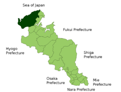

 Kyōtango
Coordinates: 35°37′N 135°8′E / 35.617°N 135.133°ECoordinates: 35°37′N 135°8′E / 35.617°N 135.133°E Country Japan Region Kansai Prefecture Kyoto Prefecture Area – Total 501.84 km2 (193.8 sq mi) Population (April 30, 2008) – Total 62,782 – Density 122/km2 (316/sq mi) Time zone Japan Standard Time (UTC+9) Phone number 0772-69-0001 Address 889 Sugitani, Mineyama-chō, Kyōtango-shi, Kyoto-fu
627-8567Website City of Kyōtango Kyōtango (京丹後市 Kyōtango-shi, population 67,000) is a city in Kyoto Prefecture, Japan. It was formed on April 1, 2004 by the merger of the towns of Mineyama and Omiya, both from Naka District, the towns of Amino, Tango and Yasaka, all from Takeno District, and the town of Kumihama, from Kumano District. Naka, Takeno and Kumano Districts were dissolved as a result of the merger.
Located on the coast of the Sea of Japan on the western side of the Tango Peninsula in the northwestern corner of the prefecture, the new city has its city hall in the former town hall of Mineyama.
Mineyama, now part of Kyōtango, has a close connection with the Hagoromo legend.
The Kumihama area is well known for its many hot springs, while Amino is one of the major producers of the Tango Chirimen.
Neighbouring municipalities
External links
 Media related to Kyōtango, Kyoto at Wikimedia Commons
- Kyōtango Official Website (Japanese)
 Kyoto Prefecture
Kyoto (capital city) 
Other cities Funai District Kuse District Otokuni District Sōraku District Tsuzuki District Yosa District Categories:- Cities in Kyoto Prefecture
- Kyoto geography stubs


Wikimedia Foundation. 2010.