- Mallabula, New South Wales
-
Mallabula
New South Wales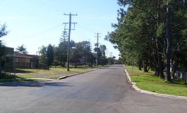
Main road of MallabulaPopulation: 1,097[1] • Density: 406/km² (1,051.5/sq mi) Note1 Postcode: 2319 Coordinates: 32°44.1′S 152°0.6′E / 32.735°S 152.01°ECoordinates: 32°44.1′S 152°0.6′E / 32.735°S 152.01°E Elevation: 3 m (10 ft) Note2 Area: 2.7 km² (1.0 sq mi) Note3 Time zone: • Summer (DST)
AEST (UTC+10) AEDT (UTC+11)
Location: - 192 km (119 mi) NNE of Sydney
- 45 km (28 mi) NNE of Newcastle
- 30 km (19 mi) ENE of Raymond Terrace
LGA: Port Stephens Council Region: Hunter County: Gloucester[2] Parish: Sutton[2] State District: Port Stephens Federal Division: Paterson Mean max temp Mean min temp Annual rainfall 27.3 °C
81 °F8.4 °C
47 °F1,348.9 mm
53.1 inSuburbs around Mallabula: Port Stephens Port Stephens Port Stephens Tanilba Bay Mallabula Lemon Tree Passage Tanilba Bay Tilligerry Creek Tilligerry Creek Mallabula is a primarily residential suburb of the Port Stephens Local Government Area in the Hunter Region of New South Wales, Australia. It is located on the Tilligerry Peninsula between Lemon Tree Passage and Tanilba Bay.[3][4]
Contents
Geography
Mallabula is a low-lying suburb, almost at sea level.Note3 It is bisected by Lemon Tree Passage Road, which stretches for the full length of the peninsula, from Salt Ash in the south-west, to Lemon Tree Passage. In the northern part of the suburb is a small subdivision covering 0.6 square kilometres (0.2 sq mi) on the banks of Tanilba Bay.
 Tanilba Bay from Mallabula showing the beaches typical of both suburbs
The beach consists mainly of sand flats that are exposed at low tide and almost completely covered at high tide preventing the beach from being useful as either a swimming or surfing beach. Near Rookes Point, at the mouth of Tanilba Bay, the land rises to a height of 9.1 metres (30 ft) AMSL. At the eastern extremity of this area the land reaches a peak of 18.3 m (60 ft) in a heavily forested area. However, between these two points and throughout the remainder of the suburb the land is generally no more than 3 m (10 ft) AMSL and is predominantly sandy.
The land south of Lemon Tree Passage Road is generally uninhabited, occupied only by a handful of homes in a single cul-de-sac and a sewage treatment plant.[4]
Demographics
At the 2006 Census Mallabula had a population of 1,097.[1] Almost all of the population resides in a small, residential subdivision occupying only 22.8% of the entire suburb. The population density in this area is 1,828 /km2 (4,730 /sq mi). The remaining population resides in four homes in a single cul-de-sac south of Tanilba Bay and is accounted for in the ABS population data for that suburb.[5]
Notes
- ^ This is the average density of the whole suburb. However, approximately 2.1 km2 (0.8 sq mi) (77.8%) of the suburb is uninhabited or consists of non-residential zones at the edge of the suburb and the average population density in the inhabited portion of the suburb is much higher.
- ^ Elevation data as shown on 1:100000 map 9232 NEWCASTLE and 1:25000 map 93324S PORT STEPHENS.
- ^ Area calculation is based on 1:100000 map 9232 NEWCASTLE. The area presented is that of the whole suburb. The residential portion of the suburb is only 0.6 km2 (0.2 sq mi) or 22.2% of the total area.
References
- ^ a b Australian Bureau of Statistics (25 October 2007). "Mallabula (State Suburb)". 2006 Census QuickStats. http://www.censusdata.abs.gov.au/ABSNavigation/prenav/LocationSearch?collection=Census&period=2006&areacode=SSC17945&producttype=QuickStats&breadcrumb=PL&action=401. Retrieved 28 May 2008. Map
- ^ a b "Geographical Names Register Extract: Mallabula". Geographical Names Register (GNR) of NSW. Geographical Names Board of New South Wales. http://www.gnb.nsw.gov.au/name_search/extract?id=anYbjzqbMn. Retrieved 28 May 2008.
- ^ "Suburb Search - Local Council Boundaries - Hunter (HT)". New South Wales Department of Local Government. http://www.dlg.nsw.gov.au/dlg/dlghome/dlg_Regions.asp?region=HT®iontype=1. Retrieved 28 May 2008.
- ^ a b "Mallabula". Land and Property Management Authority - Spatial Information eXchange. New South Wales Land and Property Management Authority. http://imagery.maps.nsw.gov.au/?role=mysuburb&search=suburb&suburb=Mallabula. Retrieved 28 May 2008.
- ^ "Tanilba Bay CCD map". 2006 Census QuickStats. Australian Bureau of Statistics. 25 October 2007. http://www.censusdata.abs.gov.au/ABSNavigation/ImageServer?id=map,Census,2006,SSC18961. Retrieved 28 May 2008.
- "Nelson Bay (Nelson Head)". Climate statistics for Australian locations. Bureau of Meteorology. http://www.bom.gov.au/climate/averages/tables/cw_061054.shtml. Retrieved 2 June 2008.
Towns, suburbs and localities of Port Stephens Council | Hunter Region | New South Wales Towns, suburbs
& localitiesAnna Bay • Balickera • Boat Harbour • Bobs Farm • Brandy Hill • Butterwick • Campvale • Corlette • Duns Creek • Eagleton • East Seaham • Fern Bay • Ferodale • Fingal Bay • Fishermans Bay • Fullerton Cove • Glen Oak • Heatherbrae • Hinton • Karuah • Lemon Tree Passage • Mallabula • Medowie • Nelson Bay • Nelsons Plains • One Mile • Osterley • Oyster Cove • Raymond Terrace • Salamander Bay • Salt Ash • Seaham • Shoal Bay • Soldiers Point • Swan Bay • Tanilba Bay • Taylors Beach • Tomago • Twelve Mile Creek • Wallalong • Williamtown • Woodville
Other places &
points of interestEdgeworth David quarry • Hunter River • Karuah River • Newcastle Airport • Paterson River • Port Stephens • RAAF Base Williamtown • Stockton Beach • MV Sygna shipwreck • Tomaree National Park • Williams River
Categories:- Suburbs of Port Stephens Council
- Beaches of New South Wales


Wikimedia Foundation. 2010.