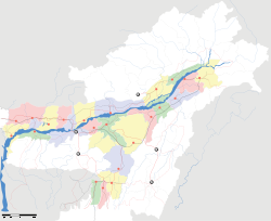
Mahur, Assam

Mahur, Assam
Mahur
—  city  —
Mahur
Location of Mahur
in Assam and India
Coordinates 25°10′N 93°07′E / 25.17°N 93.12°E / 25.17; 93.12Coordinates: 25°10′N 93°07′E / 25.17°N 93.12°E / 25.17; 93.12
Country India
State Assam
District(s) Dima Hasao
Population 5,485 (2001)
Time zone IST (UTC+05:30)
Area

Elevation


727 metres (2,385 ft)

Please see Mahur for disambiguation.

Mahur is a town and a town area committee in Dima Hasao district in the Indian state of Assam.

Geography

Mahur is located at 25°10′N 93°07′E / 25.17°N 93.12°E / 25.17; 93.12.[1] It has an average elevation of 727 metres (2385 feet).

Demographics

As of 2001 India census,[2] Mahur had a population of 5485. Males constitute 55% of the population and females 45%. Mahur has an average literacy rate of 76%, higher than the national average of 59.5%: male literacy is 80%, and female literacy is 71%. In Mahur, 13% of the population is under 6 years of age.

References

  1. ^ Falling Rain Genomics, Inc - Mahur
  2. ^ "Census of India 2001: Data from the 2001 Census, including cities, villages and towns (Provisional)". Census Commission of India. Archived from the original on 2004-06-16. http://web.archive.org/web/20040616075334/http://www.censusindia.net/results/town.php?stad=A&state5=999. Retrieved 2008-11-01. 

Wikimedia Foundation. 2010.

Игры ⚽ Нужна курсовая?

Look at other dictionaries:

  • Mahur — may refer to: Geography: Mahur, Maharashtra, India Mahur, Assam, India Music: Dastgāh e Māhur is a mode (dastgah, maqam, mayeh) in Persian traditional music, identical to the Western major scale Mahur is a makam in the music of Turkey …   Wikipedia

  • Mahur — Localidad de la India …   Wikipedia Español

  • Dima Hasao — Distrikt Dima Hasao Bundesstaat: Assam Verwaltungssitz: Haflong Fl …   Deutsch Wikipedia

  • India — /in dee euh/, n. 1. Hindi, Bharat. a republic in S Asia: a union comprising 25 states and 7 union territories; formerly a British colony; gained independence Aug. 15, 1947; became a republic within the Commonwealth of Nations Jan. 26, 1950.… …   Universalium

  • Maithili language — Maithili मैथिली, মৈথিলী ,maithilī Spoken in India, Nepal Region Bihar, Jharkhand, parts of West Bengal in India, Terai Region in Nepal Nativ …   Wikipedia

  • Maibong —   city   …   Wikipedia

  • List of Hindu temples — Hindu temple is called Mandir or Kovil or Devasthanam or Dega (Nepal Bhasa) or Ambalam (Malayalam) or other words in different Indian languages. It is usually dedicated to a primary deity, called the presiding deity, and other deities associated… …   Wikipedia

  • Mehndi — For other uses, see Mehndi (disambiguation). Mehndi applied on a palm …   Wikipedia

  • Buldhana district — This article is about the district. For its eponymous headquarters, see Buldhana. 19°31′N 75°34′E / 19.51°N 75.57°E / 19.51; 75.57 …   Wikipedia

Share the article and excerpts

Direct link
Do a right-click on the link above
and select “Copy Link”