- North Frodingham
-
Coordinates: 53°57′46″N 0°19′22″W / 53.962785°N 0.322752°W
North Frodingham 
 North Frodingham
North Frodingham shown within the East Riding of YorkshirePopulation 712 (2001 census)[1] OS grid reference TA101531 Parish North Frodingham Unitary authority East Riding of Yorkshire Ceremonial county East Riding of Yorkshire Region Yorkshire and the Humber Country England Sovereign state United Kingdom Post town DRIFFIELD Postcode district YO25 Dialling code 01262 Police Humberside Fire Humberside Ambulance Yorkshire EU Parliament Yorkshire and the Humber UK Parliament East Yorkshire List of places: UK • England • Yorkshire North Frodingham is a village and civil parish in the East Riding of Yorkshire, England. It is situated approximately 5.5 miles (8.9 km) south east of the town of Driffield and lies on the B1249 road.
 North Frodingham
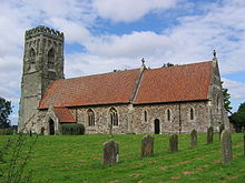 St Elgin's church, North Frodingham
The civil parish is formed by the village of North Frodingham and the hamlets of Church End and Emmotland. According to the 2001 UK census, North Frodingham parish had a population of 712.[1] The church of St Elgin, North Frodingham was restored in stages between 1877-91 by Sir Tatton Sykes, 5th Baronet with the top part of the perpendicular tower being designed by Temple Moor. It is on the Sykes Churches Trail devised by the East Yorkshire Churches Group. In 1901, there was a proposal to construct a railway terminus as part of the North Holderness Light Railway, but despite appearing on the North Eastern Railway's tile maps at various stations (including Beverley), the line was never constructed.[2] The Old Howe and North Frodingham beck join to the west of the village. The landing was used until the 1950s for unloading coal transported from Kingston upon Hull.
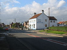
North Frodingham has two pubs, The Star Inn and the Blue Post Inn. The village has a small park overlooking the social centre. There are lots of fields and farms surrounding the village.
There is a village store (The Post Office) and a carpet shop. There are not many types of transport, with only a bus stop or by car.
References
- ^ a b "2001 Census: Key Statistics: Parish Headcounts: Area: North Frodingham CP (Parish)". Neighbourhood Statistics. Office for National Statistics. http://neighbourhood.statistics.gov.uk/dissemination/LeadTableView.do?a=3&b=791012&c=North+Frodingham&d=16&e=15&g=390787&i=1001x1003x1004&m=0&r=1&s=1211196933330&enc=1&dsFamilyId=779. Retrieved 19 May 2008.
- ^ "A Guide to the Driffield Navigation (1983) - A Brief History". Driffield Navigation Guide. 16 February 2006. http://www.driffieldnavigation.co.uk/a_brief_history. Retrieved 8 February 2008.
- Gazetteer — A–Z of Towns Villages and Hamlets. East Riding of Yorkshire Council. 2006. p. 8.
Categories:- Villages in the East Riding of Yorkshire
- Civil parishes in the East Riding of Yorkshire
- East Riding of Yorkshire geography stubs


Wikimedia Foundation. 2010.