- Interstate 95 in Baltimore, Maryland
Infobox road
state=MD
type=I
route=95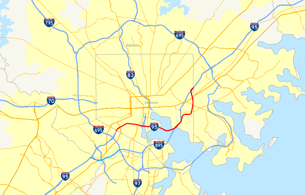
maint=MdTA
established=1969 (completed 1985)
length_mi=11.29
length_ref=Maryland State Highway Administration , [http://www.sha.state.md.us/KeepingCurrent/performTrafficStudies/dataAndStats/hwyLocationRef/oppe/hlr.asp Highway Location Reference] , 2005]
length_round=2
direction_a=South
direction_b=North
starting_terminus=Jct|state=MD|I|95 near Halethorpe
junction=Jct|state=MD|MD|295 near Westport
Jct|state=MD|I|395 neardowntown Baltimore
Jct|state=MD|I|895 near Cedonia
ending_terminus=Jct|state=MD|I|95 near RosedaleInBaltimore, Maryland ,United States , Interstate 95 runs through the southwestern quadrant of the city before turning east, skirting the edge of the central business district and crossing thePatapsco River via theFort McHenry Tunnel . Beyond the tunnel, it turns north and exits the city just beyond the northern terminus of Interstate 895.The route is a critical component of the Baltimore freeway network, serving thousands of commuters and through vehicles every day. Its defining features include the interchange with Interstate 395, the high-mast light towers that are prominent throughout the Maryland portion of the Interstate (especially on its southbound trek towards
Washington, D.C. ), and theFort McHenry Tunnel .Route description
South of Baltimore, Interstate 95 is maintained by the
Maryland State Highway Administration ; north of the southern Baltimore city line, I-95 changes jurisdiction to theMaryland Transportation Authority . Continuing on its northeasterly track, the route intersects US 1 Alt. just beyond the city line. I-95's interchange with US 1 Alt. incorporates stubs and unused embankments that would have been used for the planned eastern terminus of I-70 within Baltimore (later planned as the southern terminus of I-595, before that designation was moved to US 50 east of Washington). Continuing past this unbuilt interchange, I-95 intersects Washington Blvd., a local city street, before encountering the main access route into the central business district, Interstate 395. I-95 also interchanges with the northern terminus of theBaltimore-Washington Parkway within the I-395 interchange, which is almost completely elevated over the Middle Branch of thePatapsco River . After interchanging with both routes, I-95 interchanges with MD 2 and Key Highway, the latter route offering access toFort McHenry and an escape route for hazardous material traffic.I-95 encounters the
Fort McHenry Tunnel south ofFort McHenry . The tunnel, containing eight lanes, curves underneath the Northwest Harbor and emerges in the Canton neighborhood of Baltimore, quickly encountering the toll plaza. After the toll plaza, I-95 encounters the Boston St.-O'Donnell St. interchange, which also incorporates stubs and other unused infrastructure planned to be used for the southern terminus ofInterstate 83 ; I-95 also passes over I-895 within the interchange area, with no access between the two routes, then runs into East Baltimore, providing local access to various city streets in lieu of I-895. It interchanges with the Moravia Road freeway spur next to the Baltimore city line (where ramp stubs were once planned for an unbuilt portion of the Windlass Freeway), then connects with US 40 before narrowing to six lanes and merging with I-895 just after exiting Baltimore.Unbuilt interchanges
I-95 is unique in having three unbuilt interchanges along its route within Baltimore, a sign of the many successful
freeway revolts that accompanied the construction of the 3-A System.The first is located near Exit 50 in Baltimore; it is the site of the planned eastern terminus of Interstate 70 within the city. The only remnants of the interchange that remain in situ today are the mainline bridges built to grade-separate I-95 and the exit ramps to and from I-70, several ramp stubs, and a few grassy abutments. An incomplete flyover bridge once existed as well, but was later demolished. While this interchange was left incomplete, the existing Exit 50, built with extensive collector-distributor lanes due to its proximity to the unbuilt interchange, stands as a more visible sign of what was planned. Today, Exit 50 connects Alt US 1 to I-95. [http://www.pennways.com/RTTF/Balt-3A-I95-I70-I170.jpgScale drawing of I-70, I-170, I-95, I-395 interchanges in Baltimore City] ]
The second is located near Exit 57, just to the north of the
Fort McHenry Tunnel , and is the site of the planned southern terminus ofInterstate 83 . Like I-70's terminus, the remnants here consist mainly of ramp stubs and unused bridges. This interchange, like Exit 50, also serves Boston St. and O'Donnell St.; unlike Exit 50, I-95 narrows to six lanes within the interchange, as most traffic was expected to diverge onto I-83 north and thus into the downtown area. The interchange would have been a 3-way freeway-to-freeway interchange, with a full complement of ramps provided for local access to and from Boston St. and O'Donnell St., to and from both Interstates. [http://www.roadstothefuture.com/I83-I95-Int.jpgScale diagram of I-83/I-95 interchange in Baltimore City] ] Of the two planned Interstate termini, I-83's terminus was the first to be abandoned, with the connecting highway segment being cancelled in September 1982; I-70's terminus, later redesignated as a new route, was cancelled in July 1983.Kozel, Scott. [http://groups.google.com/group/misc.transport.road/msg/361d3e9967f8745c?dmode=source "misc.transport.road": Baltimore Interstate Highway Cancellation Details] URL accessed 12:57, 4 February 2007.]The third is encountered at Exit 60 and is the site of the southwestern terminus of the
Windlass Freeway , a relief route for US 40 (part of the route was eventually built and is today part of I-695). The interchange that exists at this site is in partial use, serving the Moravia Road freeway spur; like the other two inner-city locations, ramp stubs mark the site of the ramps to and from the unbuilt freeway.History
Planning
Several proposals were made during the 1940s and 1950s for an East-West Expressway through Baltimore. After nine different proposals were floated, in 1960 the city's Department of Planning published a proposal of its own. The route in the proposal would have started out as Interstate 70N (as it was known then) and run due east, crossing the city to the north of the Inner Harbor on an elevated viaduct within the central business district. The route would have met two other freeways, the
Jones Falls Expressway and the Southwest Expressway at a four-way interchange in the southeast edge of the CBD; I-95 would have followed the Southwest Expressway, and met both I-70N and I-83 (on the Jones Falls Expressway) at this interchange. I-70N and I-83 would have terminated at the interchange, while I-95 would have turned east and followed the East-West Expressway out of the CBD, along the Boston St. corridor and out towards East Baltimore, junctioning the Harbor Tunnel Thruway near the site of today's Exit 62. The Southwest Expressway would have cut throughFederal Hill and crossed the Inner Harbor on a fixed bridge with 50 feet of vertical navigational clearance. All of these proposed routes would have required extensive right-of-way acquisition and clearance.Kozel, Scott. [http://www.roadstothefuture.com/Balt_Early_Expwy_Plan.html "Roads to the Future:" Baltimore Early Expressway Planning] URL accessed 17:55, 5 February 2007.]The above routings were eventually further refined and modified and eventually became part of the "Baltimore 10-D Interstate System", approved in 1962. In this plan, I-95 would run east-west to the north of
Fort McHenry , similarly to the above proposal, but would have run along the southern edge of the CBD, passing to the north ofFederal Hill and cutting through the historicFells Point neighborhood. After crossing the Inner Harbor on another low bridge, it would have followed the Boston St. corridor, crossing the Harbor Tunnel Thruway near to where it does today, then followed the existing I-95 alignment out of the city. The highway would have junctioned Interstate 70N a mile to the northwest of the Inner Harbor, near the eastern terminus of the now-defunct Interstate 170; it would have junctionedInterstate 83 in the northeastern corner of the central business district. This routing was little different to the routings proposed in 1960, and was also universally disliked.Kozel, Scott. [http://www.roadstothefuture.com/Balt_Early_Expwy_Plan.html "Roads to the Future:" Baltimore Early Expressway Planning] URL accessed 17:55, 5 February 2007.]By 1969, the Design Concept Team, a multi-discipline group assembled in 1966 by the city government to help design freeway routings that would not disrupt the city's fabric, the 10-D System had been replaced by the "Baltimore 3-A Interstate and Boulevard System". In the 3-A system, I-95 was shifted south onto the Locust Point peninsula, and eventually constructed there. I-70N would have run through
Leakin Park andGwynns Falls Park to terminate at I-95 near Alt US 1, while I-83 was shifted to a new alignment and planned to terminate at I-95 north of thePatapsco River . Interstate 395 was also brought into existence under this plan; it was planned as a freeway spur from I-95 to the south edge of the central business district, connecting to a new route named City Boulevard (now known asMartin Luther King Jr. Boulevard ). The 3-A System's result was that I-95 would act as a bypass of the central business district, with I-395 providing direct access.Kozel, Scott. [http://www.roadstothefuture.com/Balt_Early_Expwy_Plan.html "Roads to the Future:" Baltimore Early Expressway Planning] URL accessed 17:55, 5 February 2007.]Construction
The first portion of I-95 in Baltimore was the southern 0.6 miles of the
John F. Kennedy Memorial Highway , completed in 1963. By 1971, I-95 had entered Baltimore proper when it was completed between the Capital Beltway and theBaltimore Beltway ; beyond the southern I-695 interchange, the highway came to a dead halt at Alt US 1. By 1974, I-95 was under construction in East Baltimore between its current merge with I-895 south to a partial-cloverleaf interchange with MD 150 Eastern Avenue. By 1976, I-95 was under construction east of Alt US 1 and south of MD 150. By 1981, I-95 was completed as far as I-395, and by 1984, with the construction of theFort McHenry Tunnel quite advanced, the route was open as far as MD 2 west of the Patapsco, and Boston St.-O'Donnell St. east of the Patapsco. With the final opening of the tunnel on November 23, 1985, I-95 was finally completed within the city of Baltimore.Miscellanea
Tolling
Originally, the toll plaza at the north end of the
Fort McHenry Tunnel was to be removed after the city of Baltimore repaid its share of the construction costs of the tunnel. However, theMaryland Transportation Authority lobbied successfully to keep the toll plaza in place to prevent a traffic problem on I-95 within Baltimore.Changes in jurisdiction
Originally, there were several changes in jurisdiction over maintenance of Baltimore's segment of I-95. North of the Baltimore city line as far as Exit 55 (Key Highway), the route was maintained by the city of Baltimore. Between Exit 55 and Exit 57 (Boston Street/O'Donnell Street) the route, traversing the
Fort McHenry Tunnel , was maintained by theMaryland Transportation Authority . Between Exit 57 and the Baltimore city line the route was again maintained by the city of Baltimore.Now, between the southern Baltimore city line (near Exit 49, the southern I-695 interchange) and the northern Baltimore city line, the route is maintained entirely by the
Maryland Transportation Authority .Kozel, Scott. [http://groups.google.com/group/misc.transport.road/msg/d9338a3f3dc0abe7?dmode=source "misc.transport.road": Re: Road trip report: New York, NY to Baltimore, MD/Washington, DC and back] URL accessed 13:04, 4 February 2007.] Maryland state highway police force and the authority's own police force share police duties on this segment. Additionally, the city of Baltimore pays the MdTA to maintain I-95 within the city limits.Kozel, Scott. [http://groups.google.com/group/misc.transport.road/msg/d9338a3f3dc0abe7?dmode=source "misc.transport.road": Re: Road trip report: New York, NY to Baltimore, MD/Washington, DC and back] URL accessed 13:04, 4 February 2007.]Exit list
Exits are numbered from south to north, in accordance with
AASHTO guidelines. I-95 enters Baltimore at mile 49.31 and leaves at mile 60.60.-ee also
*
Fort McHenry Tunnel
*Harbor Tunnel Thruway
*Interstate 95 in Maryland
*Interstate 395 (Maryland)
*Martin Luther King Jr. Boulevard References
External links
* [http://www.mdroads.com/routes/is095.html I-95 @ MDRoads.com]
* [http://www.roadstothefuture.com/Balt_10D_System.html "Roads to the Future:" Baltimore 10-D Interstate System Map]
* [http://www.roadstothefuture.com/Balt_Harbor_Interstate_Map.html "Roads to the Future:" Baltimore Harbor Interstate Map]
* [http://www.roadstothefuture.com/Balt_Expwy_History_1970.html "Roads to the Future:" Baltimore History of Expressway Planning - 1970]
Wikimedia Foundation. 2010.