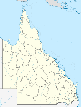
- Clarke Creek, Queensland
-
Clarke Creek
QueenslandPopulation: 193[1] Postcode: 4705 Coordinates: 22°38′08″S 149°15′25″E / 22.6355°S 149.2570°ECoordinates: 22°38′08″S 149°15′25″E / 22.6355°S 149.2570°E Location: - 790 km (491 mi) NW of Brisbane
- 175 km (109 mi) NW of Rockhampton
- 71 km (44 mi) W of Marlborough
LGA: Isaac Region State District: Mirani Federal Division: Capricornia Clarke Creek is a small community in Queensland, Australia. It is situated between Mackay and Rockhampton on the Old Bruce Highway. At the 2006 census, Clarke Creek and the surrounding area had a population of 193.[1]
Clarke Creek is known for its campdrafting and many come to see this event.
Most of the citizens in the area own or work on cattle stations for a living. There is a service station which many car and truck drivers rely on. At the service station there is also a caravan park used by many temporary road workers in the area.
There is a small school just off the May Downs Road, which is complete with a furnished tennis court, swimming pool, oval, playground facilities and amenities. Only around 20 children attend Clarke Creek State School each year, and once they have finished year 7 they leave to go to boarding school in a town such as Rockhampton, Mackay or Clermont.
References
- ^ a b Australian Bureau of Statistics (25 October 2007). "Clarke Creek (Broadsound Shire) (State Suburb)". 2006 Census QuickStats. http://www.censusdata.abs.gov.au/ABSNavigation/prenav/LocationSearch?collection=Census&period=2006&areacode=SSC35597&producttype=QuickStats&breadcrumb=PL&action=401. Retrieved 2008-01-27.
Categories:- Towns in Queensland
- Queensland geography stubs
Wikimedia Foundation. 2010.

