- Nabro Volcano
-
Nabro 
False-color topographical relief image of Nabro caldera (top; in Eritrea) next to the Mallahle volcanic caldera (in Ethiopia), then Mount Sarkali with the smaller Sork Ale caldera in the bottom right.Elevation 2,218 m (7,277 ft) [1] Location Southern Red Sea Region,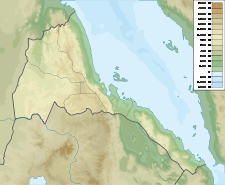
 Nabro
Nabro Eritrea
Coordinates 13°22′N 41°42′E / 13.37°N 41.70°ECoordinates: 13°22′N 41°42′E / 13.37°N 41.70°E[1] Geology Type Stratovolcano Last eruption 2011[2] The Nabro Volcano is a stratovolcano located in the Southern Red Sea Region of Eritrea. It is located in the Danakil Depression. Prior to its 2011 eruption it was widely believed to be extinct.
Contents
Geology
Part of the Afar Triangle, the Nabro Volcano is one of many volcanic caldera complexes in the northeasternmost part of the East African Rift valley region. The twin calderas likely formed during an eruption of about 20 to 100 cubic kilometres consisting of ignimbrite, although the date of their formation is unknown. The subaerial volume of volcanic material within the Nabro Volcanic Range mantle plume is likely on the order of 550 km3.[3]
2011 eruption
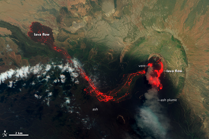
Main article: 2011 Nabro eruptionDespite having undergone no historically reported eruptions,[4] the Nabro Volcano erupted shortly after midnight local time on 13 June 2011, after a series of earthquakes ranging up to magnitude 5.7 in the Eritrea-Ethiopia border region.[4] The ash plume was observed on satellite drifting to the west-northwest along the border, spanning about 50 km wide and several hundred kilometres across in the hours immediately following the reported eruption, while reportedly reaching 15 km (9.3 mi) high.[4]
On 13 June US Secretary of State Hillary Clinton had to cut short a trip to Ethiopia due to the ash cloud, which was projected to enter a west-to-east jetstream and enter the atmosphere of countries such as Egypt, Yemen, Israel, Iraq, Jordan, Sudan, Somalia, Djibouti and Saudi Arabia.[5][6]
The ash cloud began disrupting air traffic as UAE-based Emirates flights were cancelled along with Saudi Arabian Airlines flights.[7][8] Luxor International Airport in Luxor, Egypt was placed on a state of emergency.[9]
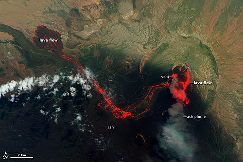 Lava Flows at Nabro Volcano, June 29, 2011
See also
References
- ^ a b "Nabro". Global Volcanism Program, Smithsonian Institution. http://www.volcano.si.edu/world/volcano.cfm?vnum=0201-101. Retrieved 2007-04-04.
- ^ Dunphy, Mark (June 13, 2011). "Ash Cloud Spreads From Erupting Nabro Volcano In Eritrea". Irish Weather Online. http://www.irishweatheronline.com/news/earthquakesvolcanos/ash-cloud-spreads-from-erupting-nabro-volcano-in-eritrea/19983.html. Retrieved June 13, 2011.
- ^ Wiart, Pierre; Clive Oppenheimer (25 May 2004). "Large magnitude silicic volcanism in north Afar: the Nabro Volcanic Range and Ma’alalta volcano". Bulletin of Volcanology 67 (2): 99–115. doi:10.1007/s00445-004-0362-x. http://www.springerlink.com/content/jaf8w52xm8g2r3u9/. Retrieved 13 June 2011.
- ^ a b c "Eruption at Nabro Volcano, Eritrea", NASA Earth Observatory. June 13, 2011. Accessed June 13, 2011
- ^ "Volcano Eruption in Eritrea cuts short Hillary Clinton visit", The Telegraph. June 13, 2011. Accessed June 13, 2011
- ^ "Ash Cloud Spreads From Erupting Nabro Volcano In Eritrea", Mark Dunphy. Irish Weather Online. June 13, 2011. Accessed June 13, 2011
- ^ "Emirates flights to Africa disrupted", Dubai Chronicle. June 14, 2011. Accessed June 14, 2011
- ^ "Saudi Airlines reschedules flights to Africa due to ash cloud", AME Info. June 15, 2011. Accessed June 15, 2011
- ^ "Luxor airport prepares for Eritrean volcanic ash cloud", Al-Masry Al-Youm. June 14, 2011. Accessed June 15, 2011
Categories:- Northern Red Sea Region
- Mountains of Eritrea
- Volcanoes of Eritrea
- Stratovolcanoes

Wikimedia Foundation. 2010.