- Southern Red Sea Region
-
Southern Red Sea Zone
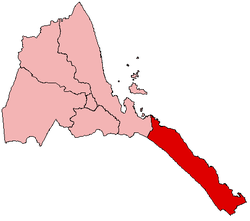
Zoba Debubawi Keyih Bahri— Zoba — Map of Eritrea with the Southern Red Sea Region highlighted Country Eritrea Capital Asseb Government – Administrator Tsegereda Woldegergish Area – Total 27,600 km2 (10,656.4 sq mi) Population – Total 203,618 – Density 7.4/km2 (19.1/sq mi) The Southern Red Sea Region of Eritrea is one of the six main regions of Eritrea. It lies along the southern half of the Red Sea, and contains the coastal city of Asseb. It borders the Northern Red Sea Region, and has an area of around 27,600km².
Contents
Location and climate
The Southern Red Sea Region extends over 500km along Red Sea coast but is only around 50km wide. Forming the major part of the Danakil Desert, its major towns include Asseb, Beilul, Rahaita and T'i'o. The highest point in this region is Mount Ramlu (2248 meters).
It is generally considered one of the most inhospitable areas on Earth, except along the coast.
Districts
The region also includes the following districts:
Habitat
Wildlife such as Hamadryas, Baboons, Soemmerring's gazelle, Dorcas gazelle, Warthog, Black-backed Jackal, Ruppells Sandfox, dikdik, Golden Jackal, hyena, Abyssinian Hare, wild Ass and Ostriches are found in this region. African Wild Dog was also found in this region, but their present condition is unknown. There have been reports of Cheetah occurring in this region, but there has been no evidence of their presence. It is extremely likely that both Cheetah and Wild Dog are extinct in Eritrea.
References
Regions of Eritrea Anseba · Central · Gash-Barka · Northern Red Sea · Southern · Southern Red Sea
 Categories:
- Eritrea geography stubs
- Southern Red Sea Region
- Regions of Eritrea
- Red Sea
- States and territories established in 1996
Wikimedia Foundation. 2010.

