- Minmaya, Aomori
-
Minmaya
三厩村Former municipality Since March 28, 2005 Currently part of part of Sotogahama 
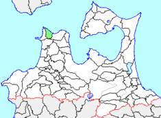
Minmaya's location in Aomori, Japan.Location Country Japan Region Tōhoku region Prefecture Aomori District Higashitsugaru District Physical characteristics Area 65.34 km² Population (as of March 1, 2005) Total 2,364 Density 36.19/km² Symbols Tree Hiba Flower Hydrangea Bird Common Gull Minmaya (三厩村 Minmaya-mura) was a village located in Higashitsugaru District in northern Aomori Prefecture, Japan.
Minmaya Village was located on the north coast of Tsugaru Peninsula bordering on Tsugaru Strait. The area was part of Hirosaki Domain during the Edo period. After the Meiji Restoration, Minmaya Village was created on April 1, 1889. On March 28, 2005 it was merged with the neighboring town of Kanita and village of Tairadate to form the new town of Sotogahama, and thus no longer exists as an independent municipality.
At the time of its merger, Minmaya had an estimated population of 2,364 and a density of 36.19 persons per km². The total area was 65.34 km². The village economy was dominated by commercial fishing. Minmaya was served by Route 339 (Japan) highway, and by Minmaya Station on the Tsugaru Line of JR East.

This Aomori Prefecture location article is a stub. You can help Wikipedia by expanding it. Categories:- Aomori geography stubs
- Dissolved municipalities of Aomori Prefecture
Wikimedia Foundation. 2010.
Look at other dictionaries:
Minmaya Station — 三厩駅 Location Prefecture Aomori (See other stations in Aomori) … Wikipedia
Aomori Prefecture — Infobox Prefecture Japan Name = Aomori JapaneseName = 青森県 Rōmaji = Aomori ken Symbol = PrefSymbol Aomori.png Capital = Aomori (city) Region = Tōhoku Island = Honshū TotalArea = 9,606.26 AreaRank = 8th PCWater = 1.2 PopDate = October 1, 2000… … Wikipedia
Aomori Station — ja stalink|Akita, ja stalink|Yamagata, and ja stalink|Niigata) *Tsugaru Kaikyō Line (for ja stalink|Kanita, ja stalink|Minmaya, ja stalink|Hakodate, and ja stalink|Sapporo) Limited express trains The following Limited express services stop at… … Wikipedia
Préfecture d'Aomori — 40°44′N 140°53′E / 40.733, 140.883 … Wikipédia en Français
Prefectura de Aomori — Para la ciudad homónima, véase Aomori (Aomori). Aomori 青森県 Aomori ken Prefectura de Japón … Wikipedia Español
Sotogahama, Aomori — nihongo|Sotogahama|外ヶ浜町|Sotogahama machi is a town located in Higashitsugaru District, Aomori of Japan.The town was founded on march 28, 2005 from the merger of the town Kanita and the villages Tairadate and Minmaya. Minmaya became a enclave from … Wikipedia
List of mergers in Aomori Prefecture — The following is a list of mergers that occurred in the 2000s in Aomori Prefecture, Japan.(as of March 1, 2006)Mergers from April 1, 1999 to March 31, 2000Mergers from April 1, 2000 to March 31, 2001Mergers from April 1, 2001 to March 31,… … Wikipedia
Higashitsugaru District, Aomori — nihongo|Higashitsugaru|東津軽郡|Higashitsugaru gun is a district located in Aomori, Japan.As of 2003, the district has an estimated population of 29,235 and a density of 44.79 persons per km². The total area is 652.72 km². Towns and villages *Hiranai … Wikipedia
Naka-Oguni Station — 中小国駅 Location Prefecture Aomori (See other stations in … Wikipedia
Ōkawadai Station — 大川平駅 Ōkawadai Station Location Prefecture … Wikipedia
