- Old Fourth Ward
-
Old Fourth Ward — Neighborhoods of Atlanta — Pubs along Edgewood Avenue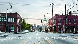 Old Fourth Ward within east-central Atlanta
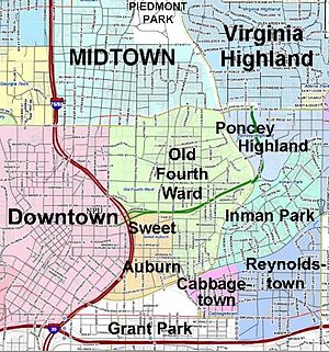
Country United States State Georgia County Fulton County City City of Atlanta Population (2000)[1] – Total 7,946 Demographics (2000)[2] – White/Other 20% – Black 75% – Asian 1% – Hispanic 5% ZIP Code 30312 Website Fourth Ward Alliance (on Facebook) The Old Fourth Ward, often abbreviated The Fourth Ward or O4W, is a neighborhood stretching 1 mile (1.6 km) east from Downtown Atlanta, Georgia. The Old Fourth Ward is one of the city's most rapidly gentrifying neighborhoods, but is also one of the city's most eclectic, containing a burgeoning nightlife district along Edgewood Avenue, the Martin Luther King, Jr. historic site, factories that have converted to lofts, buzzed-about restaurants, colorful shotgun houses in various states of renovation, gated 1980s condominium communities, and Boulevard, a street still infamous in Atlanta for its public assistance housing and drug activity.[3] In 2010, Creative Loafing awarded Old Fourth Ward "Best Bet for Next Hot 'Hood."[4] In 2011, the neighborhood celebrated the opening of the Historic Fourth Ward Park and saw the kickoff of the Ponce City Market project.
Contents
Geography
The Old Fourth Ward is defined as the area from Piedmont Ave. and Downtown Atlanta on the west, to the BeltLine and the Poncey-Highland and Inman Park neighborhoods on the east. West of Boulevard, it reaches from Ponce de Leon Avenue on the north to Freedom Parkway on the south, below which is Sweet Auburn. East of Boulevard, it reaches from Ponce de Leon Avenue on the north to the east-west MARTA rail line and Oakland Cemetery (Atlanta), and the Grant Park and Cabbagetown neighborhoods on the south. The neighborhood can be divided into two areas: north of Freedom Parkway and south of it.
North of Freedom Parkway
The area north of Freedom Parkway is one of the city's most popular up-and-coming areas. It is home The Masquerade, a music venue hosting national acts, and Historic Fourth Ward Park, a product of the BeltLine. In the very northeast corner of this area is the 2.1 million sq. ft. former Sears building, later called City Hall East, and now called Ponce City Market. Developer Jamestown plans to spend $180 million to convert it into a complex of retail, restaurants, boutiques, offices and residential space, featuring a food hall of national importance along the lines of Jamestown's own Chelsea Market in New York.[5]
South of Freedom Parkway
South of Freedom Parkway is found the largest concentration of single family houses. Auburn Avenue and Old Wheat Streets are influenced by the unique feel of Sweet Auburn. Also in this portion of the district is the Martin Luther King, Jr., National Historic Site. The Old Fourth Ward's nightlife district is located along Auburn and Edgewood Avenues.
The BeltLine
The area furthest east, along the BeltLine, is a former industrial area where rehabilitated factories and warehouses now contain some of Atlanta's best restaurants and galleries, located in complexes like Studioplex and Southern Dairies.
History
 The 1926 Sears building, now Ponce City Market
What is now the Old Fourth Ward is a smaller version of the historic Fourth Ward political area in place until the 1950s when the city changed to a district system. It is one of the oldest sections of the city, with the westernmost blocks developing soon after the Civil War.[6] Different parts of the ward were, at different times, considered white, black, or mixed-race areas. From the 1910s onward, as Atlanta politicians moved to institutionalize racially-segregated residential areas, Old Fourth Ward continued as a rich patchwork of whites living as close neighbors with blacks.
The foremost thoroughfare in today's Old Fourth Ward, Boulevard, was in the 1890s called "one of the most desirable residential streets in the city."[7] However, in the 20th century, Boulevard's grand houses gradually made way for apartment buildings.
Decline
As with most of Intown Atlanta, the Old Fourth Ward declined precipitously during the 1950s and 1960s as wealthier residents moved further out from central neighborhoods. Streets, houses and businesses that sat upon the land that is now Freedom Parkway were also razed to make way for a freeway that was never built. What was once a consistent and dense grid pattern of streets is now difficult to recognize, with Freedom Parkway occupying what had once been multiple city blocks.
Boulevard in particular witnessed a steady decline. The road is lined with apartment buildings constructed after the Great Atlanta fire of 1917, most of which are now section 8 housing. Boulevard became infamous throughout Atlanta and beyond as a haven of drug activity, prostitution, and other crime, a reputation which as of 2011 still endures despite gentrification to the north, south, east and west of the street.
Gentrification, 1980s–present
Elsewhere in the Old Fourth Ward, gentrification began in the 1980s, and continued at a more rapid pace during the first decade of the 2000s. New apartment and condo complexes with ground-floor retail sprung up, particularly along the BeltLine, Ponce de Leon Avenue, North Avenue, and Highland Avenue. New residents were attracted to the neighborhood due to its close proximity to Downtown, Midtown, Inman Park, and Virginia-Highland, its urban vibe, its walkability, and its cultural offerings. By the 2010s, Old Fourth Ward had become one of the most dynamic and sought-after areas of the city, winning Creative Loafing's 2010 award for "Best Bet for Next Hot 'Hood".[4]
Nightlife
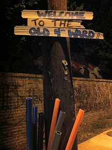 Old Fourth Ward welcome sign
After decades of neglect, Edgewood Avenue, which connects the Old Fourth Ward to downtown and Inman Park, has become a bar and restaurant district. Bar- and restaurant-owners are attracted to Edgewood's "non-corporate" feel, mostly due to its urban layout and historic buildings showcasing turn-of-the-century architecture.[8] At the intersection of Boulevard and Edgewood Avenue a concentration of hip bars and restaurants can be found.[9]
Demographics
The area, which was majority black up until 2000, has seen a huge influx of whites in recent decades. The trend began in the 1980s, and from 1980 to 2000, the area west of Boulevard went from 12% to 30% white and the area east of Boulevard went from went from 2% to 20% white.
Parks
- Freedom Parkway with its trail runs through the neighborhood
- Central Park
- Civic Center Park
- Historic Fourth Ward Park, a new park located on the site of the former Ponce de Leon amusement park
- Renaissance Park
References
- ^ http://www.arch.gatech.edu/~dapa/reports/atlneighchg/page-Images/neigh.html#Neig
- ^ http://www.arch.gatech.edu/~dapa/reports/atlneighchg/page-Images/neigh.html#Neig
- ^ Henry, Scott (2009-05-19). "Down on Boulevard: Positive change might finally come to Atlanta’s lawless street". Creative Loafing Atlanta. http://atlanta.creativeloafing.com/gyrobase/down_on_boulevard_positive_change_might_finally_come_to_atlanta_s_lawless_street/Content?oid=827931. Retrieved 2009-06-06.
- ^ a b "Best Bet For Next Hot 'Hood: Old Fourth Ward", Creative Loafing, 2010
- ^ "Slideshow: Jamestown reveals Ponce City Market", Atlanta Business Journal, June 29, 2011
- ^ Hanleiter's Directory Map of Atlanta, 1870
- ^ Severance, Margaret (1895). Official guide to Atlanta: including information of the Cotton States and International Exposition. Atlanta: Foote & Davies Co.. p. 42. http://books.google.com/books?id=gIw-AAAAYAAJ. Retrieved 2011-01-02.
- ^ http://clatl.com/atlanta/atlanta-nightlife-gold/Content?oid=1430445
- ^ Sams, Douglas. "Restaurants blossoming in Old Fourth Ward". Atlanta Business Chronicle (April 19, 2010). http://www.bizjournals.com/atlanta/stories/2010/04/19/focus13.html. Retrieved 2011-01-09.
External links
- Central Atlanta neighbors - covers north of Freedom Parkway, west of Boulevard
- Fourth Ward Alliance (on Facebook) - covers north of Freedom Parkway, east of Boulevard
- Fourth Ward Neighbors - covers south of Freedom Parkway
- Old 4th Ward Security Patrol
Neighborhoods of Atlanta, Georgia
Downtown Castleberry Hill - Fairlie-Poplar - Centennial Hill - Hotel District - Five Points - Luckie Marietta - Peachtree Center - SoNo - South DowntownMidtown Ansley Park - Atlantic Station - Colony Square - Fox Theatre Historic District - Historic Midtown - Home Park - Sherwood Forest - Technology SquareBuckhead Brookwood Hills - Buckhead Forest - Buckhead Village - Garden Hills - Historic Brookhaven - Lindbergh - Margaret Mitchell - North Buckhead - Paces - Peachtree Hills - Peachtree Park - Pine Hills - TerminusWest Midtown Blandtown - Home Park - Knight Park-Howell Station - Loring Heights - Marietta Street Artery - Underwood Hills - Westside ProvisionsEast Atkins Park - Cabbagetown - Candler Park - Druid Hills - East Atlanta - East Lake - Edgewood - Glenwood Park - Grant Park - Inman Park - Kirkwood - Lake Claire - Lindridge/Martin Manor - Little Five Points - Morningside/Lenox Park - North Ormewood Park - Oakland - Old Fourth Ward - Ormewood Park - Piedmont Heights - Poncey-Highland - Reynoldstown - Sweet Auburn - Villages of East Lake - Virginia HighlandSouth Benteen Park - Capitol Gateway - Chosewood Park - Joyland - Lakewood Heights - South Atlanta - Summerhill - Villages at CarverSouthwest Adair Park - Adamsville - Ben Hill - Capitol View - Capitol View Manor - Cascade Heights - Collier Heights - Just Us - Mechanicsville - Oakland City - Perkerson - Peoplestown - Pittsburgh - Sylvan Hills - Villages of Castleberry Hill - West End - WestviewNorthwest Bankhead - The Bluff - Center Hill - English Avenue - Grove Park - Hunter Hills - Mozley Park - Riverside - Vine City - Washington Park - West Highlands - West Lake - Whittier Mill Village
Coordinates: 33°45′16″N 84°22′20″W / 33.75431°N 84.372149°W
Categories:- Neighborhoods in Atlanta, Georgia


Wikimedia Foundation. 2010.