- McConnell Peak
-
McConnell Peak 
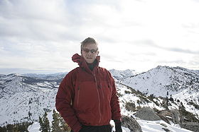
McConnell Peak is in the foreground on the right:image taken from the north...on summit of Tells PeakElevation 9,099 ft (2,773 m) NGVD 29[1] Location Location El Dorado County, California, USA Range Sierra Nevada Coordinates 38°56′55″N 120°14′35″W / 38.9485185°N 120.2429683°WCoordinates: 38°56′55″N 120°14′35″W / 38.9485185°N 120.2429683°W[2] Topo map USGS Rockbound Valley Climbing Easiest route Hike and simple scramble, class 1-2 McConnell Peak is a mountain in the Sierra Nevada mountain range at the north end of the Crystal Mountains (California), to the west of Lake Tahoe. It is located in the Desolation Wilderness in El Dorado County, California.
References
- ^ "McConnell Peak, California". Peakbagger.com. http://www.peakbagger.com/peak.aspx?pid=26370. Retrieved 2009-08-08.
- ^ "McConnell Peak". Geographic Names Information System, U.S. Geological Survey. http://geonames.usgs.gov/pls/gnispublic/f?p=gnispq:3:::NO::P3_FID:228316. Retrieved 2009-08-03.
Categories:- Mountains of the Desolation Wilderness
- El Dorado County, California geography stubs
Wikimedia Foundation. 2010.
