Popponesset Bay

Popponesset Bay
The Popponesset Bay System

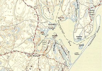
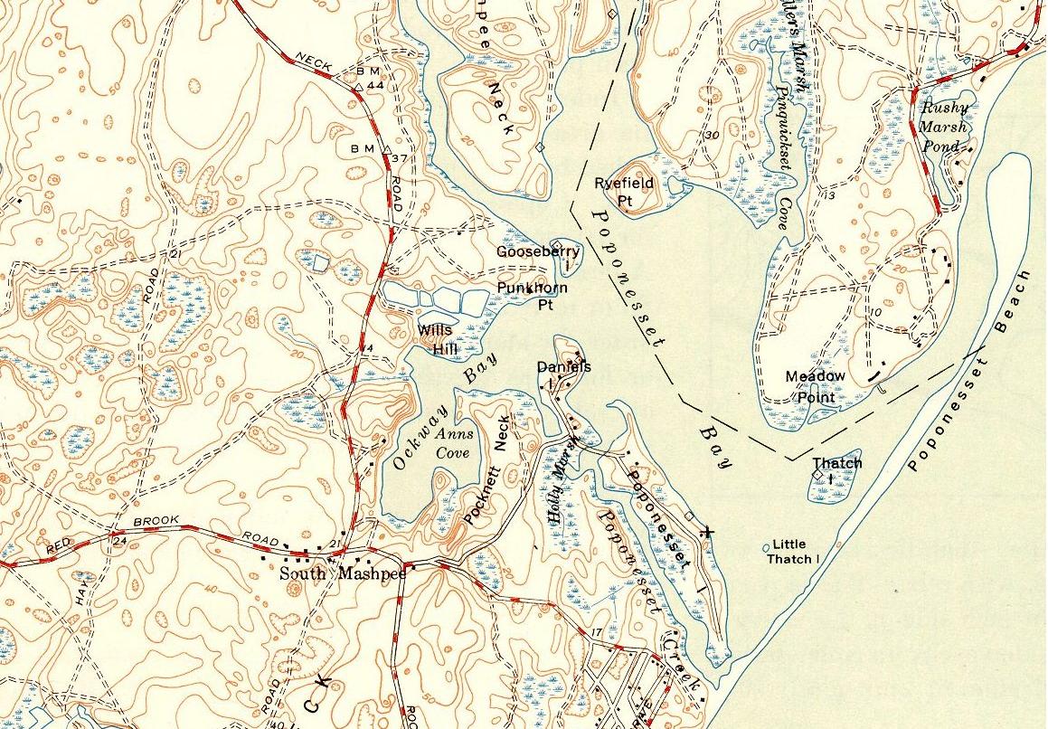
Popponesset Bay System is a group of bays located at the towns of Mashpee (north & west) and Barnstable (east), on Cape Cod, Massachusetts with a southern shore bounded by water from Nantucket Sound.

Popponesset Bay has the following tributary sub-embayments:

  • Ockway Bay
  • Shoestring Bay
  • Mashpee River Estuary
  • Pinquickset Cove

The bay system is fed by the Mashpee River and Santuit River. Popponesset Creek is not a tributary but rather connects with the bay on both ends and separates Popponesset Island from the mainland.

The bay’s watershed is distributed among the towns of Mashpee, Barnstable and Sandwich, Massachusetts. The town of Sandwich does have jurisdiction over land and associated land uses in the uppermost portions of the Popponesset Bay watershed. Portions of the Popponesset Bay watershed that exist within the Town of Sandwich are mostly situated above the Mashpee and Wakeby Ponds.

Popponesset Bay has experienced problems with eutrophication from high nitrogen loads in the groundwater and runoff from the watersheds.

The present bay results from tidal flooding of drowned river valleys formed primarily by the Mashpee and Santuit Rivers as a result of a risen sea level. The Bay is separated from Nantucket Sound by Popponesset Peninsula, a barrier spit which extends from the southwestern shore and is mostly occupied by Popponesset Beach. Popponesset Beach is known to the locals as simply "The Spit."

The bay exchanges tidal water with Nantucket Sound through a single maintained inlet. The shore to the north of the inlet has been stabilized with riprap as has the heavily residential southern portion of Popponesset Beach. The current spit is significantly shorter than seen in the 1880 Barnstable County survey.

The village of Popponesset takes its name from these waters.

References

Coordinates: 41°35′30″N 70°27′33″W / 41.59167°N 70.45917°W / 41.59167; -70.45917


Wikimedia Foundation. 2010.

Игры ⚽ Поможем сделать НИР

Look at other dictionaries:

  • Popponesset Creek — is a small waterway in Mashpee, Massachusetts on Cape Cod. On both ends, it connects with Popponesset Bay.Popponesset Creek runs from Holly Marsh down to Popponesset Peninsula and serves to separate Popponesset Island from the bay. An automobile… …   Wikipedia

  • Popponesset Peninsula — is a spit of land in Cape Cod, Massachusetts which extends from the southwestern shore of Popponesset Bay and separates it from Nantucket Sound.The peninsula is now significantly shorter than seen in the Barnstable County survey of 1880. Portions …   Wikipedia

  • Popponesset Island, Massachusetts — Infobox Settlement official name = Popponesset Island, Massachusetts settlement type = CDP nickname = motto = imagesize = image caption = image mapsize = map caption = mapsize1 = map caption1 = subdivision type = Country subdivision name = United …   Wikipedia

  • Popponesset, Massachusetts — Infobox Settlement official name = Popponesset, Massachusetts settlement type = CDP nickname = motto = imagesize = image caption = image mapsize = map caption = mapsize1 = map caption1 = subdivision type = Country subdivision name = United States …   Wikipedia

  • Mashpee, Massachusetts —   Town   Mashpee Town Hall …   Wikipedia

  • Mashpee River Reservation — is a park in Mashpee, Massachusetts on the Mashpee River. The Trustees of Reservations owns and maintains the park. Pristine shoreline, natural spawning areas, and excellent water quality make the Mashpee River one of Massachusetts finest sources …   Wikipedia

  • Santuit River — and environs The Santuit River, also known as the Cotuit River, is a 2.3 mile long (3.7 km)[1] river on the border between Mashpee and Cotuit, Massachusetts on Cape Cod. The river flows southwards from …   Wikipedia

  • Holly Marsh — is a small saltwater marshland in Mashpee, Massachusetts on the shores of Popponesset Bay, Cape Cod.The marsh starts at Daniel s Island (a peninsula) and extends down both both the mainland side and the Popponesset Island side of the Popponesset… …   Wikipedia

  • Cotuit Historic District — U.S. National Register of Historic Places U.S. Historic district …   Wikipedia

  • Mashpee River — Map of Mashpee River and environs The Mashpee River is a 4.8 mile long (7.7 km)[1] tidal river on Cape Cod in Mashpee, Massachusetts. The river arises in Mashpee and Wakeby Ponds, flows south a short …   Wikipedia

Share the article and excerpts

Direct link
Do a right-click on the link above
and select “Copy Link”