- Domab
-
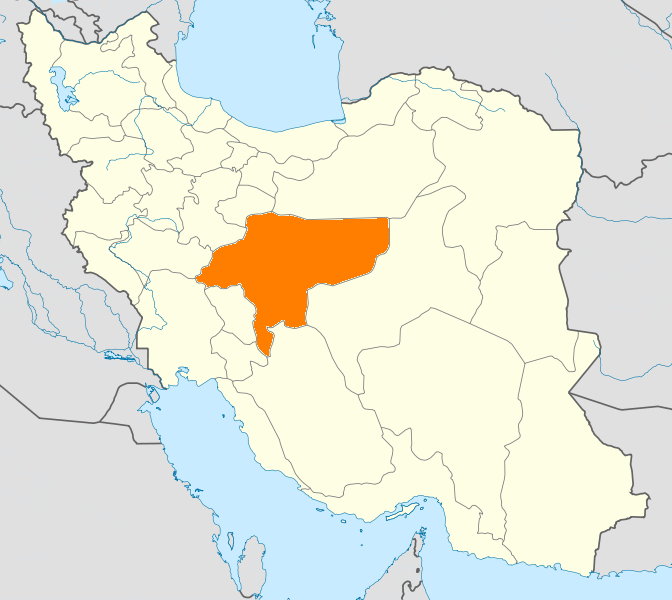
Domab is a village located in the Isfahan area of Iran, between the three cities of Khansar, Najafabad and Golpayegan. Domab is located within the Mehrdasht district of Najafabad city, approximately 2140 meters above sea level. Located on the southern slope of Dalan mountain, Domab is irrigated via seasonal rivers. Choghagodar is also nearby.
The village contains a museum with 200 artifacts, a library, computer center and film center. There is also a cultural house in the village.
History
Domab has been referred to as Sabz Darreh Morad Abad in ancient documents. At the time, the settlement of Moradabad was most likely the nearest settlement to the Domab area. The cleaning of the Domab aqueduct led to the discovery of a stone lamp with Ostad Sha’Ban 1112 engraved on it.
It is assumed that Domab became a permanent settlement between the years 1100 and 1150 A.D. The founders of the village are thought to be two brothers, named Moheb and Saleh, who began the families of Mohebian and Salehian. The farm at Domab and its surrounding region were at first rented from Dehagh.
After World War II, inflation became a problem in the region, and quarrels broke out between Domab and neighboring settlements of Eshen, Rahmatabad, and Khundub. There was also agricultural rioting, recorded in the village historical register.
Haj Hassan Domabi, said to be the son of Moheb, led the settlers of Domab to purchase the land from Dehagh. They registered the settlement as a village in the division of Isfahan.
Haj Hassan implemented the construction of foundation plans for the settlement, a local bath, and a mosque. Eventually, for the establishment of security in the region, a large castle was constructed, presumed to be the largest castle in the region. Although smaller castles had existed prior to this one, the new castle provided additional security against highwaymen and plunderers.
A few decades after this, there were internal problems in the village, due to arguments between the Mirzabi tribe and the Mohebi tribe. Externally, there were issues too; the main reasons for these arguments were economic, but also social issues as well. Lack of water and ownership rights on land contributed to these problems, but on these issues, the Mirzabi and the Mohebi banded together to defend the village.
There is a historical story about Domabian people that tells there were all with tails after the fight with Mongoliasm; However it is not true.
References
Coordinates: 33°07′N 50°43′E / 33.117°N 50.717°E
 Isfahan Province
Capital Isfahan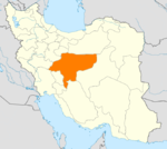
Counties (A-L)
and CitiesAran va Bidgol CountyBorkhar CountyDowlatabad • Dastgerd • Habibabad • Khvorzuq • Komeshcheh • ShahpurabadChadegan • RozvehFalavarjan • Abrisham • Baharan Shahr • Imanshahr • Kelishad va Sudarjan • Pir Bakran • Qahderijan • ZazeranFaridan CountyFereydunshahr • Barf AnbarGolpayegan • Golshahr • GugedIsfahan • Baharestan • Ezhiyeh • Harand • Hasanabad • Khvorasgan • Kuhpayeh • Mohammadabad • Nasrabad • Nikabad • Sejzi • Tudeshg • VarzanehKhomeyni Shahr CountyKhomeyni Shahr • Dorcheh Piaz • KushkKhur and Biabanak CountyKhur • JandaqKhvansar CountyKhvansarZarrin Shahr • Bagh-e Bahadoran • Chamgardan • Charmahin • Fuladshahr • Sedeh Lenjan • Varnamkhast • Zayandeh RudCounties (M-Z)
and CitiesSemirom • Hana • Komeh • VanakShahin Shahr and Meymeh CountyShahin Shahr • Gaz • Meymeh • VazvanTiran and Karun CountyTiran • Asgaran • RezvanshahrLandmarks
and
SightsSemirom waterfall • Abyaneh • Niasar fire temple • Atashgah • Babapir • Gogad citadel • Yazdgerd's palace • Grand Bazaar, Esfahan • Kashan Bazaar • Fin Garden • Khaju Bridge • Tappeh Sialk • Si-o-se Pol • Ali Qapu • Shahghandab cave • Mashhad_Ardehal ceremony • Maranjab caravansary • Hasht Behesht • Vank Cathedral • Chahar Bagh School • Qamsar rose water ceremony • Jameh Mosque of Ashtarjan • Jameh Mosque of Isfahan • Shah Mosque • Sheikh Lotf Allah Mosque • Manar Jonban • Naqsh-e Jahan Square • Narin ghaleh • Sultan Amir Ahmad Bathhouse • Agha Bozorg Mosque • Boroujerdi ha Residence • Tabatabaie Residence • House of the Āmeri family • Abbasian House • Chahar Bagh • New JulfaCategories:- Populated places in Isfahan Province
- Isfahan Province geography stubs
Wikimedia Foundation. 2010.