- Conceição do Castelo, Espírito Santo
-
Coordinates: 20°22′04″S 41°14′38″W / 20.36778°S 41.24389°W Conceição do Castelo is the name of a municipality and its capital in central Espírito Santo, Brazil. Its population was 11,146 (2005) and its area is 364,53 km².[1]
Contents
History
The municipality was created when it separated from Cachoeiro de Itapemirim on the 7th of May, 1964.
Location
Conceição do Castelo is about 120 km from the state capital Vitória. It stands in the mountainous region of the state, roughly southwest of the capital.
Economy
The economy is largely based on agriculture. Some important products are coffee, beans, maize, tomatoes and pigs, as well as cattle.
References
 Municipalities of Espírito SantoCapital: Vitória
Mesoregion Central Afonso CláudioAfonso Cláudio · Brejetuba · Conceição do Castelo · Domingos Martins · Laranja da Terra · Marechal Floriano · Venda Nova do ImigranteGuarapariSanta TeresaVitória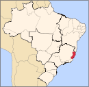
Mesoregion Litoral Norte LinharesMontanhaSão MateusMesoregion Noroeste Barra de São FranciscoColatinaNova VenéciaMesoregion Sul AlegreAlegre · Divino de São Lourenço · Dores do Rio Preto · Guaçuí · Ibatiba · Ibitirama · Irupi · Iúna · Muniz FreireCachoeiro de ItapemirimItapemirimCategories:- Municipalities of Brazil
- Populated places in Espírito Santo
- Espírito Santo geography stubs

Wikimedia Foundation. 2010.