Mantenópolis, Espírito Santo
- Mantenópolis, Espírito Santo
-
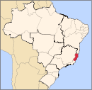
Coordinates: 18°51′46″S 41°07′22″W / 18.86278°S 41.12278°W / -18.86278; -41.12278 Mantenópolis is a municipality located in the Brazilian state of Espírito Santo. Its population was 11,115 (2005) and its area is 321 km².[1] It is a small town located in a valley with green mountains rising above it. It has a central square with municipal offices- e.g., police, public works, and school within a short walking distance of each other. There are many farms with livestock and crops in the neighboring countryside. An extraordinarily large number of people from Mantenopolis who migrate to the United States reside on the Island of Martha's Vineyard in the state of Massachusetts.
References
v · d · e Municipalities of Espírito Santo Municipalities of Espírito Santo |
|
|
Capital: Vitória
|
|
| Mesoregion Central |
|
Afonso Cláudio
|
|
|
|
Guarapari
|
|
|
|
Santa Teresa
|
|
|
|
Vitória
|
|
|
 |
|
| Mesoregion Litoral Norte |
|
Linhares
|
|
|
|
Montanha
|
|
|
|
São Mateus
|
|
|
|
| Mesoregion Noroeste |
|
Barra de São Francisco
|
|
|
|
Colatina
|
|
|
|
Nova Venécia
|
|
|
|
| Mesoregion Sul |
|
Alegre
|
|
|
|
Cachoeiro de Itapemirim
|
|
|
|
Itapemirim
|
|
|
|
Wikimedia Foundation.
2010.
Look at other dictionaries:
Espírito Santo Municipalities — Espírito Santo state ( estado in Portuguese) and all municipalities ( municípios in Portuguese) in alphabetical order.List of Espírito Santo s MunicipalitiesBy Name*Afonso Cláudio (42) *Água Doce do Norte (01) *Águia Branca (15) *Alegre (68)… … Wikipedia
Espírito Santo — Infobox Brazilian State name = State of Espírito Santo motto = Trabalha e Confia ( capital = Vitória latd= |latm= |latNS= |longd= |longm= |longEW= largest city = Vila Velha demonym = capixaba or espiritossantense leader name1 = Paulo Hartung… … Wikipedia
Marataízes, Espírito Santo — Marataizes City … Wikipedia
Mucurici, Espírito Santo — Mucurici Municipality The Municipality of Mucurici Motto: Ação e desenvolvimento (Action and development) … Wikipedia
Marilândia, Espírito Santo — Coordinates: 19°24′46″S 40°32′31″W / 19.41278°S 40.54194°W / 19.41278; 40.54194 Marilândia is a … Wikipedia
Montanha, Espírito Santo — Coordinates: 18°07′37″S 40°21′46″W / 18.12694°S 40.36278°W / 18.12694; 40.36278 Montanha is a Brazi … Wikipedia
Muqui, Espírito Santo — Coordinates: 20°57′07″S 41°20′45″W / 20.95194°S 41.34583°W / 20.95194; 41.34583 Muqui is a municipali … Wikipedia
Dores do Rio Preto, Espírito Santo — Dores do Rio Preto Municipality The Municipality of Dores do Rio Preto … Wikipedia
Conceição da Barra, Espírito Santo — Conceição da Barra Municipality The Municipality of Conceição da Barra Main church of Conceição da Barra … Wikipedia
Conceição do Castelo, Espírito Santo — Coordinates: 20°22′04″S 41°14′38″W / 20.36778°S 41.24389°W / 20.36778; 41.24389 Conceição do Cas … Wikipedia
