- Downside, Surrey
-
Coordinates: 51°18′42″N 0°24′34″W / 51.311658°N 0.409531°W
Downside 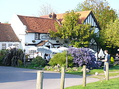
The Cricketers' Inn, Downside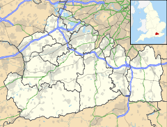
 Downside
Downside shown within SurreyOS grid reference TQ109581 District Elmbridge Shire county Surrey Region South East Country England Sovereign state United Kingdom Post town Cobham Postcode district KT11 Dialling code 01932 Police Surrey Fire Surrey Ambulance South East Coast EU Parliament South East England UK Parliament Esher and Walton List of places: UK • England • Surrey Downside is a small village in the English county of Surrey, part of Cobham and Downside ward in the local government district of Elmbridge. Downside Village was designated as a Conservation Area in 1979.[1]
A rural community, Downside is situated in open countryside between Cobham to the north and East Horsley to the south, the first such countryside out of London and part of the Green Belt. Immediately to the south of the village is the M25 motorway, where construction of a motorway service station began, despite determined local opposition, in 2011. To the north is Cobham Park, a large country house that has been converted to apartments.
 The village water pump
Downside has a large village green, on the northern edge of which is the Cricketers' Inn, dating from the 17th century and a Grade II listed building.[2] Just off the green in the south east corner is a well-preserved hand-operated water pump. At the heart of the local community are the Downside Sports & Social Club, which features regular entertainment and is always open to new members, and Downside Village Hall, which hosts classes and meetings for local groups and organisations. St. Matthew's Church of England Infant School serves the Cobham and Downside area.
The village green is the setting for the Downside & Hatchford Sports Day, held annually on August Bank Holiday Monday.
References
- ^ "Cobham Conservation Areas". cobhamheritage.org.uk. http://www.cobhamheritage.org.uk/conserv-cobhamcas.html. Retrieved November 12, 2011.
- ^ "Cricketers' Inn". britishlistedbuildings. http://www.britishlistedbuildings.co.uk/en-286704-the-cricketers-inn-esher. Retrieved November 12, 2011.
External links
- Parish Profile: Ockham with Hatchford & Downside
- Downside Village
- St. Matthew's Church of England Infant School
- The Cricketers
Towns, villages and hamlets in the Elmbridge District of Surrey, England  Claygate · Cobham · Downside · Esher · Hersham · Hinchley Wood · Long Ditton · Molesey · Oxshott · Stoke d'Abernon · Thames Ditton · Walton-on-Thames · Weybridge · Whiteley VillageCategories:
- Villages in Surrey
- Surrey geography stubs


Wikimedia Foundation. 2010.