- Claygate
-
Coordinates: 51°21′39″N 0°20′32″W / 51.3607°N 0.3421°W
Claygate
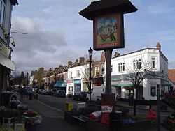
Claygate Parade and village sign,showing bricks and the Claygate Pearmain
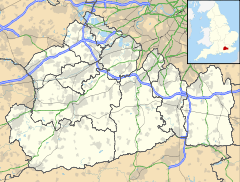
 Claygate shown within Surrey
Population 6,492 [1] OS grid reference TQ155637 Parish Claygate District Elmbridge Shire county Surrey Region South East Country England Sovereign state United Kingdom Post town Esher Postcode district KT10 Dialling code 01372 Police Surrey Fire Surrey Ambulance South East Coast EU Parliament South East England UK Parliament Esher and Walton List of places: UK • England • Surrey Claygate is a village in the English county of Surrey, approximately 16 miles (26 km) south west of London and within the Metropolitan Green Belt.
It is primarily a residential area but with offices, farms and two shopping areas with a supermarket, five pubs and numerous restaurants. There are a number of schools and churches of several denominations and a wide range of social and sporting clubs and societies.
Contents
Character
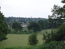
Claygate has its own parish council. Apart from a street overlap to Esher, Claygate is surrounded by woodlands and open countryside, including Claygate Common, Princes Covert, Winney Hill, Surbiton Golf Course, Telegraph Hill, Littleworth Common and Arbrook Common. Much of the intervening farmland is used for grazing ponies, but there are two active farms. The Rythe is a small river running through Claygate, and as an important drainage channel has been implicated in issues of flooding in the village. A major flood alleviation scheme was initiated in 2002.[2]
Many of Claygate's residents commute to the capital using the direct train service from Claygate railway station; the journey to central London takes 29 minutes. Claygate is also very close to the M25 and Kingston-upon-Thames. Constrained by the green belt, this has resulted in Claygate being subject to extensive in-fill and back-garden development.
Claygate is in the Parliamentary constituency of Esher and Walton, which is seen as a relatively safe seat for the Conservative Party. Local government is administered by Elmbridge Borough Council and Claygate has three representative seats on the council.
Etymology and history
Claygate took its name from the clay pits that used to be in the village, providing bricks for a large surrounding area including most of Hampton Court Palace. The village lies at the start of the broad belt of clay deposits around London - it was, literally, the "GATE-way" to the "CLAY". The Claygate Beds, the youngest layers of the London Clay, take their name from Claygate. Claygate's relative isolation has been attributed to historical conditions when through roads became impassible in wet weather because of the clay.[3]
Claygate appears in Domesday Book as Claigate. It was held by Westminster Abbey. Its domesday assets were: ½ hide; 2 ploughs, 5 acres (20,000 m2) of meadow, woodland worth 1 hog. It rendered £2 10s 0d.[4]
For many centuries Claygate was a largely agricultural area, and part of the parish of Thames Ditton. Significant commercial development began in the late nineteenth century with the coming of the railway. In 1885 a branch known as the New Guildford Line between Guildford (the county town of Surrey) and London passed through Claygate, ensuring its rapid growth over the following years. There was significant house-building particularly during the 1930s and 1960s.
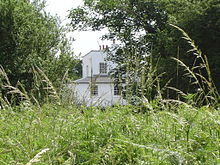
Claygate is dominated on one side by Ruxley Towers, a Victorian edifice constructed by Lord Foley who owned a considerable amount of land in the 19th Century. On the other side on Telegraph Hill is a semaphore station built in 1822 to transmit messages between the Admiralty and Portsmouth.
In about 1822 the Claygate Pearmain apple was discovered by John Braddick, growing in a hedge at Claygate.
Claygate School was established in Elm Road in 1885. The old school was closed shortly after its centenary and the Firs, formerly just the middle school, became the new single site. The original school building has been redeveloped as a Youth Centre and the Community Centre and Capelfield surgery were built on part of the site.
Commerce and services
The biggest employer in Claygate is the retail sector and there is a large and diverse selection of shops and restaurants, with two main centres known as "The Parade" and "The Old Village". The village has a very active Chamber of Commerce which funds the annual Christmas decorations in the parade and supports the Claygate Flower Show. The Parade is the larger shopping area, being adjacent to Claygate railway station and extending to shops in St Leonards Road and Hare Lane. Claygate has its own supermarket, a Post Office, two newsagents, four estate agents and a number of specialist shops. Many of the shops in Claygate are family-run, independent businesses with long histories. One of the oldest is likely to be "The Game Larder", which opened in the early 1960s as a butcher's shop called R.E. Grimes.
Claygate has five public houses, and one of the annual village traditions is a Boxing Day tour of all the pubs by Morris Dancers.
As well as the pubs, there are several restaurants in Claygate. In the "Old Village" there is a range of popular restaurants representing wide selection of international cuisine. In "The Parade" there are two fast food eateries a Chinese restaurant and a Tandoori restaurant still run by the same family since 1974, there is also a kebab shop and a fish and chip shop.
Claygate is served by the K3 Bus to Esher, Kingston and Roehampton Vale, operated by London Transport. Most properties have the Esher 01372 code, but properties right on the village boundary have been assigned the London telephone code.
Local newspapers covering Claygate include The Surrey Advertiser, The Surrey Comet and The Herald, and two freely distributed newspapers, The Informer and The Guardian. Claygate is in the editorial area of BBC Surrey, although its proximity to London means most of the capital's radio stations can be heard.
There are several small farms in Claygate, the most known being Horringdon Farm, at the end of Vale road. Many of the farms are riding centres.
Community
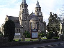
The Anglican church is "Holy Trinity", built in 1840, which is of architectural significance for having two spires. There is also a First Church of Christ Scientist. The Catholic community is served by the "Church of the Holy Name" in Arbrook Lane, Esher, with over 600 worshipping families.
There are a large number of local clubs, community groups and sports teams. One of the biggest annual events is the Claygate Flower Show which takes place on the Recreation Ground in late July each year.
The most popular monthly newspaper covering Claygate is 'Living Within'.
In the media
Filming carried out in Claygate include:
- The Loneliness of the Long Distance Runner (Tony Richardson 1961) starring Tom Courtenay, set at Ruxley Towers (Ruxton Towers in the film) and showing much of the surrounding countryside before the construction of the Esher By-pass.
- The BBC TV situation comedy Wyatt's Watchdogs which starred Brian Wilde and Trevor Bannister and was about a Neighbourhood Watch group.
- Never the Twain (1981) which used the Greek Vine frontage as the shop fronts. It starred Windsor Davies and Donald Sinden as two grumpy antique shop owners.
- A sketch for The Two Ronnies
- A shampoo commercial
- A clip from Men Behaving Badly.
- Ronnie Wood Famous Rolling Stones guitarist moved in to Ruxley towers in 2009.
Previous celebrity residents of Claygate include Terry Jones and Michael Aspel. For many years Claygate has had a number of celebrities switch on its Christmas lights. These have included Cliff Richard, Gloria Hunniford, Tony Stamp and Roger Valentine from The Bill and Bernie Nolan to name a few.
Ronnie Wood, Guitarist of the Rolling Stones lives at the highest point of Claygate, Ruxley Heights in Ruxley Tower. He can quite often be seen being driven around in his Bentley.
References
- Malcolm W H Peebles The Claygate Book: a History of a Surrey Village (1983) and Millennium edition (1999)
- Claygate Village Residents Association Claygate Village: Enquire Within (1983)
Notes
- ^ Census data
- ^ Paul McManus Battle lines drawn in sewer inquiry Get Surrey 12/11/2002
- ^ Malcolm W H Peebles The Claygate Book: a History of a Surrey Village (1983)
- ^ Surrey Domesday Book
External links
- Holy Name Church website
- Holy Trinity Church website
- Claygate Flower Show website
- 1st Claygate Scouts - Scouting in Claygate since 1909
Next station upwards Admiralty Semaphore line 1822 Next station downwards Coombe Warren Cooper's Hill
(Telegraph Hill)Chatley Heath Towns, villages and hamlets in the Elmbridge District of Surrey, England  Claygate · Cobham · Downside · Esher · Hersham · Hinchley Wood · Long Ditton · Molesey · Oxshott · Stoke d'Abernon · Thames Ditton · Walton-on-Thames · Weybridge · Whiteley VillageCategories:
- Villages in Surrey
- Elmbridge
- Civil parishes in Surrey
Wikimedia Foundation. 2010.

