- Brunet Island State Park
Geobox|Protected area
name = Brunet Island State Park
category =Wisconsin State Park
category_iucn = V
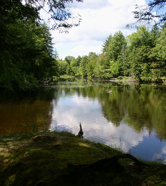
image_caption = Backwater channels at the north end of Brunet Island attract canoeists and wildlife watchers.
country = United States
country_
state = Wisconsin
state_
state_type = State
region_type = County
region = Chippewa
city_type = City
location = Cornell
lat_d = 45
lat_m = 10
lat_s = 45
lat_NS = N
long_d = 91
long_m = 9
long_s = 59
long_EW = W
area_unit = acre
area_imperial = 1225
area_round = 1
established = 1936
map_locator = Wisconsin

management_body =Wisconsin Department of Natural Resources Brunet Island State Park IPA2|ˡbɹu neɪ is a 1,200 acre (5 km²)
Wisconsin state park just north of Cornell. The park features a 169 acre (0.7 km²) island in the Chippewa River, with the remaining area on the east bank of the river. The park is noted for its numerous white-tailed deer and large eastern hemlock trees. TheOld Abe State Trail begins in the park and follows the riverbank south to the town of Chippewa Falls, with access toLake Wissota State Park .Natural history
Brunet Island is formed by the confluence of the Chippewa and Fisher Rivers. Backwater channels at the north end of the island create several undeveloped islets. The regional landscape was strongly marked by glaciation during the Wisconsinan ice period.
The park is forested with mature eastern hemlocks. Deer, overpopulated on the island, eat most of the young hemlocks. In time red pines and spruces may become dominant. Small fenced plots are scattered throughout the island to protect saplings and undergrowth from the deer. In 1977 a
tornado touched down on the north-central part of the island, leveling 18 acres. Today this area is regenerating withbirch trees.Cultural history
The park is named after Jean Brunet (1791-1877), an upper-class French immigrant who was instrumental in the development of the upper Chippewa River. He moved to
St. Louis, Missouri in 1818 and found employment with a trading company. Two years later his employers stationed Brunet inPrairie du Chien, Wisconsin , where he became a leading citizen, married, and eventually went into business for himself. Brunet formed interests in the Chippewa River Valley and moved to Chippewa Falls in 1828. There he was engaged to oversee the construction of the first dam and sawmill on the Chippewa River, which opened the region up to logging. Brunet and his wife, who were childless, took a liking to Francis Gauthier, a boy who worked for him, and treated him as an adopted son for the rest of their lives. In 1837 and 1838 Brunet served on the Wisconsin Territory legislature. Shortly thereafter Brunet moved 25 miles (40 km) upriver where he settled permanently. He engaged in trade with native people and ran a popular inn. The town of Cornell was originally called Brunet Falls in his honor.The state acquired Brunet Island in 1936 when it was donated by Northern States Power. The
Civilian Conservation Corps built a log shelter in 1938 as the park was developed, and Brunet Island State Park officially opened two years later.The 1977 tornado left so much debris that the park was closed until spring 1978 for cleanup.
Recreation
*Bicycling: Allowed on park roads and
Old Abe State Trail .
*Boating:
**Ramp for power boats and fishing boats. Boaters can access a 4 mile stretch of the Chippewa River between two dams.
**Canoes can be rented from several outfitters in Cornell and Holcombe.
*Camping:
**South Campground: 24 sites, all with electrical hookups.
**North Campground: 45 primitive sites.
*Fishing: Game fish include northern pike, walleye, small mouth bass, catfish, crappie, muskie, and yellow perch. There are fishing piers near each campground.
*Hunting: Deer hunting allowed in northern two-thirds of mainland section.
*Sports: Playground and baseball diamond at the picnic area.
*Swimming: 200 foot (60 m) swimming beach on the south end of the island.
*Trails: 8 miles (13 km) of hiking trails and 5 miles (8 km) for cross-country skiing.
**Jean Brunet Nature Trail (hiking): Interpretive trail starting near the bridge (0.8 mi).
**Timber Trail (hiking): Leads across the middle of the island from the campground to the beach.
**Pine Trail (hiking): Leads through a plantation of red pine.
**Spruce Trail (hiking): Leads along the eastern shore of the island.
**Nordic Trail (hiking, skiing): Loops through the park section on the mainland.External links
* [http://www.dnr.state.wi.us/org/land/parks/specific/brunetisland/ Brunet Island State Park website]
References
*Bartlett, W.W. "Jean Brunet devoted life to Chippewa Valley." "Eau Claire Leader": February 16, 1919. Reprinted in "Canku Ota": March 8, 2003. [http://www.turtletrack.org/Issues03/Co03082003/CO_03082003_JeanBrunet.htm]
*Wisconsin Department of Natural Resources. 2006. The Wisconsin Department of Natural Resources Web Site (online).

Wikimedia Foundation. 2010.