- Lake Wissota State Park
Geobox|Protected area
name = Lake Wissota State Park
category =Wisconsin State Park
category_iucn = V
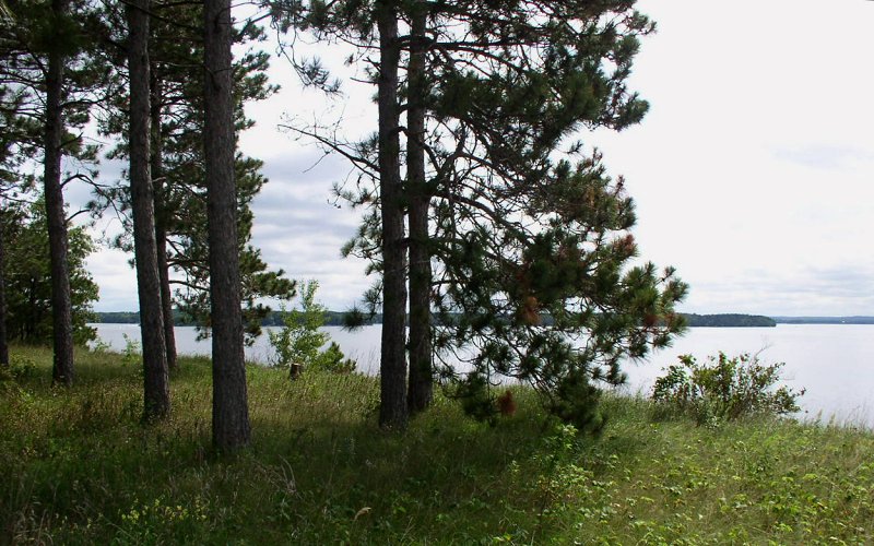
image_caption = Lake Wissota State Park's mix of prairie and forest is situated on the northeast shore ofLake Wissota .
country = United States
country_
state = Wisconsin
state_
state_type = State
region_type = County
region = Chippewa
city_type = City
location = Chippewa Falls
lat_d = 44
lat_m = 58
lat_s = 12
lat_NS = N
long_d = 91
long_m = 17
long_s = 52
long_EW = W
area_unit = acre
area_imperial = 1062
area_round = 1
established = 1961
map_locator = Wisconsin

management_body =Wisconsin Department of Natural Resources Lake Wissota State Park is a convert|1062|acre|km2|0|sing=on
Wisconsin state park near the town of Chippewa Falls. The park is situated on the northeast shore ofLake Wissota , a reservoir on the Chippewa River. Camping, boating, and fishing are the most popular activities. Park lands are covered in a mix of pine/hardwood forests and prairie. Visitors can access theOld Abe State Trail and bike or hike convert|17.5|mi|km|1 toBrunet Island State Park .Geology
The bedrock beneath the park is two billion year old
granite , which is overlain by 600 million year oldCambrian sandstone . An outcrop of this sandstone is visible south of the swimming beach. Otherwise these rock layers are blanketed by a thick layer of glacial sand and gravel. During the lastice age 15,000 years ago the Chippewa Lobe of theWisconsin glaciation ended just six miles (10 km) northeast of the park. When theglacier s melted 10,000 years ago, rock debris settled in a convert|12|mi|km|0|sing=on wide outwash plain where the park is today. The prodigious meltwater also carved the valley of the Chippewa River.History
It has been estimated that the Chippewa River Valley once contained one-sixth of the United States' white pine stands. The entire valley was extensively logged for this target species from the mid to late 1800s. Once the harvestable timber was gone farmers began settling in the cleared out land.
The Chippewa River was dammed for hydroelectric power in 1917, creating Lake Wissota.
As the sandy soil was marginal farmland, twelve landowners took advantage the federal Soil Bank Program between the mid-1950s and early 70s. This erosion-control program paid farmers to plant trees, and convert|205|acre|km2|1 here were planted with red pines. Today these trees still flank the park road near the campground.
Legislation authorizing the state park passed in 1961, championed by state senator Davis Donnelly. Wisconsin spent a decade acquiring convert|990|acre|km2|1 from various owners and developing services. The park formally opened to the public in 1972.
Flora and fauna
Lake Wissota State Park lies in the transition zone between
prairie and temperate forest. The forest itself is a mix of hardwoods such assugar maple andoak and softwoods such as red and white pine.Greatly disrupted by decades of logging and farming, these vegetative communities are healthy again after extensive
restoration ecology efforts.Controlled burn ing is conducted in the prairie. As a sustainable management model, the red pine stand is periodically thinned for maximum health. There are demonstration shoreline restoration projects near the swimming beach to educate homeowners about improving their lake frontage.Recreation
The primary attraction of Lake Wissota State Park is its access to water recreation. The unguarded convert|285|ft|m|0|sing=on swimming beach, located on a quiet arm of the lake, is very popular on summer weekends. There is a two-lane launching ramp for power boats and fishing boats. Nearby is a canoe rental and a convert|25|ft|m|0|sing=on fishing pier specially built to be handicap-accessible. Game fish in Lake Wissota include walleye, muskies, bass, panfish, northern pike, catfish, and sturgeon. Fish cribs have been dropped into the lake to provide habitat for crappies and smallmouth bass. In winter visitors can go
ice fishing for crappies, walleye, and bluegill.The family campground contains 81 wooded sites, 17 with electrical hookups. At the south end of the park are two primitive, tent-only group campgrounds. One accommodates up to 100 people and the other up to 80 people.
There are convert|17.4|mi|km|1 of summer trails, most of which allow horses and mountain bikes. The Beaver Meadow Nature Trail is a shady, one mile (1.6 km) loop with interpretive signs which passes a wetland, a fern garden, natural springs, and an ancient river bed. In winter, there are convert|9.6|mi|km|1 of trail for snowshoeing, convert|7|mi|km|0 for cross-country skiing, and convert|5|mi|km|0 for snowmobiling.
The unstaffed Karen Lea Nature Center has tables of hands-on exhibits, and there are naturalist-led programs offered during summer weekends. The park also features two baseball diamonds and a volleyball court.
External links
* [http://www.dnr.state.wi.us/org/land/parks/specific/lakewissota/ Lake Wissota State Park] official website
References
*Bailey, Bill. "Wisconsin State Parks". Glovebox Guidebooks of America: Saginaw, MI; 2000.
*Wisconsin Department of Natural Resources. Lake Wissota State Park signage, brochures, and website.

Wikimedia Foundation. 2010.