- M-67 (Michigan highway)
-
This article is about the state highway in Michigan; for other uses, see M67 (disambiguation)
M-67

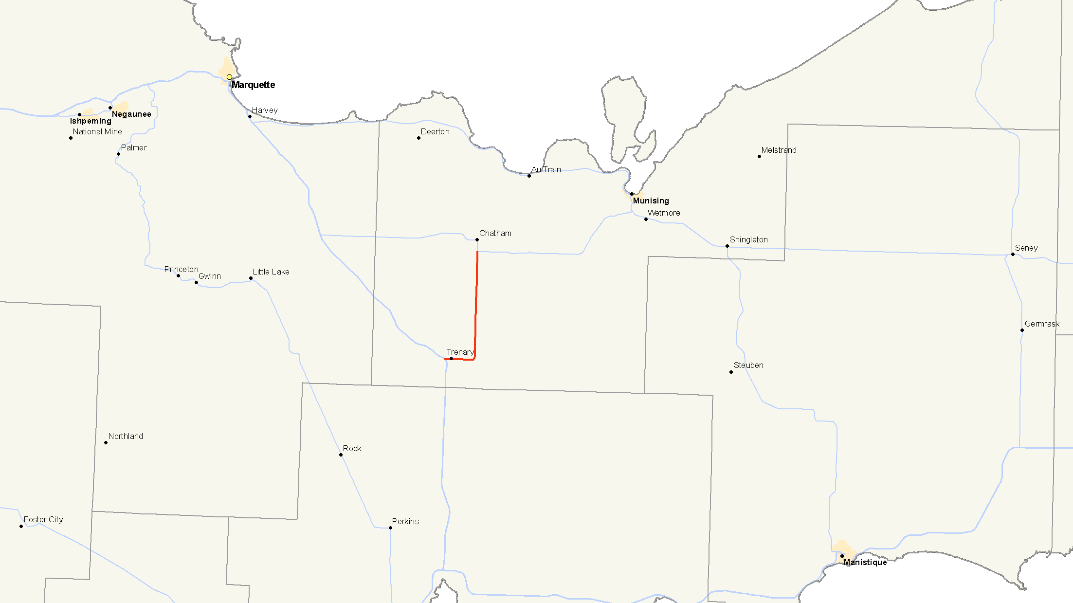
M-67 highlighted in redRoute information Maintained by MDOT Length: 12.044 mi[2] (19.383 km) Existed: 1919[1] – present Major junctions South end:  US 41 in Trenary
 H-44 in Limestone
North end:  M-94 in Chatham
Location Counties: Alger Highway system Michigan State Trunkline Highway System
Interstate • US • State←  M-66
M-66M-68  →
→M-67 is a north–south state trunkline highway in the Upper Peninsula of the U.S. state of Michigan. It connects with US Highway 41 (US 41) and M-94 between Trenary and Chatham. The highway has largely been unchanged during its history, although the highways that connect to M-67 on each end have changed several times.
Contents
Route description
M-67 starts at an intersection with US 41 near Trenary east of the West Branch of the Whitefish River. From that intersection the highway runs east crossing Scott Creek before running into downtown Trenary along relatively flat terrain. East of town, the highway turns north running parallel to the AuTrain River Basin. The trunkline crosses Dexter Creek between Paulsen and Trout Lake roads.[3] About halfway along the north–south segment of the highway, M-67 passes through the community of Limestone and crosses Johnson Creek. After running for 12.044 miles (19.383 km), M-67 ends at a four-way intersection with M-94 and Tunteri Road.[2][3]
Michigan Department of Transportation (MDOT) traffic surveys in 2007 show that between 1,200 and 1,400 vehicles traveled the road daily in 2007 in a measure of the annual average daily traffic (AADT).[4] The same surveys showed that only 90 trucks are included in that average.[5] In comparison, US 41 south of M-67 carried an average of 2,300 vehicles and 270 trucks.[4][5] No segment of the trunkline is listed on the National Highway System, a system of strategically important highways.[6]
History
M-67 is an original state trunkline dating back to 1919.[1] Its routing has been largely unchanged since designation. The southern terminus has been moved once, but the northern terminus has remained in the same location since 1919. US 41 was rerouted in the Trenary area to run west of town in late 1937 and 1938. M-67 was extended westerly along a former portion of US 41 to connect to the new highway on the south end of M-67.[7][8]
While the highway itself is largely unchanged since 1919, the connections with other trunklines have changed. The intersection south of the community of Chatham where M-67 has ended since designation has remained unchanged. The other highways running through the intersection have changed twice. The first highway to connect with M-67 was M-25.[1] M-25 was replaced by M-28 in 1927.[9] The second change came in 1941 when the routings of M-28 and M-94 were exchanged between Harvey and Munising.[10][11]
The original southern terminus was at an intersection with M-15 in Trenary.[1] In 1926, M-15 was replaced by US 41.[12] As stated previously, the southern terminus of M-67 was shifted to a new intersection with US 41 west of Trenary when the latter was rebuilt in the late 1930s resulting in the only physical change to M-67's routing.[7][8]
Major intersections
The entire highway is in Alger County.
Location Mile[2] Destinations Notes Trenary 0.000 US 41 – Marquette, Rapid River0.621  H-01 – Traunik
Southern terminus of H-01 Limestone 7.032 H-44 – TraunikEastern terminus of H-44, western segment Chatham 12.044 M-94 – Skandia, Munising1.000 mi = 1.609 km; 1.000 km = 0.621 mi References
- ^ a b c d Michigan State Highway Department (1919). State of Michigan: Upper Peninsula (Map). Cartography by MSHD. http://maps.lib.msu.edu/miroadmaps/1919_up.htm. Retrieved March 2, 2008.
- ^ a b c "MDOT Physical Reference Finder Application". Michigan Department of Transportation. 2009. http://www.mcgi.state.mi.us/prfinder/. Retrieved April 10, 2010.
- ^ a b Google, Inc. Google Maps – Overview Map of M-67 (Map). Cartography by Google, Inc. http://maps.google.com/maps?saddr=US-41+%26+M-67,+MI&geocode=&dirflg=&daddr=M-67+%26+M-94,+Chatham,+MI&f=d&sll=46.195027,-86.983018&sspn=0.009447,0.014334&ie=UTF8&t=p&z=12. Retrieved October 7, 2008.
- ^ a b Michigan Department of Transportation (2007). Statewide AADT Map (Map). http://www.michigan.gov/documents/adtfront_20092_7.pdf. Retrieved October 7, 2008.
- ^ a b Michigan Department of Transportation (2007). Commercial Statewide AADT Map (Map). http://www.michigan.gov/documents/cadtfront_19920_7.pdf. Retrieved October 7, 2008.
- ^ Michigan Department of Transportation (April 23, 2006) (PDF). National Highway System, Michigan (Map). http://www.michigan.gov/documents/MDOT_NHS_Statewide_150626_7.pdf. Retrieved October 7, 2008.
- ^ a b Michigan State Highway Department (May 15, 1937). 1937 Official Michigan Highway Map (Map). Cartography by Rand McNally (Summer ed.).
- ^ a b Michigan State Highway Department (December 1, 1938). 1938 Official Michigan Highway Map (Map). Cartography by Rand McNally (Winter ed.).
- ^ Michigan State Highway Department (December 1, 1927). Official Highway Service Map (Map).
- ^ Michigan State Highway Department (March 21, 1941). 1941 Official Michigan Highway Map (Map). Cartography by Rand McNally (Spring ed.).
- ^ Michigan State Highway Department (July 1, 1941). 1941 Official Michigan Highway Map (Map). Cartography by Rand McNally (Summer ed.).
- ^ Bureau of Public Roads (1926). United States System of Highways (Map). http://en.wikipedia.org/wiki/Image:1926us.jpg. Retrieved May 10, 2008.
External links
Categories:- State highways in Michigan
- Transportation in Alger County, Michigan

Wikimedia Foundation. 2010.