- Atlantic Beach Bridge
-
Atlantic Beach Bridge 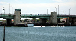
Carries New York SR-878 (Nassau Expy) Crosses Reynolds Channel Design Bascule girder Material Steel Total length 1,173 feet (358 m) Clearance below 33-foot (10 m) Construction begin October 14, 1950 Construction cost $9.5 million Opened May 10, 1952 Toll $2 The Atlantic Beach Bridge is a 153-foot (47 m) long toll drawbridge connecting Lawrence (SR-878) and Atlantic Beach (Park Street), NY while passing over the west end of Reynolds Channel. The bridge also provides direct access to the Rockaway Peninsula via Seagirt Boulevard.
The toll is $2.00 (USD) in each direction as of January 1, 2007. E-ZPass is not accepted. An annual decal for Nassau County residents is $130.00 USD.[1]
Contents
History
The original bridge opened on June 29, 1927 and had a vertical clearance of only 13 feet (4.0 m). Traffic bottlenecked as populations grew on both sides of the bridge in the 1940s. On October 14, 1950, Governor Thomas E. Dewey drove the first pile for the new Atlantic Beach Bridge. To accommodate the new six-lane span, Nassau County and New York City spent $2.5 million for approach road rights-of-way. The new Atlantic Beach Bridge opened to traffic on May 10, 1952, at a cost of $9.5 million. Soon after the new span opened, the old bridge was demolished. It was and is now 1,173 feet (358 m) long with a 33-foot (10 m) vertical clearance.[2][3][4]
Reconstruction
In 1998, a $19 million project was begun to bring the bridge up to federal standards. It involved the reconstruction of the approaching roadways and replacement of the existing concrete bridge deck. The project was completed in November 2000.[2]
Bridge Authority controversy
There have been allegations of patronage since the inception of the Nassau County Bridge Authority, which was created by the New York Legislature in 1945 to manage the bridge. Though the construction costs of the bridge have long since been paid off, the tolls remain. A 1999 audit of the agency by New York State Comptroller Carl McCall found many instances of patronage and mismanagement. The authority failed to seek competitive work for engineering work. In 1997, 71% of the bridges budget was spent on personnel.[5]
References
- ^ http://ncbaabb.com/FARE%20SCHEDULE.pdf Official fare chart, Nassau County Bridge Authority
- ^ a b Atlantic Beach Bridge, NYCRoads.com. Accessed October 29, 2007.
- ^ "Atlantic Beach Bridge; New Long Island Structure to Be Officially Opened June 29". The New York Times: p. E10. June 26, 1927. http://select.nytimes.com/gst/abstract.html?res=FB081EFD3D5812738DDDAF0A94DE405B878EF1D3. Retrieved April 13, 2010.
- ^ Kihss, Peter (May 11, 1952). "New Span Opened at Atlantic Beach". The New York Times: p. 55. http://select.nytimes.com/gst/abstract.html?res=F60912F73B5E107A93C3A8178ED85F468585F9. Retrieved April 13, 2010.
- ^ Ain, Stewart (July 25, 1999). "Atlantic Beach Bridge: Tolls, Jobs and Politics". The New York Times. http://query.nytimes.com/gst/fullpage.html?res=9400E7D8163EF936A15754C0A96F958260. Retrieved October 29, 2007.
External links
 Greater Long Beach
City & Island
CommunitiesGeography Long Beach Barrier Island • Outer Barrier • Reynolds ChannelPublic Services Fire • Hospital • PoliceEducation Transportation Rail and bus terminal • LIRR Long Beach Branch • Long Beach Bus
Atlantic Beach Bridge • Long Beach Bridge • Loop ParkwayCoordinates: 40°35′36″N 73°44′14″W / 40.59333°N 73.73722°W
Categories:- Transportation in Nassau County, New York
- Toll bridges in New York
- Bridges completed in 1927
- Bascule bridges
- Bridges on Long Island, New York
- Road bridges in New York

Wikimedia Foundation. 2010.