- Magnis (Carvoran)
-
This article is about the Roman fort on Hadrian's Wall. For the Roman town in Herefordshire, see Magnis (Kenchester).
Coordinates: 54°59′06″N 2°31′28″W / 54.9849°N 2.5244°W
Magnis (Carvoran) 
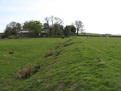
North boundary of the fort, with the Roman Army Museum in the background
 Magnis (Carvoran) shown within Northumberland
OS grid reference NY665656 List of places: UK • England • Northumberland Magnis (or Carvoran Roman Fort) was a fort on Hadrian's Wall, in the Roman province of Britannia. Magnis was originally built to guard the junction of the northbound Maiden Way with the Stanegate, the key supply route linking Coria (Corbridge] in the east to Luguvalium (Carlisle) in the west. As such it pre-dates Hadrian's Wall. Its ruins are located at Carvoran in the civil parish of Greenhead in the English county of Northumberland. Magnis is one of 16 Roman forts along Hadrian's Wall; there are also 80 smaller milecastle forts and 158 turrets along its length. The Maiden Way Roman road runs south from Magnis to Kirkby Thore near Penrith.
Artifacts recovered at Magnis include a 2-foot-long (0.61 m) iron spearhead, found at a depth of 36 feet (11 m) in a well, and the well-known modius, a bronze grain-measure.[1] Magnis is the location of the Roman Army Museum run by the Vindolanda Trust. Directions can be found on the website Vindolanda and Roman Army Museum
References
- ^ John Collingwood Bruce, The Roman wall, 1853
External links
- http://www.roman-britain.org/places/magnis_carvetiorum.htm Magnis Carvetiorum
- CARVORAN FORT at hadrianswallcamera.co.uk
Wall Forts (East to West) Segedunum • Pons Aelius • Condercum • Vindobala • Onnum • Cilurnum • Procolita • Vercovicium • Aesica • Magnis • Banna • Camboglanna • Uxelodunum • Aballava • Coggabata • MaiaOutpost Forts Stanegate Forts Corstopitum • Newbrough • Vindolanda • Haltwhistle Burn • Magnis • Throp • Nether Denton • Castle Hill Boothby • Brampton Old Church • LuguvaliumSupply Forts Roman visitor sites in the UK Villas Bignor • Brading • Chedworth • Crofton • Dover Painted House • Littlecote • Lullingstone • Fishbourne • Newport • Piddington • Rockbourne • WroxeterForts & Military Arbeia • Binchester • Birdoswald • Caerleon • Chesters • Housesteads • Lunt • Carvoran Roman Army Museum • Pevensey Castle • Portchester Castle • Richborough • Segedunum • VindolandaTowns Roman Museums Canterbury Roman Museum • Carvoran Roman Army Museum • Corinium Museum • Jewry Wall Museum • Ribchester • Senhouse Roman Museum • Trimontium Trust (Melrose) • Verulamium MuseumOther sites Bath Roman Baths • Caerleon Roman Baths • Verulamium Roman Theatre • Welwyn Roman Baths • York Roman BathsCategories:- Forts of Hadrian's Wall
- History of Northumberland
- Roman sites in Northumberland
- Military museums in England
- Northumberland geography stubs
Wikimedia Foundation. 2010.


