- Condercum
-
Coordinates: 54°58′34″N 1°39′47″W / 54.976°N 1.663°W
Condercum 
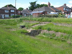
The Vallum crossing at Condercum
 Condercum shown within Tyne and Wear
OS grid reference NZ216646 List of places: UK • England • Tyne and Wear Condercum was a Roman fort at modern-day Benwell, a suburb of Newcastle upon Tyne, England. It was the third fort on Hadrian's Wall, after Segedunum (Wallsend) and Pons Aelius (Newcastle), and was situated 2 miles (3 km) to the west of the city. Today, nothing can be seen of the fort or its adjoining wall, as the site is covered by buildings and is crossed by the A186 Newcastle to Carlisle road. The remains of a small temple dedicated to Antenociticus, a local deity, can be seen nearby, and the original causeway over the vallum, or ditch, can also be seen.
Contents
Description

This article is part of the series on:
Military of ancient Rome (portal)
753 BC – AD 476Structural history Roman army (unit types and ranks, legions, auxiliaries, generals) Roman navy (fleets, admirals) Campaign history Lists of wars and battles Decorations and punishments Technological history Military engineering (castra, siege engines, arches, roads) Political history Strategy and tactics Infantry tactics Frontiers and fortifications (limes, Hadrian's Wall) The remains of the fort lie on Hadrian's Wall to the west of Newcastle. The fort measured 570 feet (170 m) from north to south by 400 feet (120 m) east to west and the defences enclosed an area of just over 5 acres (2.0 ha). It was a cavalry fort, and had three gates leading to the north of the wall. There were two side gates, facing east and west, through which the Roman military road, running along the south side of the wall, entered and exited. There was also a south-facing gate that led to a causeway that crossed the vallum. The causeway had a gateway, halfway across which was closed by doors. The fort contained a commandant’s house, headquarters, two granaries, workshops, barracks, stables and a hospital.
Construction and garrison
It is known from several building inscriptions that the defences of the fort at Benwell were built by soldiers from the Second Augustan Legion (Legio II Augusta). It is believed that it was built between 122 AD and 124 AD. Soldiers from the Twentieth Legion (Legio XX Valeria Victrix) were apparently responsible for some additional building or repair work at Benwell in the late-2nd century.
The fort contained two granaries, and it is known that these were built by a detachment from the British Fleet, probably because the legionnaires responsible for construction of the fort had been called away. It is likely that the detachment was sent from nearby Arbeia, in modern-day South Shields.
In the 2nd century Condercum was garrisoned by the Cohors I Vangionum Milliaria Equitata, which was a part-mounted unit from Upper Germany. This had a nominal strength of one thousand men, but it is likely that only half of this number occupied the fort. It is thought that from AD 205 to AD 367, a five-hundred-strong auxiliary cavalry unit (Ala Primae Hispanorum Asturum), from the Astures tribe in northern Spain, was stationed at the fort.
Other buildings
There is evidence that a village, or vicus, grew up around the fort, lying to the north and south of the vallum. The remains of three notable buildings were found near the fort.
A number of altar-stones have been found at the site, dedicated to various gods. Three of the altars were dedicated to Antenociticus, who is believed to be a Celtic deity.
A hundred yards to the east of the fort, the remains of a temple dedicated to Antenociticus, believed to be a local Celtic deity, can still be seen. The building, which was discovered in 1862, measures 15 feet (4.6 m) from east to west and 20 feet (6.1 m) from north to south, with an apse extending a further six feet on the south end. It is believed that the apse contained a life-size statue of the god, as a full size head was found, together with the fragments of an arm and a leg. The head was adorned with a Celtic neck torc. The temple also contained three altars to Antenociticus.
Three hundred yards to the southwest of the fort, a bathhouse was discovered in 1751. The building had several rooms, which were probably the hot and cold rooms and dressing rooms normally found in such bathhouses.
Just south of the vallum causeway, a third building was found. This was a large domestic building, believed to be a mansio, or resthouse for official travellers.
References
- J. Collingwood Bruce, Handbook to the Roman Wall (1863), Harold Hill & Son, ISBN 0 90046 332 5
- Ronald Pemberton and Frank Graham, Hadrian’s Wall in the Days of the Romans (1984), Frank Graham, ISBN 0 85983 177 9
External links
- CONDERCUM FORT on the line of Hadrian's Wall as it exists today
- Hadrian's Wall Fort and Settlement
- Hadrian's Wall - Condercum ~ Salve ad Condercum ( Benwell )
Wall Forts (East to West) Segedunum • Pons Aelius • Condercum • Vindobala • Onnum • Cilurnum • Procolita • Vercovicium • Aesica • Magnis • Banna • Camboglanna • Uxelodunum • Aballava • Coggabata • MaiaOutpost Forts Stanegate Forts Corstopitum • Newbrough • Vindolanda • Haltwhistle Burn • Magnis • Throp • Nether Denton • Castle Hill Boothby • Brampton Old Church • LuguvaliumSupply Forts Categories:- Forts of Hadrian's Wall
- Roman forts in England
- Former populated places in England
Wikimedia Foundation. 2010.


