- Ypati
-
For the muse, see Hypate.
Ypati
Υπάτη
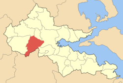
Location Coordinates 38°52′N 22°14′E / 38.867°N 22.233°ECoordinates: 38°52′N 22°14′E / 38.867°N 22.233°E Government Country: Greece Region: Central Greece Regional unit: Phthiotis Municipality: Lamia Population statistics (as of 2001) Municipal unit - Population: 6,855 - Area: 263 km2 (102 sq mi) - Density: 26 /km2 (68 /sq mi) Other Time zone: EET/EEST (UTC+2/3) Auto: ΜΙ Ypati (Greek: Υπάτη) is a village and a former municipality in Phthiotis, Greece. Since the 2011 local government reform it is part of the municipality Lamia, of which it is a municipal unit.[1] Its 2002 population was 6,855 for the municipality. In the Middle Ages and the Ottoman period, it was known as Neopatras (Νέαι Πάτραι, "New Patras"), colloquially also Patratziki (Πατρατζίκι), and was the capital of the Duchy of Neopatria.
Contents
Subdivisions
The municipal unit Lidoriki is subdivided into the following communities (constituent villages in brackets):
- Argyrochori
- Dafni
- Kastanea (Kastanea, Kapnochori)
- Kompotades
- Ladikou
- Loutra Ypatis (Loutra Ypatis, Varka, Magoula, Nea Ypati)
- Lychno (Lychno, Alonia)
- Mexiates
- Mesochori Ypatis
- Neochori Ypatis
- Peristeri
- Pyrgos
- Rodonia (Rodonia, Karya)
- Syka Ypatis
- Vasiliki
- Ypati (Ypati, Amalota)
Population
Year Village Municipal district Municipality 1991 - 929 6,795 2001 724 849 6,855 Geography
Ypati is around 30 km west of Thermopylae and north of the Oiti mountains and Xerisa river, it is also 25 km west of Lamia south of the GR-38 (Lamia - Karpenissi - Agrinio), around 230 km NNW of Athens and about 50 km east of Karpenissi, it overlooks the Spercheios to the north. The geography includes forests and grasslands to the south in higher elevations. Neighbouring municipalities includes Sperchiada, Makrakomi, Leianokladi, Lamia, Gorgopotamos, Pavliani and Kallieis. Phocis lies to the south. Around 3 km northwest are the famous springs which dates to the ancient times. It is around a few kilometres from the mountains.
History
Antiquity
In Antiquity, the city was known as Hypate (Ὑπάτη) or Hypata (Ὓπατα), probably a corruption of hypo Oita (ὑπὸ Οἴτα, meaning "near the Mount Oeta"). The city was founded in 410 BC by the Aenianians, who at the time settled in southern Phthiotis. In later times it belonged to the Amphictyony of Amphela. Herodotus records the nearby hot springs, which were visited in Antiquity. The city played a role in the repulsion of the Celtic invasion of Greece in 279 BC, as an assembly point for the forces of the Aetolian League.
In the Roman period, it was part of the Roman province of Achaea. Christianity arrived in the 1st century AD; tradition names St. Herodion of Patras as the city's first bishop. Archaeological findings from the 2nd century AD indicate a relative prosperity during that period.
Byzantine, medieval and Ottoman eras
The city is mentioned in the 6th century by Procopius (who recorded repairs to its walls by Emperor Justinian I) and in the Synecdemus.[2] The city may have been abandoned after the Slavic invasions of the 7th century, and reappears in the 10th century under the name Neai Patrai ("New Patras") or Patrai Helladikai ("Patras in [the theme of] Hellas"). Until the 13th century, the city is mentioned only as an ecclesiastical center, being a metropolitan bishopric with one (10th century) and eventually twelve (12th century) suffragans.[2]
The city played a major role in the latter 13th century, when it was the capital of the independent rulers of Thessaly like John I Doukas. The Catalan Company seized the city in 1319 and made it the centre of the new Duchy of Neopatria, a vassal of the Duchy of Athens. It was one of the last remaining Catalan possessions, and fell to the Ottoman Turks in 1394.[2]
Under Ottoman rule, the city became known as Patracık ("Little Patras"), rendered in Greek as Patratziki (Πατρατζίκι). The Turks were evicted for a time, in 1402, by Theodore Palaiologos, Despot of the Morea. The Turks recovered it in 1414, the Byzantines in 1416, until it was definitively conquered by the Ottomans in 1423.[3]
Revolutionary period
In the Greek War of Independence, Ypati (Patratziki) was the scene of three battles:
- On 18 April 1821, when the Turkish-held town was attacked by the Greek rebels under Mitsos Kondogiannis, Dyovouniotis, Athanasios Diakos and Bakogiannis. The garrison was defeated and negotiations for its surrender began, but the arrival of a large Turkish relief army forced the rebels to withdraw.[3]
- In May 1821, the Greek commanders Yannis Gouras, Skaltsodimos and Safakas intended to attack the town in order to halt the Ottoman advance towards Livadeia. Their forces however were attacked first, and although they beat back the Turkish assault, the plans to take the town were dropped.[3]
- On 2 April 1822, when the town itself was finally taken by the forces of the captains Kondogiannis, Panourgias, Skaltsas and Safakas. The castle however, with its 1,500-strong garrison, held out. A final attack against it was successful, evicting the garrison, but again the revoluionaries had to withdraw due to the arrival of Ottoman reinforcements from Lamia.[3]
Ypati finally joined Greece in 1830 and revived its ancient name. The municipality of Ypati was founded on January 10, 1834.
Modern era
The town suffered during the Axis occupation: 15 inhabitants were shot as reprisals for the Gorgopotamos sabotage in 1942, while on 14 June 1944, the Germans surrounded the town, executed 28 people and burned down 375 out of 400 buildings.
External links
Northwest: Makrakomi Ypati East: Lamia South: Kallieis Southeast: Gorgopotamos References
- ^ Kallikratis law Greece Ministry of Interior (Greek)
- ^ a b c Kazhdan, Alexander, ed. (1991), Oxford Dictionary of Byzantium, Oxford University Press, p. 1454, ISBN 978-0-19-504652-6
- ^ a b c d (in Greek) Τουρκοκρατία - Επανάσταση, Municipality of Ypati, http://www.ypati.gr/article.php?c=9&a=43, retrieved 21 May 2010
Categories:- Populated places in Phthiotis
Wikimedia Foundation. 2010.


