- Haines Airport
-
Haines Airport 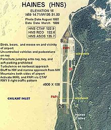
IATA: HNS – ICAO: PAHN – FAA LID: HNS Summary Airport type Public Owner State of Alaska DOT&PF - Southeastern Region Serves Haines, Alaska Elevation AMSL 15 ft / 5 m Coordinates 59°14′38″N 135°31′25″W / 59.24389°N 135.52361°WCoordinates: 59°14′38″N 135°31′25″W / 59.24389°N 135.52361°W Map Location of airport in Alaska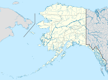
 HNS
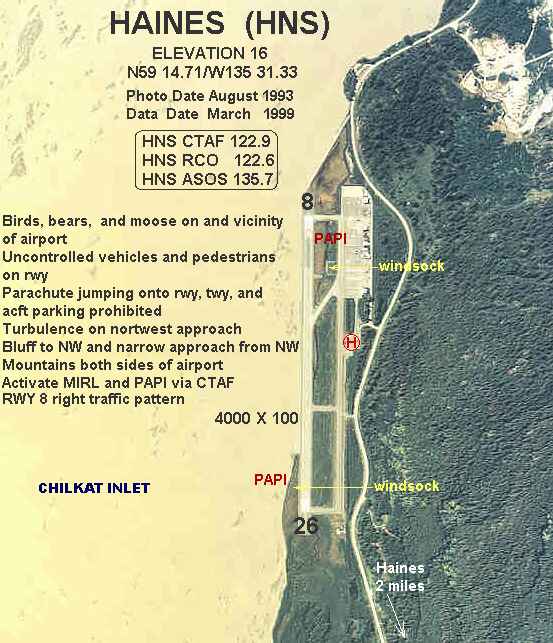
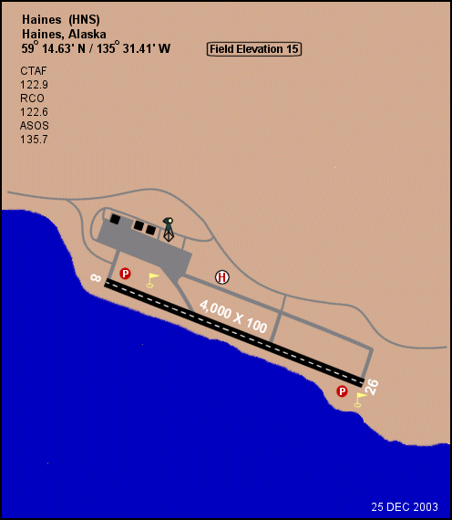
HNSRunways Direction Length Surface ft m 8/26 4,000 1,219 Asphalt Statistics (2006) Aircraft operations 5,700 Source: Federal Aviation Administration[1]  Diagram of Haines Airport (HNS)
Haines Airport (IATA: HNS, ICAO: PAHN, FAA LID: HNS) is a state-owned public-use airport located three nautical miles (6 km) west of the central business district of Haines,[1] a city in the Haines Borough in the U.S. state of Alaska. It is the primary airport serving the Haines, Klukwan, Haines Borough area and is situated on the Haines Highway, directly adjacent to the Chilkat River.
This airport is included in the National Plan of Integrated Airport Systems for 2011–2015, which categorized it as a non-primary commercial service airport.[2] As per Federal Aviation Administration records, the airport had 7,035 passenger boardings (enplanements) in calendar year 2008,[3] 7,099 enplanements in 2009, and 9,534 in 2010.[4]
Contents
Facilities and aircraft
Haines Airport covers an area of 124 acres (50 ha) at an elevation of 15 feet (5 m) above mean sea level. It has one runway designated 8/26 with an asphalt surface measuring 4,000 by 100 feet (1,219 x 30 m).[1]
For the 12-month period ending December 31, 2006, the airport had 5,700 aircraft operations, an average of 15 per day: 79% air taxi, 19% general aviation, and 2% military.[1]
Airlines and destinations
The following airlines offer scheduled passenger service at this airport:
Airlines Destinations Air Excursions Juneau, Skagway[5] Wings of Alaska Juneau, Skagway Carrier shares for August 2010 - July 2011[6] Carrier Passengers (arriving and departing) SeaPort 7,650(40.96%)Wings of Alaska 7,640(40.92%)Excursions 3,390(18.12%)Top domestic destinations
(August 2010 - July 2011)[6]Rank City Airport Passengers 1 Juneau, AK JNU 8,000 2 Skagway, AK SGY 2,000 See also
- Haines Seaplane Base
- List of airports in Alaska
References
- ^ a b c d FAA Airport Master Record for HNS (Form 5010 PDF). Federal Aviation Administration. Effective 25 August 2011.
- ^ "2011–2015 NPIAS Report, Appendix A (PDF, 2.03 MB)". National Plan of Integrated Airport Systems. Federal Aviation Administration. 4 October 2010. http://www.faa.gov/airports/planning_capacity/npias/reports/media/2011/npias_2011_appA.pdf.
- ^ "Enplanements for CY 2008 (PDF, 1.0 MB)". CY 2008 Passenger Boarding and All-Cargo Data. Federal Aviation Administration. 18 December 2009. http://www.faa.gov/airports/planning_capacity/passenger_allcargo_stats/passenger/media/cy08_all_enplanements.pdf.
- ^ "Enplanements for CY 2010 (PDF, 5.4 MB)". CY 2010 Passenger Boarding and All-Cargo Data. Federal Aviation Administration. 4 October 2011. http://www.faa.gov/airports/planning_capacity/passenger_allcargo_stats/passenger/media/cy10_all_enplanements.pdf.
- ^ "Destinations". Air Excursions. http://www.airexcursions.com/destinations.htm. Retrieved 27 October 2011.
- ^ a b "Haines, AK: Haines Airport (HNS)". Bureau of Transportation Statistics. July 2011. http://www.transtats.bts.gov/airports.asp?pn=1&Airport=HNS&End_YearMonth=24139.
External links
- FAA Alaska airport diagram (GIF)
- Topographic map from USGS The National Map
- Resources for this airport:
- AirNav airport information for PAHN
- ASN accident history for HNS
- FlightAware airport information and live flight tracker for PAHN
- NOAA/NWS latest weather observations for PAHN
- SkyVector aeronautical chart for HNS
Categories:- Airports in Haines Borough, Alaska

Wikimedia Foundation. 2010.