Jerry Tyler Memorial Airport

Jerry Tyler Memorial Airport
IATA: noneICAO: noneFAA LID: 3TR
Summary
Airport type Public Use
Operator City of Niles, Michigan
Serves City of Niles, Michgan
Location Niles, Michigan
Elevation AMSL 750 ft / 228.6 m
Coordinates 41°50′27″N 86°13′33″W / 41.8407°N 86.2259°W / 41.8407; -86.2259Coordinates: 41°50′27″N 86°13′33″W / 41.8407°N 86.2259°W / 41.8407; -86.2259
Website City of Niles website
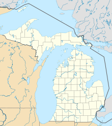
Map
Jerry Tyler Memorial Airport is located in Michigan
Location within Michigan
Runways
Direction Length Surface
ft m
(15/33) 4,100 1,250 Concrete
(4/22) 3,315 1,010 Concrete
Source: AirNav[1]

Jerry Tyler Memorial Airport (FAA LID: 3TR) in Niles, Michigan is a privately held company categorized under Airports. Current estimates show this company has an annual revenue of less than $500,000 and employs a staff of five to nine people.

The airport has spent most of its time without commercial air service (no commercial flight currently). It is used primarily by general aviation and corporate clients.

Contents

Overview

Jerry Tyler Memorial Airport has an average of 8 operations per day: - 4 GA local - 4 GA transient There are about 32 based aircrafts at this airport - 25 single engine - 6 multi engine - 1 helicopter

Airport Business

Avis Rent A Car Contact: +1-574-234-1024

Facilities

The airport is staffed as follows:

  • Monday through Friday, May through September - 7AM to 8PM
  • Monday through Friday, October through April - 7AM to 6PM
  • Saturday and Sunday, Year round - 8AM to 5PM

Other Information

  • There is no Tower at 3TR
  • VFR Sectional: Chicago

References

  1. ^ Airport information for 3TR at AirNav, Retrieved 2011-05-02.

Wikimedia Foundation. 2010.

Игры ⚽ Поможем написать курсовую

Look at other dictionaries:

  • Detroit Metropolitan Wayne County Airport — DTW redirects here. For other uses, see DTW (disambiguation). Detroit Metropolitan Wayne County Airport IATA: DTW – ICAO …   Wikipedia

  • Cherry Capital Airport — terminal IATA: TVC – ICAO …   Wikipedia

  • Delta County Airport — Sign along M 35 IATA: ESC – ICAO: KESC Summary …   Wikipedia

  • Manistee County-Blacker Airport — IATA: MBL – ICAO: KMBL – FAA LID: MBL Summary Airport type Public Operator Manistee Count …   Wikipedia

  • Muskegon County Airport — IATA: MKG – ICAO: KMKG – FAA LID: MKG Summary …   Wikipedia

  • Sawyer International Airport — 2006 USGS photo IATA: MQT – ICAO: KSAW – FAA LID: SAW …   Wikipedia

  • Oakland County International Airport — For the airport in Oakland, California, see Oakland International Airport. Oakland County International Airport IATA: PTK – ICAO: KPT …   Wikipedia

  • Список аэропортов штата Мичиган — Соединённых Штатов Америки, сгруппированных по типу. Содержит все гражданские и военные аэропорты штата. Некоторые частные и ныне не используемые аэропорты могут находиться в списке (например, если ФАА зафиксированы коммерческие перевозки или… …   Википедия

  • Liste der IATA-Codes/N — IATA Codes aller größeren internationalen Flughäfen. IATA Codes   A B C D E F G H I J …   Deutsch Wikipedia

  • Liste Des Codes AITA Des Aéroports/N — Liste des codes AITA des aéroports internationaux. Le code de deux lettres qui suit la ville est la subdivision du pays (région, État…) selon la norme ISO 3166 2. Liste des codes AITA des aéroports : A B C D E F G H I J K L M N O P Q R S T …   Wikipédia en Français

Share the article and excerpts

Direct link
Do a right-click on the link above
and select “Copy Link”