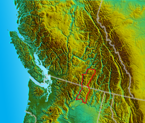
- Okanagan Highland
-
The Okanagan Highland is a plateau-like hilly area in British Columbia, Canada, and the U.S. state of Washington (where it is spelled Okanogan Highland). It lies between the Okanagan Valley on its west and the Kettle River on its east, and geologically is more or less an extension of the Thompson Plateau, which lies west of the Okanagan. Its northern perimeter is the valley of the Shuswap River, while its southern limit is the FDR Reservoir (the impounded Columbia River above Grand Coulee Dam) in Washington State. Some definitions may place the northern limit at the Coldstream Valley, east of Vernon, British Columbia, as that is the southern limit of the Shuswap Highland.
The highest summit of the Highland is Big White Mountain, at its northeastern extremity, which is also the highest summit of the Beaverdell Range, a mountain range which extends south from Big White between the Kettle and West Kettle Rivers. Other notable summits are Okanagan Mountain, Little White Mountain, Mount Baldy, and Mount Bonaparte, which is the highest summit in the US portion of the Highland.
The Okanagan Highland is the source of several rivers in addition to the Kettle and West Kettle, including the Sanpoil River.
To the east of the Okanagan Highland are the Monashee Mountains, some definitions of which include the Okanagan Highland as well as portions of the Shuswap Highland.
See also
- Quesnel Highland
- Shuswap Highland
- Geography of British Columbia
- Geology of British Columbia
- Geology of the Pacific Northwest
References
- S. Holland, Landforms of British Columbia, Province of British Columbia, 1976
- "Okanagan Highland". BC Geographical Names. http://apps.gov.bc.ca/pub/bcgnws/names/30125.html.
 Plateaus and Highlands of British Columbia
Interior Plateau Stikine Plateau Yukon Plateau Vancouver Island Categories:- Plateaus of British Columbia
- Landforms of Washington (state)
- Okanagan Country
- British Columbia Interior geography stubs
- Washington (state) geography stubs
Wikimedia Foundation. 2010.

