- Kettle River (Columbia River)
Geobox River
name = Kettle River
native_name =
other_name =
other_name1 =
.jpg)
image_size =
image_caption = The River between Monashee Mountains and Okanagan Plateau
country =United States
country1 =Canada
state =Washington
state1 =
region_type = Province
region =British Columbia
region1 =
district =
district1 =
city = Grand Forks, BC
city1 =
length_imperial = 175
length_note = [ [http://www.bartleby.com/69/87/K03387.html Kettle River] , The Columbia Gazetteer of North America]
watershed_imperial = 4200
watershed_note = [http://www.nwcouncil.org/fw/subbasinplanning/admin/level2/intermtn/plan/29_uprcol_overview.pdf Upper Columbia Subbasin Overview] , p. 29-8; Northwest Power and Conservation Council]
discharge_location = mouth
discharge_imperial = 12000
discharge_max_imperial =
discharge_min_imperial =
discharge_note =
discharge1_location =
discharge1_imperial =
source_name = Monashee Mountains
source_location =
source_district =
source_region =British Columbia
source_state =
source_country = Canada
source_lat_d =
source_lat_m =
source_lat_s =
source_lat_NS =
source_long_d =
source_long_m =
source_long_s =
source_long_EW =
source_coordinates_note =
source_elevation_imperial =
source_elevation_note =
source_length_imperial =
mouth_name = Columbia River
mouth_location = Franklin D. Roosevelt Lake
mouth_district =
mouth_region =
mouth_state = Washington
mouth_country = United States
mouth_lat_d = 48
mouth_lat_m = 40
mouth_lat_s = 22
mouth_lat_NS = N
mouth_long_d = 118
mouth_long_m = 6
mouth_long_s = 50
mouth_long_EW = W
mouth_coordinates_note = USGS; Gnis|1521637|Kettle River; retrieved May 4, 2007.]
mouth_elevation_imperial = 1500
mouth_elevation_note = [Google Earth elevation forGNIS mouth coordinates; retrieved May 4, 2007.]
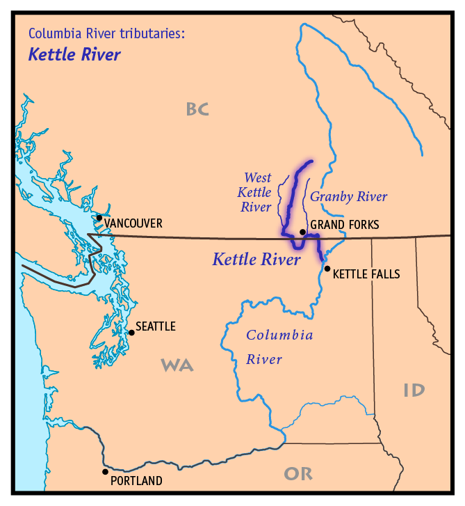
tributary_left = Granby River
tributary_left1 =
tributary_right = West Kettle River
tributary_right1 =
free_name =
free_value =
map_size = 300
map_caption = Map of the Kettle River and its two main tributaries Kettle River is a convert|175|mi|km|adj=on tributary of theColumbia River in northeasternWashington in theUnited States and southeasternBritish Columbia inCanada . Itsdrainage basin is convert|4200|sqmi|km2 large, of which convert|3177|sqmi|km2 are in Canada and convert|1023|sqmi|km2 in the United States.Course
From its source in the
Monashee Mountains of British Columbia, the Kettle River flows south toMidway, British Columbia . Along the way it is joined by many tributaries, most notably the West Kettle River. Below Midway, the river loops south into the United States, throughFerry County, Washington , before flowing north back into Canada, passing byGrand Forks, British Columbia where theGranby River joins. After flowing east for about convert|10|mi|km|0, the river turns south, entering the United States again. It then flows south, joining the Columbia River nearKettle Falls, Washington . The Columbia River at this point is a large reservoir impounded behindGrand Coulee Dam , called Lake Roosevelt. The Kettle enters the lake at the Columbia'sriver mile 706.Natural history
The Kettle River once supported
salmon and otheranadromous fish. The construction of Grand Coulee Dam, along withChief Joseph Dam , blocked fish migration up the Columbia and its upper tributaries, including the Kettle River. In addition, Grand Coulee Dam's reservoir, FDR Lake, flooded traditional fishery sites, including Kettle Falls near the mouth of the Kettle River.History
According to the USGS, the aboriginal name for the river is Ne-hoi-al-pit-kwu.
ee also
*
Tributaries of the Columbia River References
Wikimedia Foundation. 2010.